Item is Ted Newbery's thesis proposal titled "Gap Dynamics in the Sub-Boreal Spruce wk1 Biogeoclimatic Sub-Zone: Spatiotemporal Patterns, Inonotus tomentosus, and Partial Cutting". He submitted his UNBC thesis in 2002 as "Small-scale disturbances and stand dynamics in Inonotus tomentosus infected and uninfected old-growth and partial cut wet, sub-boreal forests in British Columbia".
File contains datelines, small maps consisting of ecological site types, handwritten notes, overheads, terrain resource management information digital map data, and trail system maps.
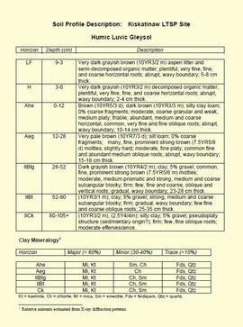
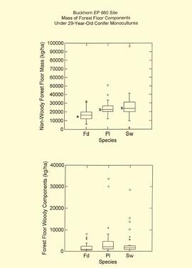
File consists of a speech given by Gary Runka entitled "BC Land Use Issues and Smiling Frogs" for the Agricultural Institute of Canada Foundation.
Commentary on this speech by Barry Smith of the Ministry of Agriculture and Lands:
"This presentation, which was accompanied by slides (not with speaking notes) reviews five diverse land use issues of which three involve agriculture, two of which were directly linked to the ALC.
The 'Smiling Frogs' metaphor is wonderfully explained as the heat is turned up and down on land use issues and complacency is something to be avoided.
GGR was directly involved in some capacity with each of the issues reviewed and, therefore is in a position to provide an "insiders" point of view. The five issues were:
- Burnaby Business Park (Burnaby Big Bend) - Lower Mainland - a very succinct overview is provided for this win-win accomplishment which directly involved ALC decision-making.
- Charlotte-Alplands (West Chilcotin) - involved an exploration of forest, recreation and wilderness tourism opportunities and the identification of potential conflicts.
- Fraser River Delta (Delta Farmland and Wildlife Trust) - considers the successful coming together of agricultural and wildlife interests in an area that has both internationally significant wildlife habitat and an important part of the Pacific Flyway but also comprises one of the best agricultural areas in Canada.
- Mid-Coast (Greenpeace and Western Forest Products) - provides insights into a very hot issue that had some success and some failure in trying to get two very opposed sides together in which the Land and Coastal Resource Management Planning process is struggling.
- Six Mile Ranch (Kamloops) - every so often the ALC is faced with what might be referred to as an application of province wide notoriety and Six Mile Ranch assuredly fit this description. The application involved a proposal in the Kamloops area (but some distance from Kamloops) to use an area of interior grasslands ALR for urban development in the form of residential, resort and golf course. GGR sums up his feelings nicely on this land issue - "My involvement in this fiasco is indirect and that of "Citizen Runka" and perhaps more specifically as a student of government stupidity."
File contains articles and government publications on the results of research projects and policies regarding the Aleza Lake Experiment Station with years ranging from 1945 to 1992. Also included are a photocopied 1926 progress report, a 1967 management manual, and guides pertaining to trails and marking stands for cutting.
Document is a BC Ministry of Forests update on proposed research for the Sulphur stable isotope tracer study (E.P. 886.15) from March 1998.
This "Soil Profile Description: Kiskatinaw LTSP Site" document provides a description of Kiskatinaw pedon.
The key results from the regional soil mineralogy study were later published as:
J.M. Arocena and P. Sanborn. 1999. Mineralogy and genesis of selected soils and their implications for forest management in central and northeastern British Columbia. Canadian Journal of Soil Science 79: 571-592. https://doi.org/10.4141/S98-07
File contains information, including diagrams, measurement charts, and a map, for experimental plot 45.
File contains information, including diagrams, measurement charts, and a map, for experimental plot 112.
File contains information, including diagrams, measurement charts, and a map, for experimental plot 118.
File contains information, including measurement charts and a map, from experimental plot 150.
File contains information, including diagrams, measurement charts, and a map, for experimental plot 103.
File contains information, including diagrams, measurement charts, and a map, for experimental plot 106.
File contains information, including diagrams, measurement charts, and a map, for experimental plot 107.
File contains information, including diagrams, measurement charts, and a map, for experimental plot 119.
File contains information, including diagrams, measurement charts, and a map, for experimental plot 148.
File contains information, including diagrams, measurement charts, and a map, for experimental plot 50.
File contains information, including diagrams, measurement charts, and a map, for experimental plot 113.
File contains information, including diagrams, measurement charts, and a map, for experimental plot 115.
File contains information, including diagrams, measurement charts, and a map, for experimental plot 116.
File contains information, including diagrams, measurement charts, and a map, for experimental plot 117.
File contains information, including diagrams, measurement charts, and a map, for experimental plot 149.
File contains information, including diagrams, measurement charts, and a map, for experimental plot 292.
File contains reports on soil rehabilitation projects and related correspondence, photocopied tables of soil measurements, and reports on machinery costs when tilling.
File contains plot summaries of selected permanent sample plots, correspondence regarding field courses, records of management committee meetings from 1991 and 1990, documents and correspondence pertaining to the re-opening of the Aleza Lake Research Forest, partial cutting summaries, research proposals and studies, cost and revenues documents, a 1961 biography on Percy Barr, charts covering remeasurements of permanent sample plots, hand written correspondence from 1990 discussing the history of marking crews, and a brief history of the Aleza Lake Experiment Station.
File contains information, including diagrams, measurement charts, and a map, for experimental plot 291.
File contains maps, working plans, and related correspondence.
Item is a computer print-out of PSP data from Aleza Lake Research Forest.
File contains maps and information related to climate station installation, including reports and tables.
File contains 1998 proposals and other correspondence between the Ministry of Forests and the Aleza Lake Steering Committee regarding the future management of the Aleza Lake Research Forest.
File contains Aleza Lake Experiment Station Climate Station data from 1952 to 1980 and three accompanying floppies with weather data and Fortran programs.
File contains original and photocopied drafts of working plans and drafts, planning projects, original amendments to special use permits, handwritten notes, related correspondence, and photocopied maps.
This digital document is a born-digital PDF containing details of forest floor sample collection & handling for the EP 660 Buckhorn Ridge installation.
This digital document is a scanned PDF of a Prince George Forest Region Forest Research Note #PG-12: "Experimental Project 660 - Overview of Three Experimental Installations - A 30-year Progress Report".
This paper by Brad Hawkes describes, from a newspaper media's perspective, changes in how fires were fought, reported, and described from 1912-1961 for significant fire years in the Prince George area.
Zonder titelThis Ministry of Forests internal memorandum of 30 June 1997 from Paul Sanborn to Regional & Research Branch soil scientists provides comparison of Morgan's extractant and BaCl₂ for cations, using the 57 samples from the regional soil mineralogy study.
The key results from the study were later published as:
J.M. Arocena and P. Sanborn. 1999. Mineralogy and genesis of selected soils and their implications for forest management in central and northeastern British Columbia. Canadian Journal of Soil Science 79: 571-592. https://doi.org/10.4141/S98-07
This digital document is a scanned PDF of a Prince George Forest Region Forest Research Note #PG-12-1: "Experimental Project 660 - 30-year Progress Report - Buckhorn Installation".
"Mineralogy of clay and sand fractions of soils developed from till, glaciofluvial and glaciolacustrine deposits in central interior British Columbia" was a preliminary internal report that provides some background to Arocena and Sanborn's regional soil mineralogy study, as well as a compilation of the mineralogical data.
The key results from this work were later published as:
J.M. Arocena and P. Sanborn. 1999. Mineralogy and genesis of selected soils and their implications for forest management in central and northeastern British Columbia. Canadian Journal of Soil Science 79: 571-592. https://doi.org/10.4141/S98-07
File contains a 1997 field tour guide of the Aleza Lake Research Forest, and 1997 and 1998 government publications on research projects conducted at the forest.
File contains correspondence regarding lack of funding for research projects between the Science Council of British Columbia and Mike Jull, Prince George Forest Region.
File contains research project reports and charts of remeasured permanent sample plots.
File contains a brochure, a 1993 solid waste management plan, a 1996 Forest Practices policy handbook, and a 1996 draft of the Prince George Land and Resource Management Plan.
File consists of working copies of aerial photos, vegetation tables printed from computer disk, photocopies of plot sheets, and lists identifying species.
File consists of:
- "A Summary of Historical Orders-in-Council affecting the Aleza Lake Forest Reserve", Mike Jull, 18 Dec. 1996
- Photocopied memorandum from F.S. McKinnon regarding "Transfer of Aleza Lake to D.F. Prince George", 9 Sept. 1963
- Photocopied 1928 article by P.M. Barr from Forestry Chronicle 4(3) entitled "The Aleza Lake Experiment Station: Its Development and Purpose"
- "A Brief History of the Aleza Lake Experiment Station", [Tim Decie, 1981?]
- Contact information for living relatives of Percy Barr, as of 1990
- Photocopy of 1930 article by Percy Barr entitled "Spruce Reproduction in British Columbia"
- Photocopy of records from BC Archives from a visit by Harry Coates from the file GR 1348 "The Young Mens Forestry Training Program"
- Photocopy of excerpt regarding "Amanita Lake/Diameter Limit Logging"
- Various small-scale maps and charts regarding Aleza Lake
- "Aleza Lake Research Forest Information Session Notes with Mike Jull, Manager of ALRF"
The Canadian Pacific Railway (CPR) series consists of materials documenting CPR operations in British Columbia from 1927-1996. Series includes correspondence, time tables, publications and ephemera used or created by Canadian Pacific. Also comprises tariff and freight materials developed by Canadian National Railways and the Canadian Freight Association used by Canadian Pacific.
Zonder titelFile contains correspondence regarding funding for research project and computer generated maps.
This born-digital "Profile Descriptions" document provides descriptions of Williams Lake (Skulow Lake), Aleza 1 & 2, Log Lake, and Lucille Mountain pedons.
The BC Ministry of Forest's EP 1148 Long-term Soil Productivity (LTSP) study addresses two key factors— soil porosity and site organic matter—that potentially limit tree growth and site productivity in the timber-harvesting land base and that can be affected by forestry operations.
This establishment report for EP 1148, "The effects of soil compaction and organic matter retention on long-term soil productivity in British Columbia (Experimental Project 1148)", is accompanied by a floppy disk containing 12 data sets (see 2023.2.2.11.2).
File contains drafts of management and working plan for the period of 1992 to 2002, the final draft for the management and working plan, and related correspondence between Mike Jull and those involved with the Aleza Lake Research Forest.
File contains general correspondence from 1981 through 1998 regarding various administrative issues including road maintenance and the 1992 reopening of the Aleza Lake Research Forest. The file also contains a 1994 inventory of the Northwood donation to the Fraser-Fort George Museum.