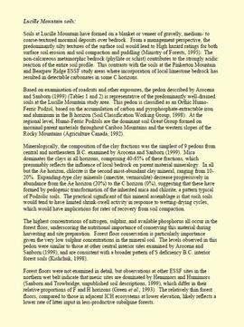
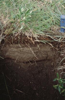
The photograph depicts the Grand Trunk Pacific Railyard roundhouse and water tower in Prince George, B. C. Reverse side of photograph states, "Photo Credit: Fort George Museum." Reproduction from [192-?].
The photograph depicts dozens of workers walking towards and laying train tracks in the winter. A train car that is helping lay the track. Location is Prince George, B. C. The number 6 is written on the photograph in marker and circled. Reverse side of photograph states, "Photo Credit: Fort George Museum." Reproduction from [191-?].
File consists of notes, clippings, and reproductions relating to Salmon River.
The photograph depicts a newspaper article discussing the Grand Trunk Pacific Railway being built at Stuart River. Annotation on slide states, "Stuart R. ad."
File consists of notes and reproductions relating to the Tabor Creek Elementary School and Tabor Creek South Elementary School
File consists of a note relating to St. Marie's Lake Elementary School.
File consists of notes relating to the Red Rock Elementary School. Includes photographs depicting the old Red Rock school, a wooden weathered building, and the new Red Rock school (2001).
File consists of notes relating to Camp Creek Elementary School.
Image depicts a cookhouse at an uncertain location.
Image depicts two small sheds at an uncertain location. The slide labels them as "Giscome bldgs in Blackburn."
File consists of clippings, notes, and reproductions relating to golf course history in Prince George. Includes information and clipped articles on the Prince George Golf and Curling Club and the Fort George Park golf course.
The item is a photograph depicting a white boarded up workshop. The photograph was taken from a road.
The item is a photograph depicting a front view of an old white barn with a rainbow painted on the front.
The item is a photograph depicting a front and side view of an old white barn with a rainbow painted on the front. The photograph is taken from a field.
The item is a closeup black and white photograph depicting the front of an old white barn with a rainbow painted on the front.
The item is a closeup black and white photograph depicting the front and side of an old white barn.
The item is a black and white photograph depicting a garage and covered storage area on a farm.
The item is a black and white photograph depicting a boarded up workshop on a farm.
The item is a black and white photograph depicting the front of a white house in a rural location.
The item is a black and white photograph depicting the front and side of a white house on a farm.
Floppy consists of G.G. Runka Land Sense Ltd. client file records for jobs.
Floppy directories and file listing:
- 554Final Report.doc
This born-digital "Lucille Mountain soils" document provides a description and basic data for the Lucille Mt. pedon.
Document prepared by P. Grilz contains species lists and UTM coordinates for 10 sampling locations for the M-K-2001-2002-81 Seed Project.
File contains the following data sets:
- Phytolith contents.xls [phytolith content in 5-20 µm silt, tallied by morphological categories; also summarized as % of total soil fine (< 2 mm) fraction]
- M-K (2001) soil LOI data.pdf [LOI (loss-on-ignition) data for sampled soil horizons – proxy measurement for organic matter content]
This CD-ROM contains a backup of Gary Runka's and Joan Sawicki's business and personal digital records. Includes records relating to client jobs, Land Sense Ltd. company records, brochures, invoices, correspondence, drafts, reports, and other documents. Includes digital records for client files 554, 568, 587, 595, and 600.
This CD-ROM contains a backup of Gary Runka's and Joan Sawicki's business and personal digital records. Includes records relating to client jobs, Land Sense Ltd. company records, brochures, invoices, correspondence, drafts, reports, and other documents. Includes digital records for client files 568, 587, 590, 601, 615, 622, 626, among others.
This map is part of Schedule B of the 1993 Official Community Plan, Bylaw No. 5909 for the City of Prince George. This particular map reflects the 1998 amendment to the Official Community Plan.
The item is a photograph depicting a dirt road in Ten Mile Park, BC. Annotation on reverse side of photograph states, "in 10 ml park."
The item is a photograph depicting Clanston Road. Annotation on reverse side of photograph states, "Clanston Rd."
The item is a photograph depicting a roadbed in a forest. Annotation on reverse side of photograph states, "roadbed mn road."
The item is a photograph depicting a hiking trail West of Osprey Rd. in BC. Annotation on the reverse side of the photograph states, "W. of Osprey Rd."
The item is a photograph depicting the exterior of the Woodpecker School. The log school is dilapidated with a caved in roof.
The item is a photograph depicting the old, wooden Salmon Valley elementary school relocated to La Casse farm. The building is weathered with fading paint, a rusted roof and boarded up windows. There is a rusted bicycle, a rusted barrel and other debris in front of the building. Annotation on reverse side of the photograph states, "teacher illegible handwriting La Casse farm." Acompanying note states, "#6 La Casse farm."
The item is a photograph depicting the exterior of the Woodpecker School. The log school is dilapidated with a caved in roof. Annotation on reverse side of photograph states, "Nov 2001."
The item is a photograph depicting a field where the site where the Sylvan Glade elementary school was located at Vivian Lake. Annotation on reverse side of photograph states, "Sylvan Glade school site #1."
The item is a photograph depicting the weathered Hart Highway schoolhouse. The school is shown at its relocation to the Myatovic farmland. Annotation on reverse side of photograph states, "east building, n. end, view se." Accompanying note with photograph states, "Shady Valley relocation to Myatovic farm property."
The item is a photograph depicting the weathered Hart Highway schoolhouse. The school is shown at its relocation to the Myatovic farmland. Annotation on reverse side of photograph states, "east building s. end looking NE - from Hart Hwy."
The item is a photograph depicting the front rear side of the log Hixon schoolhouse. A weathered white building is situated next to the old school. A lens flare obscures the center of the photograph. Annotation on reverse side of photograph states, "APS Hixon School."
The item is a photograph depicting the front and side of the log Hixon schoolhouse. Annotation on reverse side of photograph states, "Canyon Cr. (Hixon)."
The item is a photograph depicting the Red Rock school circa. 2001.
The item is a photograph depicting the rear side of the log Hixon schoolhouse. Annotation on the reverse side of the photograph states, "APS."
The item is a photograph depicting the rear side of the log Hixon schoolhouse.
The item is a photograph depicting the front and side of the Prince George Snowmobile Club. The building was originally Buckhorn school. The building is wooden with a metal roof.
The item is a photograph depicting schoolchildren in front of the Bonnet Hill school. The photograph is a photograph taken of the original print. Annotation on reverse side of the photograph states, "Bonnett Hill school, photo in pub." The Bonnett Hill pub is located at 6957 Giscome Road, Prince George.
The item is a photograph depicting the front and side of the old Beaverly school. The school is a weathered, wooden building. Annotation on reverse side of the photograph states, "Kodak Gold 200."