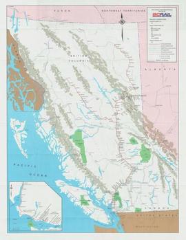
Map depicts Canadian railways in operation at 2011.
The item is a map that depicts subdivision lots along the Fraser River in Prince George. The subdivision is DL 745 and 747 of the Cariboo District. Map is certified by G. F. Templeton, a BC land surveyor.
This map is the May 2008 amendment (Bylaw 8061) of the Schedule C of the 2001 Official Community Plan, Bylaw No. 7281 for the City of Prince George. This Schedule C map shows the long range land use for the City of Prince George.
This map is the October 2006 amendment (Bylaw 7807) of the Schedule C of the 2001 Official Community Plan, Bylaw No. 7281 for the City of Prince George. This Schedule C map shows the long range land use for the City of Prince George.
This map is the May 2006 amendment (Bylaw 7807) of the Schedule C of the 2001 Official Community Plan, Bylaw No. 7281 for the City of Prince George. This Schedule C map shows the long range land use for the City of Prince George.
The item is a reproduction of a map originally surveyed in 1984 by F. A. Deveraux. The map is a plan of the "Fort George Indian Reserves" in the Cariboo District. Annotations include the approved signatures of Leo. B. Martin and R. O'Reilly dated 21 September 1895.
This street map of the VLA area in Prince George includes property outlines and street numbers.
This map is Schedule C of the 2001 Official Community Plan, Bylaw No. 7281 for the City of Prince George. This Schedule C map shows the long range land use for the City of Prince George.
This map is part of Schedule B of the 1993 Official Community Plan, Bylaw No. 5909 for the City of Prince George. This particular map reflects the 1998 amendment to the Official Community Plan.
Item is a British Columbia Forest Cover Map, serial number 093J010. Includes full format forest cover labels.
This Slocan Group forestry development plan highlights contributing obstacles to the development like the Pine Beetle infestation.
The map depicts Prince George lots alongside the Fraser River and has annotations by Kent Sedgwick outlining the location of the original cemetery. The map is a reproduction created in August 1910 and revised in 1965. Copy was produced between 1980 and 2000.
Map depicts range reference area exclosure locations for livestock and wildlife in the Fort St. John Forest District.
Item is a British Columbia Forest Cover Map, serial number 093I001. Includes full format forest cover labels.
The item is a map depicting the Salmon Portage area along the Salmon River. Various annotations are written in pen and sections of the map are coloured with pencil crayon. The Forest Cover Map identification number is 93J.027.
This map is the Schedule A accompanying map for the City of Prince George's Soil Removal and Deposit Bylaw No. 7022 of 1999. It depicts designated soil removal areas and M.O.T.H. gravel reserves.
The item is a map depicting the Crooked River Provincial Forest area. Sections of the map are highlighted and coordinates are annotated in ink.
This map depicts the location of the Archie Creek site, annotated on a photocopied 93I.011 BC government map (undated).
Mylar map depicts the area encompassed by the Aleza Lake Research Forest.
The item is a map depicting the Salmon Portage area along the Salmon River. Various annotations are written in pen and sections of the map are coloured with pencil crayon. The Forest Cover Map identification number is 93J.026.
This map depicts the City of Prince George's plan for soil removal and deposit.
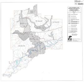
Map commissioned from Ministry of Forests Prince George Region from Madrone Consultants shows Aleza Lake Research Forest Management Compartments and Administrative Boundaries. Map is 1 of 6. Map shows the Aleza Lake Ecological Reserve, Natural Forest Reserve, the Special Management Area, and Riparian Management Research Area.
Map commissioned from Ministry of Forests Prince George Region from Madrone Consultants shows Aleza Lake Research Forest Research Trials and Permanent Plots. Map is 2 of 6. Map shows permanent plot locations, historical timber sales areas, demonstration areas, and research plots.
Map commissioned from Ministry of Forests Prince George Region from Madrone Consultants shows Aleza Lake Research Forest terrain themes. Map is 6 of 6. Map shows the following types of terrain units: typic, slope, percipitous, gullied, hummocky, rocky, alluvial, and organic. Ecosystem classification and mapping by Oikos Ecological Services Ltd.
Map indicates locations of research trials and permanent plots in the Aleza Lake Research Forest. Map produced by Madrone Consultants.
Map commissioned from Ministry of Forests Prince George Region from Madrone Consultants shows an Aleza Lake Research Forest TRIM Base Map. Map is 4 of 6. Map shows the following: roads, old roads, buildings, rail line, transmission line, definite streams, intermittent streams, indefinite streams, marshes, swamps, lakes, wooded area boundaries, intermediate contour lines (20m intervals), and index contour lines (100m intervals).
Map commissioned from Ministry of Forests Prince George Region from Madrone Consultants shows Aleza Lake Research Forest Terrain Resource Inventory Mapping (TRIM). Depicts roads, area boundaries, swamps, streams, marshes, contour lines and index lines.
Map depicts the route of BC Rail and its connecting rail lines.
Map commissioned from Ministry of Forests Prince George Region from Madrone Consultants shows Aleza Lake Research Forest Access and Access Management. Map is 3 of 6. Map shows the following road types: all weather 1-lane gravel road, dry weather road, and proposed road access. Also shows areas for parking/turnaround, toilets, and information signs.
Map commissioned from Ministry of Forests Prince George Region from Madrone Consultants shows Aleza Lake Research Forest ecosystems. Map is 5 of 6. Map shows many sub-types of the following ecosystem types: upland, lowland wet forest, wetlands, and the Bowron floodplain benches. Ecosystem classification and mapping by Oikos Ecological Services Ltd.
Map commissioned from Ministry of Forests Prince George Region from Madrone Consultants shows Aleza Lake Research Forest site series classification. Shows ecosystem types that encompass the SBSwk1 Subzone of the Aleza Lake Research Forest.
This map is part of Schedule B of the 1993 Official Community Plan, Bylaw No. 5909 for the City of Prince George. This particular map reflects the 1998 amendment to the Official Community Plan.

![City of Prince George - Schedule C of the Official Community Plan - Long Range Land Use Map [May 2008 Amendment]](/uploads/r/northern-bc-archives-special-collections-1/4/3/a/43a9e75941f1542735d999de340307d163e79dffdadbf4546bb9346b63f7e734/2023.5.1.41_-_2008_May_-_City_of_Prince_George_Long_Range_Land_Use_Map_JPG85_tb_142.jpg)
![City of Prince George - Schedule C of the Official Community Plan - Long Range Land Use Map [October 2006 Amendment]](/uploads/r/northern-bc-archives-special-collections-1/6/d/6/6d643c10801eba2ac493689972e57429dba42ec7592f54cb55151b96362d7048/2023.5.1.40_-_2006_Oct_-_City_of_Prince_George_Long_Range_Land_Use_Map_JGP85_tb_142.jpg)
![City of Prince George - Schedule C of the Official Community Plan - Long Range Land Use Map [May 2006 Amendment]](/uploads/r/northern-bc-archives-special-collections-1/6/5/5/65536bc04aa97580c140131651dc357dfe5c3a1315822394f388d96940bc39cb/2023.5.1.39_-_2006_May_-_City_of_Prince_George_Long_Range_Land_Use_Map_JPG85_tb_142.jpg)


![City of Prince George - Schedule B of the Official Community Plan, Bylaw No. 5909 [2001 Amendment]](/uploads/r/northern-bc-archives-special-collections-1/c/3/6/c36392b90696286cc6281e8cc2efbf7691c2617726495fa28db2cbdcc20e4e4c/2023.5.1.36_-_Official_Community_Plan_City_of_PG_Schedule_B_2001_JPG85_tb_142.jpg)


![City of Prince George - Schedule B of the Official Community Plan, Bylaw No. 5909 [1998 Amendment]](/uploads/r/northern-bc-archives-special-collections-1/d/6/d/d6d1c4e7e37fc948b97b3caa36447b52f7d2b76b13d45e3710aefee7b13840f0/2023.5.1.33_-_1998_Official_Community_Plan_City_of_PG_JPG85_tb_142.jpg)


