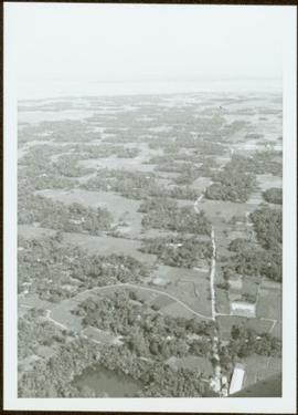
Previsualizar a impressão Fechar

Mostrar 4134 resultados

Archival description
3619 resultados com objetos digitais Mostrar resultados com objetos digitais
Dunlevy Creek?
2012.13.1.50.137 · Item · 2006
Parte de J. Kent Sedgwick fonds

Image depicts the Dunlevy Creek area somewhere near Dawson Creek, B.C. The slide is simply labelled "Dunlevy irrigation" for uncertain reasons.

Mount Sir Alexander
2012.13.2.19.12 · Dossiê/Processo · 2006-2010
Parte de J. Kent Sedgwick fonds

File consists of notes, clippings, and reproductions relating to Mount Sir Alexander, a mountain in the Sir Alexander Area of the Continental Ranges of the BC Canadian Rockies.

Dominion Land Survey system
2012.13.2.02.24 · Dossiê/Processo · [2007?]
Parte de J. Kent Sedgwick fonds

File consists of notes and reproductions relating to the Dominion Land Survey system. File primarily consists of photocopies of original township layout systems between 1881 and 1917 and printed secondary sources on the standardization of the Dominon Land Survey system in British Columbia and Alberta.

Hatley Park, Victoria
2012.13.2.02.41 · Dossiê/Processo · 2007
Parte de J. Kent Sedgwick fonds

File consists of notes and reproductions relating to Hatley Park, Victoria, which was designed by landscape architects Brett and Hall. Brett and Hall had also assisted in city planning in Prince George. File also contains a CD titled "RRU Archives Brett and Hall Hatley Plans" containing material about the Brett and Hall Hatley plans from the Royal Roads University Archives.

Inventory of Prince George and region maps
2012.13.2.11.06 · Dossiê/Processo · 2007
Parte de J. Kent Sedgwick fonds

File consists of notes relating to Kent Sedgwick's collection of maps depicting Prince George and region. File primarily includes handwritten and typed notes from Kent Sedgwick describing and listing various maps he had in his collection.

Fort Alexandria
2012.13.2.19.07 · Dossiê/Processo · 2007-2010
Parte de J. Kent Sedgwick fonds

File consists of notes and reproductions relating to Fort Alexandria (later renamed Alexandria). Fort Alexandria was an HBC trading post, ferry site, and steamboat landing in the North Cariboo, 45 km south of Quesnel. File contains photographs depicting Fort Chilcotin, the landscape and buildings (Sept. 1983 and Aug. 2006).

Interior rainforest
2012.13.2.11.13 · Dossiê/Processo · 2008
Parte de J. Kent Sedgwick fonds

File consists of notes, clippings, and reproductions relating to the central interior rainforest and the Ancient Forest/Chun T'oh Whudujut Provincial Park and Protected Area.

Guest lecture on historical geography in New Caledonia
2012.13.5.02 · Dossiê/Processo · 2008
Parte de J. Kent Sedgwick fonds

File consists of notes relating to Kent Sedgwick's guest lecture on historical geography and transportation routes in New Caledonia, including the interior plateau of Central British Columbia. Includes correspondence with James Windsor, the instructor for the course, and Kent Sedgwick's notes for the lecture.

View of Crusher Construction Site from Above
2000.1.1.2.2.13 · Item · 1963
Parte de Cassiar Asbestos Corporation Ltd. fonds

Men can be seen working on site, building tools and supplies scattered throughout. Handwritten caption beside this photo reads: "View showing various levels of foundations". A chute of some kind extends from high level to men near bottom. Dirt road at site, and tree-covered valley can be seen in background. Construction of a long structure near the edge of the excavation area can be seen in midground; this is believed to be conveyor "B".

Blasthole Drill
2000.1.1.2.2.35 · Item · 1963
Parte de Cassiar Asbestos Corporation Ltd. fonds

Four construction workers stand to left of blasthole drill number "604" among many empty cardboard boxes. Mountain range can be seen in background.

Lowering Crusher Pinion into Place
2000.1.1.2.2.39 · Item · 1963
Parte de Cassiar Asbestos Corporation Ltd. fonds

Handwritten caption beside this photo reads: "Placing Crusher Pinion; Pitman; weight approx. 20 tons". Man stands on top of a very tall, red peice of equipment believed to be a crusher pitman. Boom of crane is visible in foreground, and two other men stand on a high level of the crusher building. Crusher foundations, an unidentified building, and mountain in background.

Construction Workers on Top of Crusher Building
2000.1.1.2.2.47 · Item · 1963
Parte de Cassiar Asbestos Corporation Ltd. fonds

Photograph depicts the steel sheeting of the crusher building underway. Three men stand on platform suspended by cables close to roof of crusher building. Three other men can be seen working on the roof of the building, one walking, one sitting, one lying on his stomach very close to the edge. All are wearing safety gear. Cassiar mountain range in background.

Retaining Wall at Crusher Site
2000.1.1.2.03.05 · Item · 9 July 1964
Parte de Cassiar Asbestos Corporation Ltd. fonds

Handwritten annotation on recto of photograph: "RETAINING WALL POUR JULY 9/64." Photograph depicts construction workers among machinery near retaining wall under conveyor of crusher building. Crane stands on left, front end loader and back hoe tractor in foreground on right. Mountainside in background.

Retaining Wall at Crusher Site
2000.1.1.2.03.07 · Item · 9 July 1964
Parte de Cassiar Asbestos Corporation Ltd. fonds

Handwritten annotation on recto of photograph: "RETAINING WALL POUR JULY 9/64." Photograph depicts two construction workers standing on retaining wall in foreground. Two other men stand near a crane operating in midground, with its load suspended above men on wall. Crane stands on road between a building and retaining wall, mountain range in background.

Construction Work near West Wall at Crusher Site
2000.1.1.2.03.10 · Item · 19 August 1964
Parte de Cassiar Asbestos Corporation Ltd. fonds

Handwritten annotation on recto of photograph: "FORMING & STEEL WORK AUG 19/64." Photograph depicts construction workers among machinery on high elevation of crusher site. It is believed that a front end loader and concrete mixer stand in this area. Forms for cement made of wood and rebar can be seen in foreground on left, retaining wall on right. Building top and mountain range visible in background.

Men & Bulldozer on Mining Bench
2000.1.1.3.15.01 · Item · 1953
Parte de Cassiar Asbestos Corporation Ltd. fonds

Photograph depicts two men standing on mining bench in mountainside, three boxes and what appears to be a long hose to the left. Third man and tractor plow can be seen in distance at end of bench. Photo caption next to printed copy of image in 1953 Annual Report: "Benches being prepared for mining."

Two Men in Mine
2000.1.1.3.15.05 · Item · [ca. 1955]
Parte de Cassiar Asbestos Corporation Ltd. fonds

Photograph depicts two unidentified men at high elevation on mountain. Trucks and tanks visible in background, hose (possibly of air track drill) in right foreground. Mountain range in background.

Dozer on Cliff
2000.1.1.3.15.11 · Item · [ca. 1958]
Parte de Cassiar Asbestos Corporation Ltd. fonds

Photograph depicts unknown man driving bulldozer on edge of mine area at high elevation. The dozer is an International model TD24 (manufactured between 1947 and 1955). A second man stands on edge of cliff, directing driver. Mountain range in background.

Two Dozers on Cliff
2000.1.1.3.15.12 · Item · [ca. 1958]
Parte de Cassiar Asbestos Corporation Ltd. fonds

Photograph depicts unknown men driving bulldozers on edge of mine area at high elevation. Dozers are Internationals, model TD24 (manufactured between 1947 and 1955). Mountain range in background.

Dozer on Cliff, Close View
2000.1.1.3.15.14 · Item · [ca. 1958]
Parte de Cassiar Asbestos Corporation Ltd. fonds

Photograph depicts unknown man driving bulldozer near edge of mine area at high elevation. Dozer is an International model TD24 (manufactured between 1947 and 1955). Valley and mountain range in background.

Shovel & Haul Trucks
2000.1.1.3.15.15 · Item · [ca. 1958]
Parte de Cassiar Asbestos Corporation Ltd. fonds

Photograph depicts cable-operated shovel loading Kenworth haul truck on road in mine area at high elevation. Pickup truck in background, four unidentified men are gathered around second Kenworth truck in foreground. Valley and mountain range in distance.

Plantsite
2000.1.1.3.18 · Dossiê/Processo · 1953 - 1989
Parte de Cassiar Asbestos Corporation Ltd. fonds

This file contains operations at the plantsite:
Below is synopsis of the item level descriptions (see each item for further description)

  • locations depicted at Plantsite: mill building, dry rock storage building, tailings pile, gravel pit, power house, and office.
  • delivery and installation of a Caterpillar engine, welding repairs underway on a Rustin Diesel Engine in the power house, staff portrait taken by the main office building, and fibre testing
    Not done to item level but integrated into subseries file:
  • Photographic negatives included depict milling and packaging machinery in the mill building.
  • 93 slides depicting various activities and equipment at the plantsite including: dry rock storage, screens, collectors, loading trucks, bagging, pallets, tailing pile, lab work by engineers, lab equipment, fibre testing, and fibre samples.
  • photographs of conveyor foundations, tailings equipment, Grizzly truck, containers from site mechanical inspection, and portable crushing plant in June 1991.
  • photos of fibre samples from lab - on display
  • collection of photos of 1970 Mill modification Program of April 1978
  • collection of photos from 1961 and 1962 of plantsite lab and asbestos samples. file labeled "Suter - Webb VU Graph Analysis" and "Suter - Webb and Turner Comb Analysis"
  • Pressure Packer modification photos done by Chapman Industries in 1986
  • Powerhouse equipment from 1979
  • additional 43 slides of inside the mill in June 1978. Slides were used at a board meeting.
  • negatives of inside of mill
  • A photo album of 162 photographs depicting various operations at the plantsite including: drill dust collector, outdoor surroundings, conveyors, and the mine site. (album was originally labelled "Cassiar Plantsite).
1961 - 6430 Ore Bench
2000.1.1.3.19.002 · Item · July 1961
Parte de Cassiar Asbestos Corporation Ltd. fonds

Photograph depicts bench at 6430 elevation. Blasthole drills, shovels, dozers, and dump trucks can be seen on bench in midground. Mine valley in background. Handwritten annotation on verso of photograph: "1961".

1961 - Shovel on Peak
2000.1.1.3.19.012 · Item · 1961
Parte de Cassiar Asbestos Corporation Ltd. fonds

Photograph depicts a crawler cable shovel on right, and bulldozer partially visible on left. Rock face of mountainside in background. Handwritten annotation on verso of photograph: "1961", on recto: "Mining 80 D shovel on [?] 64/70 to 6560 saddle on peak."

Explosion of plug for diversion route
2000.13.1.64 · Item · [between 1962 and 1967].
Parte de Ray Williston fonds

Item is a photograph of the explosion which opened up the diversion route for the Peace River during construction of the W.A.C. Bennett Dam.

Three diversion tunnels
2000.13.1.66 · Item · [between 1962 and 1967].
Parte de Ray Williston fonds

Item is a photograph of the three tunnels built to divert the Peace River around the Bennett Dam construction site.

Articles and papers written about Knox McCusker
2008.27.3 · Dossiê/Processo · 1935-1997
Parte de Knox McCusker Collection

File consists of the following items:

  • "Mac" by D.L. Surveyor
  • "Knox (Mac) McCusker: Dominion Land Surveyor" by E.L. Rutherford, V.C. Brink, R.S. Silver and M.Z. (Smokey) Neighbour
  • Excerpts from Men and Meridians by Don W. Thomson
  • Article re: Knox McCusker written on the occasion of his death (April 14, 1955)
  • "McKusker (sic) to open up Blueberry Mountain Area" (Alaska Highway News, June 8, 1950)
  • "McCusker was surveyor, big game guide….also rancher and trail blazer"
  • "Knox Freeman McCusker" written on the occasion of his death (The Canadian Surveyor, July 1955)
  • "Veteran Surveyor - Alaska Highway Stories"
  • Memories of Knox McCusker by his oldest niece Betty (McCusker) Rutherford
  • "Veteran Surveyor prefers horses for long bush treks" by Eric Young (Edmonton Journal)
  • Eulogy for Knox McCusker read by Stanley D. Seif at Burch Presbyterian Church in Fort St. John, B.C.
  • Eulogy for Gwendolyn Dorothy McCusker (July 1997)
  • "Tropical Valley No Myth: amazing story of woman who lived there" by Thomas A. Wayling (Vancouver Sun)
  • Photocopy of section of map: "Topographical sketch map showing route traversed by the Bedaux Sub-Arctic Expedition 1934 through the Rocky Mountains" (by Frank Swannell, March 27, 1935)
  • Memories of Knox McCusker by Bill McCusker, his oldest nephew
  • "There is always a reason; destiny made it a date. The corridor of the Alcan didn’t just happen" (Fort St. John publication)
  • Article on Knox McCusker (ALS News, Winter 1983)
Finlay River Rapids, B.C.
2009.5.1.42 · Item · 1930
Parte de Taylor-Baxter Family Photograph Collection

Handwritten caption below this photo reads: "Finlay River Rapids. - 1930."
A small peninsula extends into river in left midground, rapids in foreground, trees and hills on opposite shore in background.

Unidentified Man at Log Cabin
2009.5.1.50 · Item · [ca. 1910]
Parte de Taylor-Baxter Family Photograph Collection

Photograph depicts a man seated with bundles and briefcase in front of two small log cabins with sod roofs. What appears to be an elevated log cache stands to left behind cabins, with a ladder raised to its door. Rocky, dry field crosses foreground, mountains visible in background.

Hagwilget Bridge Crosses Bulkley River
2009.5.1.70 · Item · [ca. 1900]
Parte de Taylor-Baxter Family Photograph Collection

Close view of bridge built with wooden planks, poles, and wires, braced from below, with triangles built into its frame. The bridge crosses Hagwilget Canyon on the Bulkley River, five kilometres from its confluence with the Skeena River. This is one of the many bridge structures that have crossed this location since at least 1859. Photograph was taken from one side of canyon, near bridge. Opposite canyon wall in background. Typed annotation glued to verso of photograph: "HAGWILGET - 'the gentle or quiet people'."

Hagwilget Bridge Crosses Bulkley River
2009.5.1.71 · Item · [ca. 1900]
Parte de Taylor-Baxter Family Photograph Collection

Photograph depicts two men and a horse on a bridge built with wooden planks, poles, and wires, braced from below, with triangles built into its frame. The bridge crosses Hagwilget Canyon on the Bulkley River, five kilometres from its confluence with the Skeena River. This is one of the many bridge structures that have crossed this location since at least 1859. Photograph was taken from a distance. Rocky riverbank in foreground, opposite shore in background behind bridge. Typed annotation in red ink on verso of photograph: "INDIAN BRIDGE, NEAR HAZELTON, B.C."

Cariboo Road Postcard to H.F. Glassey
2009.5.2.31 · Item · [ca. 1900]
Parte de Taylor-Baxter Family Photograph Collection

Handwritten annotation on verso of photograph: "Early Days on the Cariboo Road. No. 8." Photograph depicts man driving two covered wagons pulled by team of six horses on gravel road. Valley crosses midground, hills in background. Handwritten annotation on recto of photograph: "H. F. Glassey Esq. P.O Box 950 Prince Rupert B.C. Dear Bert: We have been kept very busy have been on committee work all through the convention but it was wonderful will write you a long letter from Vancouver. Mrs Earley wants me to stay until Monday morning train. Met Mr. [Colley?] everything going fine here. I am sure you are busy [...?] Love from Sadie. Mr & Mrs. [Graif?] are living here."

Hydro Power Plant, Prince Rupert, BC
2009.5.2.59 · Item · [ca. 1930?]
Parte de Taylor-Baxter Family Photograph Collection

Photograph depicts power plant by waterfall. Extensive construction materials and structures can be seen scattered to left of plant. River in foreground, forest and hills in background. Typed annotation on verso of photograph: "Northern B.C. Power Co. Falls River Plant Prince Rupert B.C."