Item is an original copy of a 1982 technical report presented to the British Columbia Utilities Commission by G.E. Cheesman and R.L. Davis of the Ministry of Environment Air Studies Branch entitled "The Agroclimate of the Peace River Valley and a Comparison with other Locations in British Columbia".
File consists of records created and accumulated by Gary Runka over the course of his consultancy work for BC Ministry of Lands, Parks and Housing for the "Moberly DPA" project in Fort St. John. This file was numbered as G.G. Runka Land Sense Ltd. client file #079; that client number may be seen referenced elsewhere in the G. Gary Runka fonds. The Land Sense Ltd. client files generally include records such as correspondence, contracts, invoices, project reports, publications, ephemera, memoranda, maps or map excerpts, legal documents, meeting materials, clippings, and handwritten notes.
Maps include:
- "Moberly River" NTS map annotated with Soils & Landforms;
- "Moberly Crown Land Plan Area - Land Capability for Agriculture Interpretation" by G. G. Runka Land Sense Ltd., 1982;
- "Hudson Hope" 1964 NTS map annotated with Soils & Landforms;
- "Moberly Crown Land Plan Area", n.d. - 2 copies;
- "Climate Capability for Agriculture 94A-SW", 1970.
File consists of records created and accumulated by Gary Runka over the course of his consultancy work for Environment Canada, Lands Directorate for the "Okanagan Fruitlands Study" project. This file was numbered as G.G. Runka Land Sense Ltd. client file #083; that client number may be seen referenced elsewhere in the G. Gary Runka fonds. The Land Sense Ltd. client files generally include records such as correspondence, contracts, invoices, project reports, publications, ephemera, memoranda, maps or map excerpts, legal documents, meeting materials, clippings, and handwritten notes.
Item is an original copy of "Ten Years of Agricultural Land Preservation" the 1983 anniversary publication by the Provincial Agricultural Land Commission.
File consists of records created and accumulated by Gary Runka over the course of his consultancy work for BC Hydro for the "Capability Analysis and Land Use Concept Plan - West Arrow Park" project in West Arrow Park. This file was numbered as G.G. Runka Land Sense Ltd. client file #057; that client number may be seen referenced elsewhere in the G. Gary Runka fonds. The Land Sense Ltd. client files generally include records such as correspondence, contracts, invoices, project reports, publications, ephemera, memoranda, maps or map excerpts, legal documents, meeting materials, clippings, and handwritten notes. File also includes 12 accompanying aerial photographs.
Includes the following reports:
- Sigma Resource Consultants for British Columbia Hydro and Power Authority Land Division, "Assessment of Land Capability - Wigwam, Demars, West Arrow Park, Whatshan, Needles - Arrow Reservoir Region - Final Report", July 1975
- Sigma Resource Consultants for British Columbia Hydro and Power Authority Properties Division, "Arrow Reservoir Region Perspective on Resources and Settlement", 1979
- Sigma Resource Consultants for British Columbia Hydro and Power Authority Land Division, "Arrow Reservoir Region Regional Resource Study", October 1975
- G. G. Runka Land Sense Ltd. for B.C. Hydro Reservoir Land Management, "Explanatory Notes - West Arrow Park Land Disposal (Central Section) - Agriculture Unit Concept Plan", January 1985.
Maps include:
- "Composite Plan of Central Section (Between Mosquito Creek and Dixon Creek) of West Arrow Park", 22 Oct. 1984 - 2 copies, one annotated with overlay;
- "Columbia River Arrow Lakes Region: Edgewood to Nakusp", 2 Nov. 1964 - 6 different sheets showing differing mosaic units ;
- "Columbia River Development Arrow Lakes Relocation Programme: Middle Narrow - BC Hydro Needles x Nakusp 138 Kv Transmission Line Route Plan", n.d. - 2 copies;
- "BC Hydro Land Mosaic Columbia River Developments Arrow Project", March 1965 - 4 different sheets with annotations ;
- "Composite Sketch Plan of North Section (Glendevon Area) of West Arrow Park Area", n.d. ;
- "Part of Whatshan to Saddle Mountain Forest Service Road in the Arrow park-Glendevon Area";
- "BC Ministry of Forests Forest Cover Series 82-K-4-d";
- "West Arrow Park oversize printed aerial photograph map", ca. 1970.
File consists of the written personal reflections of Gary Runka for the "'Ten Years of Agricultural Land Preservation", December 1983.
Commentary on this speech by Barry Smith of the Ministry of Agriculture and Lands:
"These personal reflections were prepared by GGR for publication in the ALC's document commemorating its 10th anniversary entitled "Ten Years of Agricultural Land Preservation". These reflections form pages 33 - 35 of this 61 page document.
The reflections portray the hectic start of the Land Commission's work but also inform us of GGR's role prior to becoming the Commission's first General Manager. As noted, "I had been extensively involved in drawing up the "suggested ALR plans" for the various regional districts while working with the Soils Branch of the Ministry of Agriculture." He then accompanied the Commission on their initial meetings with regional districts and local governments around the province.
The fact that GGR played a key role in developing the CLI mapping (an important basis of the ALR), then was involved with drawing up the suggested ALR plans, followed by his efforts as ALC General Manager to implement the Reserve plans, and finally sign off on the completed ALR plan map sheets, arguably makes Gary Runka, like no other person, the "Father of the ALR"."
File consists of a panel moderation talk given by Gary Runka entitled "Methods of Resolving Land Use Conflicts in BC".
Item is an original copy of "Effects of Pipelines on Fraser Valley Farmland" prepared by Interwest Property Services Ltd. for Westcoast Transmission Co. Ltd.
File consists of records created and accumulated by Gary Runka over the course of his consultancy work for Corporation of the Township of Richmond for the "Preparation of Background Agriculture Study for Community Plan" project in Richmond. This file was numbered as G.G. Runka Land Sense Ltd. client file #107; that client number may be seen referenced elsewhere in the G. Gary Runka fonds. The Land Sense Ltd. client files generally include records such as correspondence, contracts, invoices, project reports, publications, ephemera, memoranda, maps or map excerpts, legal documents, meeting materials, clippings, and handwritten notes.
Includes:
- Township of Richmond Planning Department, "The Richmond Official Community Plan", Sept. 1986
- Township of Richmond Planning Department, "Official Community Plan Issue Paper No. 3 - Agricultural Issues", Sept. 1984.
File consists of records created and accumulated by Gary Runka over the course of his consultancy work for Richmond Landfill Ltd. for the "Assessment of Land Use Opportunities and Conflicts" project in Richmond. This file was numbered as G.G. Runka Land Sense Ltd. client file #112; that client number may be seen referenced elsewhere in the G. Gary Runka fonds. The Land Sense Ltd. client files generally include records such as correspondence, contracts, invoices, project reports, publications, ephemera, memoranda, maps or map excerpts, legal documents, meeting materials, clippings, and handwritten notes.
Maps include:
- "Fraser Richmond" showing legal lots, Fraser River Harbour Commission, May 1980 ;
- "Posting Plan of Portion of Sections 10, 15, 22, 27 and 28, Block 4 North; Range 5 West, New Westminster District", Crockford, Scobbie & Associates Surveyors & Engineers, Jan. 1977.
File consists of records created and accumulated by Gary Runka over the course of his consultancy work for Yukon River Basin Committee for the "Review of Tourism, Parks and Recreation Opportunities" project in Whitehorse. This file was numbered as G.G. Runka Land Sense Ltd. client file #120; that client number may be seen referenced elsewhere in the G. Gary Runka fonds. The Land Sense Ltd. client files generally include records such as correspondence, contracts, invoices, project reports, publications, ephemera, memoranda, maps or map excerpts, legal documents, meeting materials, clippings, and handwritten notes.
File consists of records created and accumulated by Gary Runka over the course of his consultancy work for Boundary Bay Farms Ltd. for the "Boundary Bay Airport Farmland" project in Delta. This file was numbered as G.G. Runka Land Sense Ltd. client file #122; that client number may be seen referenced elsewhere in the G. Gary Runka fonds. The Land Sense Ltd. client files generally include records such as correspondence, contracts, invoices, project reports, publications, ephemera, memoranda, maps or map excerpts, legal documents, meeting materials, clippings, and handwritten notes. File also includes 5 accompanying photographs.
File consists of records created and accumulated by Gary Runka over the course of his consultancy work for Richmond Museum for the "Museum Program: "The Changing Face of Agriculture in Richmond"" project in Richmond. This file was numbered as G.G. Runka Land Sense Ltd. client file #123; that client number may be seen referenced elsewhere in the G. Gary Runka fonds. The Land Sense Ltd. client files generally include records such as correspondence, contracts, invoices, project reports, publications, ephemera, memoranda, maps or map excerpts, legal documents, meeting materials, clippings, and handwritten notes.
Item is a report entitled "Water Management in the Yukon Territory Integration with Land Use Planning" by A.R. Thompson & H. Rueggeberg of Westwater Research Centre at the University of British Columbia.
Item is a photocopied draft of the Northern Wetlands Research Project Final Report by P. Lynch-Stewart, B. Heli & D. Ouimet for Lands Directorate, Environment Canada.
File consists of records created and accumulated by Gary Runka over the course of his consultancy work for Environment Canada, Lands Directorate, Environmental Protection Service for the "Siting Hydrocarbon Facilities on the Arctic Coast" project. This file was numbered as G.G. Runka Land Sense Ltd. client file #109; that client number may be seen referenced elsewhere in the G. Gary Runka fonds. The Land Sense Ltd. client files generally include records such as correspondence, contracts, invoices, project reports, publications, ephemera, memoranda, maps or map excerpts, legal documents, meeting materials, clippings, and handwritten notes.
Item is an original copy of "Resource Management Course for Certificate in Band Planning" prepared by G.G. Runka Land Sense Ltd. for the UBC School of Community and Regional Planning.
File consists of correspondence, research material, and drafts regarding Runka's participation in the SFU Research Workshop on Environmental Ethics. Includes a copy of Runka's paper, "Response to Environmental Management as a Bargaining Process: For Better or Worse?".
File consists of records created and accumulated by Gary Runka over the course of his consultancy work for ALDA Reclamation Ltd. for the "Burns Bog" project in Delta. This file was numbered as G.G. Runka Land Sense Ltd. client file #128; that client number may be seen referenced elsewhere in the G. Gary Runka fonds. The Land Sense Ltd. client files generally include records such as correspondence, contracts, invoices, project reports, publications, ephemera, memoranda, maps or map excerpts, legal documents, meeting materials, clippings, and handwritten notes.
File consists of records created and accumulated by Gary Runka over the course of his consultancy work for Soowahlie Indian Band for the "Physical Development Plan" project in Vedder Crossing. This file was numbered as G.G. Runka Land Sense Ltd. client file #134; that client number may be seen referenced elsewhere in the G. Gary Runka fonds. Includes correspondence, invoices, photocopied map areas, terms of reference, handwritten notes, and newspaper clippings. File also includes an accompanying oversize aerial photograph.
Includes the following:
- Draft handwritten report by Gary Runka entitled "Soowahlie Resource Inventory Report - Agriculture and Forestry"
- Map "Photomap of Skowkale Indian Reserve 10, 11 and Yakweakwioose Indian Reserve 12, New Westminster District, BC", Canadian Department of Energy, Mines and Resources Surveys and Mapping Branch, 5 March 1985.
File consists of records created and accumulated by Gary Runka over the course of his consultancy work for BC Buildings Corporation for the "Land Resource Inventory of Colony Farm Institution" project in Coquitlam. This file was numbered as G.G. Runka Land Sense Ltd. client file #135; that client number may be seen referenced elsewhere in the G. Gary Runka fonds. The Land Sense Ltd. client files generally include records such as correspondence, contracts, invoices, project reports, publications, ephemera, memoranda, maps or map excerpts, legal documents, meeting materials, clippings, and handwritten notes. File also includes an accompanying 11 aerial photographs, one of which is oversize.
Maps include:
- "Plan of Provincial Mental Hospital Colony Farm, Essondale, British Columbia", Department of Lands and Forests, n.d.;
- "Plan of Provincial Mental Hospital Colony Farm, Essondale, British Columbia", Department of Lands and Forests, n.d.;
- "Plan of Provincial Mental Hospital Colony Farm, Essondale, British Columbia", Department of Lands and Forests, n.d.;
- "Reference Plan of Easement over portion of District Lots 23, 60, 170, Group 1, New Westminster District", Murray & Associates, April 1985;
- "City of Port Coquitlam Official Community Plan Schedule B", n.d.;
- "Plan of Right-of-Way through Portion of Lot 41 (Plan 53659), District Lots 22 and 67, Group 1, New Westminster District", Underhill & Underhill Engineers & Surveyors, 1980;
- "District of Coquitlam Legal Metric Series", District of Coquitlam, n.d.;
- "City of Port Coquitlam";
- "New Water Distribution System Colony Farm, Essondale, BC", BC Department of Public Works, n.d.;
- "Plan of Statutory Right-of-Way over portions of District Lots 23, 60, 168, 169, 170, 341, 343, Group 1, New Westminster District", Murray & Associates, 1985;
- "Plan of Right-of-Way through portion of District Lots 22 and 60, Group 1, New Westminster District", May 1980;
- "City of Port Coquitlam Official Community Plan Schedule C", n.d.;
- "Colony Farm", BC Buildings Corporation, 30 June 1981 - 2 copies;
- "Sketch Plan of Proposed Subdivision of Part District Lots 22 and 23 Group 1, New Westminster District showing Setbacks of Existing Buildings from Proposed Property & Zoning Lines", Murray & Associates;
- "Colony Farm: Internal Drainage Improvements", BC Ministry of Agriculture Agricultural Engineering Branch, 1979;
- "Colony Farm: Internal Drainage Improvements", BC Ministry of Agriculture Agricultural Engineering Branch, 1978;
- "Colony Farm: Outlet Investigation", BC Ministry of Agriculture Agricultural Engineering Branch, 1978;
- Untitled legal lot plan for Colony Farm area;
- "Present and Surrounding Land Use", G. G. Runka Land Sense Ltd., 1984;
- "Present and Surrounding Land Use", G. G. Runka Land Sense Ltd., 1984;
- "Conceptual Land Use Plan", G. G. Runka Land Sense Ltd., 1984;
- "Legal and Jurisdictional", G. G. Runka Land Sense Ltd., 1984;
- "Drainage and Dykes", G. G. Runka Land Sense Ltd., 1984;
- "Land Suitability for Agriculture", G. G. Runka Land Sense Ltd., 1984;
- "Land Suitability for Agriculture", G. G. Runka Land Sense Ltd., 1984.
File consists of records created and accumulated by Gary Runka over the course of his consultancy work for Department of Indian Affairs and Northern Development for the "Impact Analysis of Proposed Mining Road Access, Casino Trail" project in Carmacks, Yukon. This file was numbered as G.G. Runka Land Sense Ltd. client file #144; that client number may be seen referenced elsewhere in the G. Gary Runka fonds. The Land Sense Ltd. client files generally include records such as correspondence, contracts, invoices, project reports, publications, ephemera, memoranda, maps or map excerpts, legal documents, meeting materials, clippings, and handwritten notes.
Includes the following reports:
- Government of Yukon Department of Community and Transportation Services, "Proposed Casino Trail Route Location and Terrain Analysis Study", January 1986
- Casino Trail Project Advisory Committee, "Summary Report", Dec. 1985
- Spencer Environmental Management Services Ltd. for Indian and Northern Affairs Canada, "Socio-Economic/Environmental Overview for Proposed Casino Trail", December 1985.
Maps include:
- "Casino Trail Key Plan", Yukon Department of Community and Transportation Services, 17 Oct. 1985;
- Annotated section of NTS map "Snag, Yukon Territory";
- Annotated NTS map "Carmacks, Yukon Territory";
- Untitled Casino Trail area, Spencer Environmental Management Services Ltd. - 2 copies;
- "(2116) MacMillan River World Aeronautical Chart", Canada Department of Mines and Technical Surveys, 1965;
- Annotated combined duplicated copies of NTS maps for Snag and Carmacks, Yukon Territory;
- Untitled soil map for Casino Trail area, possibly by G.G. Runka Land Sense Ltd., n.d.;
- Copy of combined annotated NTS maps for Carmacks, Rowlinson Creek, and Mount Nansen, Yukon Territory showing soil types, possibly by G.G. Runka Land Sense Ltd.
File consists of records created and accumulated by Gary Runka over the course of his consultancy work for Environment Canada, Land Use Monitoring Division for the "Monitoring for Change Workshop" project in Ottawa. This file was numbered as G.G. Runka Land Sense Ltd. client file #148; that client number may be seen referenced elsewhere in the G. Gary Runka fonds. The Land Sense Ltd. client files generally include records such as correspondence, contracts, invoices, project reports, publications, ephemera, memoranda, maps or map excerpts, legal documents, meeting materials, clippings, and handwritten notes.
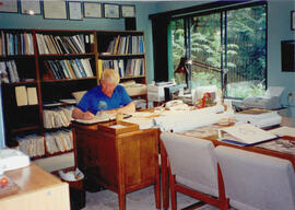
Photograph depicts Gary Runka in his Land Sense Ltd. office in Burnaby.
Item is a copy of "The Future of Animal Production in Canada", a Klinck Lecture by Dr. W.D. Morrison at Agriculture Institute of Canada.
File consists of records created and accumulated by Gary Runka over the course of his consultancy work for Angelus Ventures Ltd. for the "Delta Community Plan" project in Delta. This file was numbered as G.G. Runka Land Sense Ltd. client file #138; that client number may be seen referenced elsewhere in the G. Gary Runka fonds. The Land Sense Ltd. client files generally include records such as correspondence, contracts, invoices, project reports, publications, ephemera, memoranda, maps or map excerpts, legal documents, meeting materials, clippings, and handwritten notes.
File consists of original copies of Agricultural Land Commission statistical reports for the British Columbia Agricultural Land Reserve. Includes reports for: 1985, 1986, 1987, 1988, 1989, 1993, 1994, 1996, 1997.
File consists of records created and accumulated by Gary Runka over the course of his consultancy work for Community & Regional Planning, UBC for the "Course Director: Natural Resource Management for Indian Band Planning" project in Vancouver. This file was numbered as G.G. Runka Land Sense Ltd. client file #129; that client number may be seen referenced elsewhere in the G. Gary Runka fonds. The Land Sense Ltd. client files generally include records such as correspondence, contracts, invoices, project reports, publications, ephemera, memoranda, maps or map excerpts, legal documents, meeting materials, clippings, and handwritten notes.
File consists of records created and accumulated by Gary Runka over the course of his consultancy work for Transport Canada for the "Drainage and Integrated Land Use Investigation - Boundary Bay Airport" project in Vancouver. This file was numbered as G.G. Runka Land Sense Ltd. client file #131; that client number may be seen referenced elsewhere in the G. Gary Runka fonds. The Land Sense Ltd. client files generally include records such as correspondence, contracts, invoices, project reports, publications, ephemera, memoranda, maps or map excerpts, legal documents, meeting materials, clippings, and handwritten notes. File also includes an accompanying oversize aerial photograph.
File consists of records created and accumulated by Gary Runka over the course of his consultancy work for Parson Watershed Alliance for the "Consultation on Watershed Use Conflict Resolution" project in Parson. This file was numbered as G.G. Runka Land Sense Ltd. client file #133; that client number may be seen referenced elsewhere in the G. Gary Runka fonds. The Land Sense Ltd. client files generally include records such as correspondence, contracts, invoices, project reports, publications, ephemera, memoranda, maps or map excerpts, legal documents, meeting materials, clippings, and handwritten notes.
File consists of records created and accumulated by Gary Runka over the course of his consultancy work for Urban Systems Ltd. for Westbank Indian Band for the "Westbank Indian Band Agricultural Community Plan - Mission Creek Site" project in Kelowna. This file was numbered as G.G. Runka Land Sense Ltd. client file #140; that client number may be seen referenced elsewhere in the G. Gary Runka fonds. Includes correspondence, invoices, memoranda, photocopied map areas, terms of reference, and handwritten notes. File also includes 2 accompanying aerial photographs.
Includes the following:
- G. G. Runka Land Sense Ltd., "Draft Explanatory Notes to Accompany Mapping - Westbank Indian Band - Agricultural Community Plan - Mission Creek Site - Land Capability for Agriculture, Land Suitability for Agriculture, Hazard Lands and Geo-technical Considerations", July 1985
- Arcus Consulting Ltd. for G. G. Runka Land Sense Ltd., "The Agricultural Development of the Tsinstikeptum Indian Reserve 7: Economic Considerations", August 1985
- "Grazing Area - Grazing Licence - Mission Creek C.R.M.P.", January 1985
- "Tsinstikeptum Indian Reserve 7: Land Capability for Agriculture", Urban Systems Ltd., 1995;
- "Tsinstikeptum Indian Reserve 7: Land Suitability for Agriculture", Urban Systems Ltd., 1995;
- "Tsinstikeptum Indian Reserve 7: Areas of Geotechnical Concern", Urban Systems Ltd., 1995;
- "Tsinstikeptum Indian Reserve 7: Proposed Farm Units", Urban Systems Ltd., 1995;
- [Tsinstikeptum Indian Reserve 7?] photomap, [1995?].
File consists of records created and accumulated by Gary Runka over the course of his consultancy work for Municipality of Summerland for the "Irrigation Suitability of Lands not Currently Allocated Irrigation - Summerland Official Community Plan Review" project in Summerland. This file was numbered as G.G. Runka Land Sense Ltd. client file #145; that client number may be seen referenced elsewhere in the G. Gary Runka fonds. The Land Sense Ltd. client files generally include records such as correspondence, contracts, invoices, project reports, publications, ephemera, memoranda, maps or map excerpts, legal documents, meeting materials, clippings, and handwritten notes.
File consists of records created and accumulated by Gary Runka over the course of his consultancy work for BC Buildings Corporation for the "Land Resource Inventory of Tranquille Institution" project in Kamloops. This file was numbered as G.G. Runka Land Sense Ltd. client file #149; that client number may be seen referenced elsewhere in the G. Gary Runka fonds. The Land Sense Ltd. client files generally include records such as correspondence, contracts, invoices, project reports, publications, ephemera, memoranda, maps or map excerpts, legal documents, meeting materials, clippings, and handwritten notes. File also includes 4 accompanying aerial photographs (2 with overlays) and 1 photographic print. Includes report by G. G. Runka Land Sense Ltd. for B.C. Buildings Corporation entitled "Tranquille Farm, Kamloops, B.C., Land Resource Attributes and Constraints", January 1986.
Maps include:
- British Columbia Buildings Corporation, "Tranquille School & Farm", Aug. 1979
- British Columbia Buildings Corporation, "Tranquille", Feb. 1980
- British Columbia Buildings Corporation, "Tranquille Wasterwater Management System Upgrading", Feb. 1981 (2 copies)
- R. B. Stothers, City of Kamloops, "Posting Plan of Outer Boundaries of DL 341,342 & 343 all of Group 1 KDYD; LS6,11 & 12 of Sec 25; and NW Cor Sec 25, TP 20 Rge 19 W6M KDYD, Dec. 1985 (3 copies, 1 of which is annotated)
- Untitled map of D.L. 342 & 343 etc.
- Enlargement of Untitled map of D.L. 342 & 343 etc.
- Reproduction of [1916?] "Plan of Part of Lot 343 G1 Kamloops District"
- Reproduction of Canada Department of Agriculture Water Development Branch, "General Plan - Tranquille Farm Lands", Dec. 1953
- Annotated draft map showing Red Plateau grazing permit, Tranquille Reserve, existing fence, and proposed fence, circa [198-?]
- Reproduction of Department of Lands and Forests, "Plan of Tranquille School", Oct. 1961
- G.G. Runka Land Sense Ltd., draft mylar map negative depicting Tranquille Farm entitled "Map 1: Landforms", 1985
- G.G. Runka Land Sense Ltd., draft mylar map negative depicting Tranquille Farm entitled "Map 2: Land Capability for Agriculture", 1985
- G.G. Runka Land Sense Ltd., draft mylar map negative depicting Tranquille Farm entitled "Map 3: Land Suitability for Agriculture", 1985 (with overlays)
- G.G. Runka Land Sense Ltd., draft mylar map negative depicting Tranquille Farm entitled "Map 4: Present and Surrounding Use", 1985
- G.G. Runka Land Sense Ltd., draft mylar map negative depicting Tranquille Farm entitled "Map 5: Legal and Jurisdictional", 1985
- G.G. Runka Land Sense Ltd., draft mylar map negative depicting Tranquille Farm entitled "Map 6: Proposed Land Use and Legal Parcel Replot", 1985
- BC Ministry of Environment, 92I.078.1.4.1 Orthophoto map, Jan. 1985
- BC Ministry of Environment, 92I.078.1.4.1 Orthophoto map (reproduced with overlay), Jan. 1985
- BC Ministry of Environment, 92I.078.1.4.2 Orthophoto map, Jan. 1985
- BC Ministry of Environment, 92I.078.1.4.2 Orthophoto map (reproduced with overlay), Jan. 1985
- BC Ministry of Environment, 92I.078.1.4.4 Orthophoto map, Jan. 1985
- BC Ministry of Environment, 92I.078.2.3.1 Orthophoto map, Jan. 1985
- BC Ministry of Environment, 92I.078.2.3.1 Orthophoto map (reproduced with overlay), Jan. 1985
- BC Ministry of Environment, 92I.078.2.3.3 Orthophoto map, Feb. 1985
- Partial photocopy reduction of "Soil Map of Tranquille Sanatorium Farm", 1957 (on 2 sheets)
- Department of Lands and Forests Topographic Division Surveys & Mapping Branch, "Plan of Tranquille School" original detailed large reproduction annotated in colour, October 1961
- Large original reproduction of "Plan of Tranquille School", undated, possibly circa 1958-1961
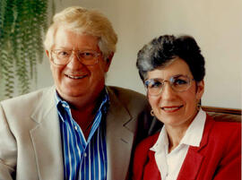
Photograph is a portrait of Gary Runka and Joan Sawicki.
Item is a copy of "Silviculture - a site degradation consideration?".
Item is a copy of "Campbell River Area Park Plan" by the Regional District of Comox Strathcona.
File consists of selected background and resource material collected by Gary Runka relating to agriculture and environment topics. Includes:
- A draft report to the Environment and Natural Resources Committee from the Agriculture and Food Task Force
- Draft appendix material for "Land Requirements for 150 Head Cow/Calf Operations" in British Columbia (excerpted from unknown report)
- Handout for Agricultural Sciences 110 Lab Section discussion on "Rural/Urban Conflicts - Who is the Culprit?" (6 Feb. 1986)
File consists of records created and accumulated by Gary Runka over the course of his consultancy work for Lornex Mining Corporation for the "Review of Environmental, Reclamation and Pollution Control Commitments - Copper Division, Cominco Ltd." project in Highland Valley. This file was numbered as G.G. Runka Land Sense Ltd. client file #158; that client number may be seen referenced elsewhere in the G. Gary Runka fonds. The Land Sense Ltd. client files generally include records such as correspondence, contracts, invoices, project reports, publications, ephemera, memoranda, maps or map excerpts, legal documents, meeting materials, clippings, and handwritten notes.
Includes the following original reports:
- G. G. Runka Land Sense Ltd. for Lornex Mining Corporation Ltd., "A Review of Environmental, Reclamation and Pollution Control Commitments - Copper Div. Cominco Ltd., Highland Valley", 1986
- Reid, Collins Nurseries Limited and G. G. Runka Land Sense Ltd. for Lornex Mining Corporation Ltd., "Reclamation and Land Use Plan - Lornex Mining Activities Area, Highland Valley - Volume I: Recommended Land Use Objectives", January 1984
- Reid, Collins Nurseries Limited and G. G. Runka Land Sense Ltd. for Lornex Mining Corporation Ltd., "Reclamation and Land Use Plan - Lornex Mining Activities Area, Highland Valley - Volume II: Reclamation Assessment and Planning", January 1984.
File consists of records created and accumulated by Gary Runka over the course of his consultancy work for Schutz and Markle for the "Location and Land Use Planning of Wilderness Lodge Site Options in Southern B.C." project in Glimpse Lake, Thalia Lake. This file was numbered as G.G. Runka Land Sense Ltd. client file #172; that client number may be seen referenced elsewhere in the G. Gary Runka fonds. The Land Sense Ltd. client files generally include records such as correspondence, contracts, invoices, project reports, publications, ephemera, memoranda, maps or map excerpts, legal documents, meeting materials, clippings, and handwritten notes.
Item is a draft of J.W. Schwab's paper for the 10th BC Soil Science Workshop (February 20-21, 1986) entitled "Mass Wasting Impacts to Forest Land: Forest Management Implication, Queen Charlotte Islands".
File consists of records created and accumulated by Gary Runka over the course of his consultancy work for McLennan Citizens Group for the "Response to Richmond Official Community Plan" project in Richmond. This file was numbered as G.G. Runka Land Sense Ltd. client file #178; that client number may be seen referenced elsewhere in the G. Gary Runka fonds. The Land Sense Ltd. client files generally include records such as correspondence, contracts, invoices, project reports, publications, ephemera, memoranda, maps or map excerpts, legal documents, meeting materials, clippings, and handwritten notes.
