Shows routes and ports of call from Smith Sound to Portland Canal including locations of many canneries and mines now no longer extent.
The map depicts the town of Kitimat and on the other side of the map there is an advertisement for Northland Shipping.
This photocopy of a 1911 pre-emptor's map depicts land parcels in the vicinity of the Fraser River, Salmon River, and Willow River in the Fort George and Peace River areas.
The map is part of an advertising pamphlet that depicts the Yellowhead Highway 16. The map highlights towns and tourist attractions along Highway 16 like Hazelton, Kitimat, Vanderhoof, Fraser Lake, Burns Lake, Fort St. James, Prince George, Terrace, and Smithers.
This 1967 centennial map depicts Canadian achievements from 1867 to 1967. The map includes over 73 moments, events, and people that have shaped Canada in the last one hundred years.
File consists of photocopies and notes relating to the boundary expansions of the city of Prince George since its incorporation. Includes a graph drawn by Kent Sedgwick regarding the addition of land and water each year of the boundary expansion and a "Proclamation" photocopy from the B.C. Gazette (23 Apr. 1953). Also includes 5 maps: "City of Prince George Boundary Expansions since Incorporation in 1915" (1979 or 1980); "City of Prince George" (Feb. 1979); "Map of Prince George" (between 1970 and 1985); "Study Area Boundaries" (Mar. 1977); and "City of Prince George" (Feb. 1972).
File consists of maps and town surveys of early Prince George. Includes various reproduced 1915 maps and surveys depicting Prince George, Central Fort George, and Fort George: "Subdivision of part of Indian Reserve no. 1 lot 343 Cariboo District BC"; "Parcel Z map 1268"; "Plan of Subdivision lot 933"; "First addition to townsite of Central Fort George"; "Subdivision of lot 1511 Cariboo District BC"; "Townsite of Fort George" map originally made by R.H. Holland; "Plan of Subdivision of lot 1426 Fort George Collins Addition"; "Plan of subdivision of lot 932 Cariboo District"; and "Plan of subdivision of part of lot 2507."
File consists of maps depicting the Salmon River Portage area.
Item is a photocopy of a topographical map published by the Grand Trunk Pacific Railway depicting Fort George and Indian Reserve No.1 and the surrounding area.
Item is an original map depicting biogeoclimatic units of the Prince George Forest Region published by the British Columbia Ministry of Forests.
Item consists of three maps pieced together to depict Anahim Lake, Bella Coola, and Quesnel in British Columbia originally published by the Department of Lands, Forests and Water Resources in Victoria B.C.
Item is an original map depicting British Columbia and its road networks, published by the Province of British Columbia Ministry of Environment.
Item is an original map depicting biogeoclimatic zones of British Columbia published by the Ministry of Forests in Victoria, British Columbia.
Item is a photocopied 1944 map depicting Fort George, published by British Columbia Department of Lands.
Item is an original 1943 pre-emptor's map of Fort George, published by the British Columbia Department of Lands.
Item is an original 1879 map depicting northern British Columbia and the Peace River Country, created by G.M. Dawson and published in Geological Survey of Canada Report B 1879-80.
Item is an original 1976 map depicting the Prince Rupert and Terrace area in British Columbia, published by the Department of Environment in Victoria, British Columbia.
Item is an original 1969 map depicting Taseko Lakes in British Columbia, published by the Department of Energy, Mines and Resources in Ottawa Canada.
Item is an original 1969 map depicting Bonaparte Lake in British Columbia, published by the Department of Energy, Mines and Resources in Ottawa Canada.
Item is an original 1969 map depicting Prince George British Columbia, published by the Department of Energy, Mines and Resources in Ottawa.
Item is an original 1986 map depicting the Peace River to Liard region of British Columbia, published by the Outdoor Recreation Council of British Columbia.
Item is an original 1980 map depicting travel and recreation across northwestern British Columbia, published by the Canadian Cartographers Ltd. in Coquitlam, BC.
Item is an original map depicting tourism in southwestern British Columbia published by the Province of British Columbia Ministry of Tourism.
Item is an original 1970 map of British Columbia with annotations of Kent's travels throughout the province highlighted in yellow. The map was originally published by the Department of Lands, Forests and Water Resources in British Columbia.
Item is an original map depicting provincial parks across northern British Columbia and was published by the British Columbia Department of Lands, Forests and Water Resources. The map includes pen marks and highlighting.
Item is an original 1983 map depicting Atnarko River in British Columbia, published by the Province of British Columbia Ministry of Environment.
Item is an original 1989 map depicting Anahim Lake in British Columbia, published by Energy Mines and Resources Canada.
Item is an original 1996 folding brochure map depicting circle tours in the Prince George area. The map was published by the Prince George Region Development Corporation.
Item is an original map depicting the city of Prince George and its parks and trails. The map was published by the City of Prince George Leisure Services.
Item is an original 1985 map depicting Red Rock area of British Columbia, published by the Department of Energy, Mines and Resources. The map includes pen markings.
Item is an original 1961 map depicting Giscome in British Columbia, published by the Army Service Establishment, R.C.E. Map includes pen markings.
Item is an original 1961 map depicting Prince George .
File consists of clippings, notes, and reproductions relating to the Central Fort George townsite. File predominantly includes Kent Sedgwick's handwritten notes regarding land plots and development of Central Fort George. Includes: a map depicting Canadian National Railway plans along Hammond Street and the Fraser River (1936) and "Central Fort George lots" map depicting lot plans for the Central Fort George townsite (reproduced 1990).
File consists of maps and aerial photographs of Prince George. Includes: "Record of gift" typed document to Kent Sedgwick (10 July 1989); "Map showing topography of the incorporated area of Prince George" reproduction of a map depicting topography and lot areas of Prince George, originally drawn 1926; BC5553 No 237" aerial photo reproduction depicting Prince George [ca. 1980]; "Prince George September 1969" aerial photo reproduction (Sept. 1969); and "3rd and Johnson" reproduction of an aerial photo depicting 3rd Avenue and Johnson St in Prince George [ca. 1970]."
Item is a hand drawn and coloured map by the City of Prince George Planning Department depicting zoning proposed by the Prince George City Planner for the VLA neighbourhood.
Item is a map depicting the Vancouver Carney study neighbourhood area in Prince George.
Item is the Proposed Land Use Map, 1978-2012, referred to in By-law No. 3138, the City of Prince George Official Community Plan. The original draft of this map was completed on October 24, 1977. This version of the map was amended in July 1982.
This map is part of Schedule B of the 1993 Official Community Plan, Bylaw No. 5909 for the City of Prince George. This particular map depicts the east area of the City of Prince George, including the Prince George Airport (YXS) and the Blackburn area.
This map is the Schedule A accompanying map for the City of Prince George's Soil Removal and Deposit Bylaw No. 7022 of 1999. It depicts designated soil removal areas and M.O.T.H. gravel reserves.
This map is Schedule C of the 2001 Official Community Plan, Bylaw No. 7281 for the City of Prince George. This Schedule C map shows the long range land use for the City of Prince George.
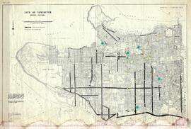
This municipal map of the City of Vancouver from 1987 shows street names and street widening information.
The map depicts the highest mountains in British Columbia; includes the Rocky Mountains, the Northern and Southern Plateaus, and the Mackenzie Mountain area.
The map is taken from the supplement of the Omineca Express/Bugle Caledonia Courier newspaper. The area map depicts highways, secondary roads, lakes, and gravel roads near Fort St. James, Stuart Lake, Fraser Lake, Fort Fraser, and Vanderhoof.


![Proposed Land Use 1978-2012, Official Community Plan, City of Prince George [1982 Amendment]](/uploads/r/northern-bc-archives-special-collections-1/6/6/9/669fc9dc3b840a6896f6a2a968a948283a3c5d972b6b48d718b427a57ebbe67f/2023.5.1.22_-_1982_-_Proposed_Land_Use_1982-2012_JPG85_tb_142.jpg)


