Affichage de 107 résultats

Archival description
102 résultats avec objets numériques Afficher les résultats avec des objets numériques
Research and Experimental Forests
2007.1.20 · Série organique · 1924-1999
Fait partie de Aleza Lake Research Forest fonds

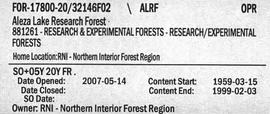
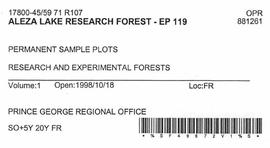
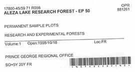
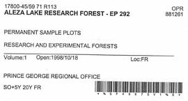
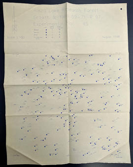
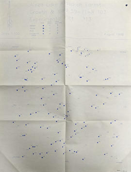
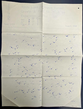
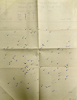
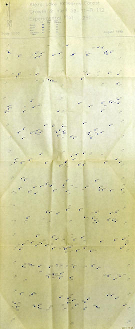
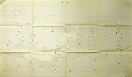
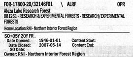
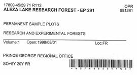
Series contains aerial photographs, stump data sheets, permanent sample plot summaries, correspondence, minutes from meetings, research proposals, budget reports, measurement charts, various historical documents, permits, field notes, overview diagrams, and an inventory of the 1994 Northwood Pulp and Timber donation to the Fraser Fort George Museum.

Aleza Lake Research Forest - Volume 2
2007.1.20.2 · Dossier · 1959-1999
Fait partie de Aleza Lake Research Forest fonds

File contains various documents pertaining to the history of the Aleza Lake Experiment Station, correspondence regarding various administrative issues and research projects ranging from 1972 to 1996, field notes, 1996 meeting minutes, memoranda containing details on the management and preservation of the Aleza Lake Research Forest, various reports on research projects, 1987 permits, field notes, a 1970 working plan, and 6 colour photographs of the Aleza Lake Garbage Dump.

Historical Info
2007.1.25 · Série organique · 1913-1998
Fait partie de Aleza Lake Research Forest fonds

Series contains historical information regarding the Aleza Lake Research Forest. Includes photographs and slides pertaining to the Aleza Lake Experiment Station.

Aleza Lake Maps
2007.1.80.1 · Dossier · 1949-1998
Fait partie de Aleza Lake Research Forest fonds

File contains datelines, small maps consisting of ecological site types, handwritten notes, overheads, terrain resource management information digital map data, and trail system maps.

2007.1.80.1.15 · Pièce · Sept. 1998
Fait partie de Aleza Lake Research Forest fonds

Map commissioned from Ministry of Forests Prince George Region from Madrone Consultants shows Aleza Lake Research Forest Management Compartments and Administrative Boundaries. Map is 1 of 6. Map shows the Aleza Lake Ecological Reserve, Natural Forest Reserve, the Special Management Area, and Riparian Management Research Area.

2007.1.80.1.20 · Pièce · Sept. 1998
Fait partie de Aleza Lake Research Forest fonds

Map commissioned from Ministry of Forests Prince George Region from Madrone Consultants shows Aleza Lake Research Forest terrain themes. Map is 6 of 6. Map shows the following types of terrain units: typic, slope, percipitous, gullied, hummocky, rocky, alluvial, and organic. Ecosystem classification and mapping by Oikos Ecological Services Ltd.

Maps
2007.1.80 · Série organique · 1949-1998
Fait partie de Aleza Lake Research Forest fonds

Series consists of cartographic materials including maps and blueprints of the Aleza Lake Research Forest. The maps reflect permanent sample plots and other study areas. The blueprints outline details for the development of a Ranger Station.

2007.1.80.1.18 · Pièce · Sept. 1998
Fait partie de Aleza Lake Research Forest fonds

Map commissioned from Ministry of Forests Prince George Region from Madrone Consultants shows an Aleza Lake Research Forest TRIM Base Map. Map is 4 of 6. Map shows the following: roads, old roads, buildings, rail line, transmission line, definite streams, intermittent streams, indefinite streams, marshes, swamps, lakes, wooded area boundaries, intermediate contour lines (20m intervals), and index contour lines (100m intervals).

2007.1.80.1.17 · Pièce · Sept. 1998
Fait partie de Aleza Lake Research Forest fonds

Map commissioned from Ministry of Forests Prince George Region from Madrone Consultants shows Aleza Lake Research Forest Access and Access Management. Map is 3 of 6. Map shows the following road types: all weather 1-lane gravel road, dry weather road, and proposed road access. Also shows areas for parking/turnaround, toilets, and information signs.

2007.1.80.1.19 · Pièce · Sept. 1998
Fait partie de Aleza Lake Research Forest fonds

Map commissioned from Ministry of Forests Prince George Region from Madrone Consultants shows Aleza Lake Research Forest ecosystems. Map is 5 of 6. Map shows many sub-types of the following ecosystem types: upland, lowland wet forest, wetlands, and the Bowron floodplain benches. Ecosystem classification and mapping by Oikos Ecological Services Ltd.

Aleza Lake Research Forest - Volume 1
2007.1.20.1 · Dossier · 1946-1998
Fait partie de Aleza Lake Research Forest fonds

File contains plot summaries of selected permanent sample plots, correspondence regarding field courses, records of management committee meetings from 1991 and 1990, documents and correspondence pertaining to the re-opening of the Aleza Lake Research Forest, partial cutting summaries, research proposals and studies, cost and revenues documents, a 1961 biography on Percy Barr, charts covering remeasurements of permanent sample plots, hand written correspondence from 1990 discussing the history of marking crews, and a brief history of the Aleza Lake Experiment Station.

Management and Working Plans
2007.1.30 · Série organique · 1927-1998, predominantly 1950-1998
Fait partie de Aleza Lake Research Forest fonds

Series contains working and management plans, a policy handbook, drafts, correspondence, proposals, recommendations, revenue records, photographs, handwritten notes, maps, and planning projects.