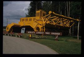
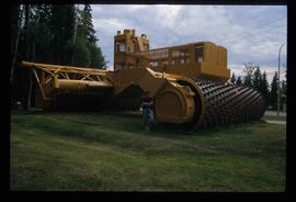
Previsualizar a impressão Fechar

Mostrar 27 resultados

Archival description
Mackenzie, BC
Previsualizar a impressão Hierarchy Ver:

24 resultados com objetos digitais Mostrar resultados com objetos digitais

Trail Maps and Recreation Guides

File consists of trail maps and recreation guides from various places in British Columbia, especially Northern British Columbia. Maps include:

  • British Columbia Road Map and Parks Guide
  • Northwood Pulp and Timber Limited Forest Operations Recreation Map
  • Provincial Parks of Northern British Columbia
  • Visitor's Guide: Mackenzie Woodlands
  • Visitors Guide: Mackenzie Woodlands
  • Mackenzie Forest District Recreation Map
  • Dawson Creek Forest District Recreation Map
  • Morice Forest District Recreation Map
  • Fort St. James Forest District Recreation Map
  • Lakes Forest District Recreation Map
  • Cariboo Forest Region Recreation Map
  • Lakes District Visitors Map
  • Prince George Forest District Recreation Map
  • Vanderhoof Forest District Recreation Map
  • Fort St. John Forest District Recreation Map
  • Cariboo Forest Region Recreation Map (East)
  • Robson Valley Forest District Recreation Map
  • Fort Nelson Forest District Recreation Map
  • Forest Service Recreation Sites: Valemount - Blue River
  • Forest Service Recreation Sites: McBride - Goat River
  • Forest Service Recreation Sites: Prince George West
  • Forest Service Recreation Sites: Moberly - Sukunka
  • Forest Service Recreation Sites: Nation - Takla
  • Forest Service Recreation Sites: Murrat - Kiskatinaw
  • Recreation Road Map for the Prince George Forest Area (1987-1988)
  • Recreation Road Map for the Prince George Forest Area (1997)
  • The Bobtail Forest Service Road Tour
  • Forest Recreation Map: Northwood Pulp and Timber Limited
  • Forest Operations Recreation Map: Northwood pulp and timber limited
  • Forest Service: Recreation Sites Williston/Mackenzie
  • Forest Service Recreation Sites Prince George West
  • The Official Prince George Tourist Street Map
  • Ecological Reserves in British Columbia (July 1990)
  • Prince George Forest District map (April 1990) with annotations regarding trials.

Helen Mustard Collection

  • 2004.24
  • Coleção
  • c.1975-c.1980

The Helen Mustard Collection consists of textual records, audiocassettes and copies of publications relating to the history of Mackenzie Townsite and Rocky Mountain Trench region of Northern British Columbia

Mackenzie Town

File contains slides depicting places in and around Mackenzie Town.

Residential Area

Image depicts a residential area with a playground somewhere in Mackenzie, B.C.

Mackenzie Curling Rink

Image depicts a small section of Mackenzie, with the Mackenzie Curling Rink visible on the right side of the image.

Mackenzie - Morfee Lake

Image depicts the frozen Morfee Lake just to the East of Mackenzie, B.C. The slide is also labelled "sub-boreal," referencing that it is a sub-boreal spruce zone.

Mackenzie Centre

Image depicts numerous vehicles parked outside a building with a sign which reads "Mackenzie Centre;" it is possibly the mall in Mackenzie, B.C.

Mackenzie - Meeting

Image depicts numerous individuals examining a map as they are seated around a table. The location of the meeting is somewhere in Mackenzie, B.C.

Mackenzie - Meeting

Image depicts numerous individuals seated around a table and apparently having a meeting at an uncertain location in Mackenzie, B.C.

Mackenzie - Mall

Image depicts numerous individuals inside a mall in Mackenzie, B.C.