Showing 658 results
Archival description
"Map of Northern British Columbia and the Peace River Country"
"Map of Northern British Columbia and the Peace River Country"
"Map of Plant Hardiness Zones in Canada"
"Map of Plant Hardiness Zones in Canada"
"Map of Prince Rupert"
"Map of Prince Rupert"
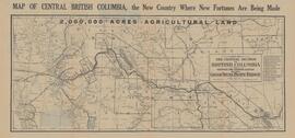
"Map of the Central Section of British Columbia Shewing the Country Served by the Grand Trunk Pacific Railway"
"Map of the Central Section of British Columbia Shewing the Country Served by the Grand Trunk Pacific Railway"
Map showing locations of placer streams in British Columbia south of latitude 54 degrees North, with Queen Charlotte Islands inset in north east corner
Map showing locations of placer streams in British Columbia south of latitude 54 degrees North, with Queen Charlotte Islands inset in north east corner
"Map showing topography of the incorporated area of Prince George"
"Map showing topography of the incorporated area of Prince George"
Maps
Maps
Maps
Maps
Maps
Maps
Maps
Maps
Maps
Maps
Maps & Oversize
Maps & Oversize
Maps and aerial photographs of Prince George
Maps and aerial photographs of Prince George
Maps and plans
Maps and plans
Maps and plans
Maps and plans
Maps series
Maps series
Maps, Plans and Technical Drawings
Maps, Plans and Technical Drawings
Maps, plans, and drawings
Maps, plans, and drawings
Maps, posters and plans
Maps, posters and plans
Mark Clark Forestry Collection
Mark Clark Forestry Collection
McBride, B.C. Map
McBride, B.C. Map
"McLeod Lake, British Columbia" 1969 map
"McLeod Lake, British Columbia" 1969 map
McNaughton Lake, B.C. Map
McNaughton Lake, B.C. Map
"Meyers Flat & Swamp Uranium Content"
"Meyers Flat & Swamp Uranium Content"
"Mineral and Coal Strategic Economic Development Plan North West British Columbia"
"Mineral and Coal Strategic Economic Development Plan North West British Columbia"
Mineral Deposit - Land Use Map
Mineral Deposit - Land Use Map
Mineral Deposit-Land Use Map
Mineral Deposit-Land Use Map
Mining in the Cariboo
Mining in the Cariboo
Miscellaneous material
Miscellaneous material
"Mount Waddington, British Columbia" 1969 map
"Mount Waddington, British Columbia" 1969 map
"Mount Waddington, British Columbia" 1984 map
"Mount Waddington, British Columbia" 1984 map
"Mr. P.G. says Welcome to the City of Prince George"
"Mr. P.G. says Welcome to the City of Prince George"
"Nass River, British Columbia" 1972 map
"Nass River, British Columbia" 1972 map
"Native Lands then and now"
"Native Lands then and now"
Nechako Fisheries Conservation Program
Nechako Fisheries Conservation Program
"Nechako River / Isle Pierre"
"Nechako River / Isle Pierre"
North American and Australian indigenous knowledge and science
North American and Australian indigenous knowledge and science
"North Coast LRMP G2G Outcomes - Proposed Final Zoning - December 2005"
"North Coast LRMP G2G Outcomes - Proposed Final Zoning - December 2005"
