Title and statement of responsibility area
Title proper
General material designation
Cartographic material
Parallel title
Other title information
Title statements of responsibility
Title notes
- Source of title proper: Title based on subject
Level of description
Reference code
Edition area
Edition statement
Edition statement of responsibility
Class of material specific details area
Statement of scale (cartographic)
Statement of projection (cartographic)
Statement of coordinates (cartographic)
Statement of scale (architectural)
Issuing jurisdiction and denomination (philatelic)
Dates of creation area
Date(s)
-
20 Sept. 1926-19 Oct. 1926 (Creation)
Physical description area
Physical description
1 photograph : b&w ; 16.5 x 21.5 cm
Publisher's series area
Title proper of publisher's series
Parallel titles of publisher's series
Other title information of publisher's series
Statement of responsibility relating to publisher's series
Numbering within publisher's series
Note on publisher's series
Archival description area
Custodial history
Scope and content
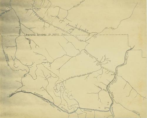
Map depicts the rivers, railways, and select lakes and towns located at Jasper Park between the northern boundary of the park and the townsite of Jasper. Part of the border between Alberta and British Columbia is visible on the west of the map.
Notes area
Physical condition
Immediate source of acquisition
Arrangement
Language of material
English
Script of material
Location of originals
Availability of other formats
Restrictions on access
No restrictions.
Terms governing use, reproduction, and publication
Personal or academic use of materials is welcomed under the standard fair dealing and educational use clauses of Canadian Copyright Law. Commercial use is, however, forbidden without the express permission of the copyright holder. For information on obtaining written permission from the copyright holder, please contact the Northern B.C. Archives and Special Collections.
Finding aids
Associated materials
Accruals
General note
General note
Photo of map featured on page 120 of "From the Peace to the Fraser: Newly Discovered North American Hunting and Exploration Journals, 1900 to 1930" by Prentiss Gray. Metadata Elements for scanned image: Spatial Resolution - 570 dpi (master image); Signal Resolution - 8-bit colour channel ; Colour Mode - RGB ; File Format - .tif (master); .jpeg (derivative); Storage Medium - .tif (master) on Gold Mitsui CDRs and external hard drive ; .jpeg (derivative) on SQL server ; Scanning Equipment - Microtek Scanmaker 9800XL; Scanning Date - November 2008.
General note
Photographer: Prentiss Gray
Conservation
Photo emulsion is yellowing and image is beginning to fade; silvering is also evident.