Previsualizar a impressão Fechar
Mostrar 4134 resultados
Archival description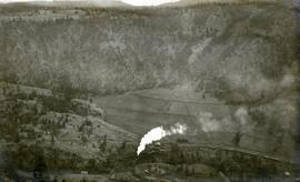
Pacific Great Eastern Railway train on Pavilion Creek trestle
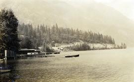
Alta Lake
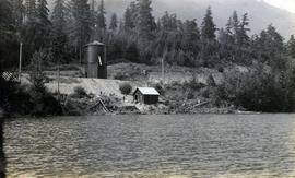
Alta Lake water tower and rail line at lake shore
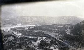
Pacific Great Eastern Railway line at Pavilion
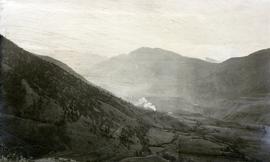
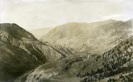
View of Cayoosh Creek
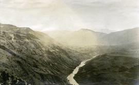
Moran Canyon near Lillooet
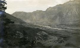
View of Lillooet Indian Reserve and town
Lillooet area?
Maps & Oversize
Maps & Oversize

"British Columbia's Skeena Salmon"
"Agriculture, Fish & Food in B.C."
"Agriculture, Fish & Food in B.C."
"Vancouver Island's Forests"
"Vancouver Island's Forests"
"Energy Resources of British Columbia"
"Energy Resources of British Columbia"
"Areas Alienated or Restricted from Mining in British Columbia 1983"
"Areas Alienated or Restricted from Mining in British Columbia 1983"
"Southeastern British Columbia Coal Properties and Geology"
"Southeastern British Columbia Coal Properties and Geology"
"Comox & Nanaimo Coalfields Properties and Geology"
"Comox & Nanaimo Coalfields Properties and Geology"
"Groundhog Coalfield Properties and Geology"
"Groundhog Coalfield Properties and Geology"
"Mineral and Coal Strategic Economic Development Plan North West British Columbia"
"Mineral and Coal Strategic Economic Development Plan North West British Columbia"
"Producing Mines and Significant Mineral and Coal Deposits of British Columbia"
"Producing Mines and Significant Mineral and Coal Deposits of British Columbia"
"Super Crop Forage Seeds for B.C."
"Super Crop Forage Seeds for B.C."
"B.C.'s Endangered Wilderness: A Comprehensive Proposal for Protection"
"B.C.'s Endangered Wilderness: A Comprehensive Proposal for Protection"
"North Coast LRMP G2G Outcomes - Proposed Final Zoning - December 2005"
"North Coast LRMP G2G Outcomes - Proposed Final Zoning - December 2005"
"Habitat Types and Terrain Assessment of the Columbia River Marshes"
"Habitat Types and Terrain Assessment of the Columbia River Marshes"
"Central Coast Regional District (CCRD) - Canada Thistle, Common Tansy, Diffuse Knapweed, Hawkweed spp, Curled Dock, English Ivy, Knotweeds"
"Central Coast Regional District (CCRD) - Canada Thistle, Common Tansy, Diffuse Knapweed, Hawkweed spp, Curled Dock, English Ivy, Knotweeds"
"Central Coast Regional District (CCRD) - Blueweed, Broadleaf Plantain, Bull Thistle and Burdock"
"Central Coast Regional District (CCRD) - Blueweed, Broadleaf Plantain, Bull Thistle and Burdock"
"Central Coast Regional District (CCRD) - Scentless Chamomile, Sheep Sorrel, Spotted Knapweed, St Johns Wort, Thistle spp, Water Hemlock, Western Goats beard, Wildlife Mustard, Yellow Toadflax"
"Central Coast Regional District (CCRD) - Scentless Chamomile, Sheep Sorrel, Spotted Knapweed, St Johns Wort, Thistle spp, Water Hemlock, Western Goats beard, Wildlife Mustard, Yellow Toadflax"
"Bella Coola area Invasive Plants Distribution as per IAPP data - Feb. 19"
"Bella Coola area Invasive Plants Distribution as per IAPP data - Feb. 19"
"Okanagan Connector"
"Okanagan Connector"
"Cariboo-Chilcotin Existing Tourism Use"
"Cariboo-Chilcotin Existing Tourism Use"
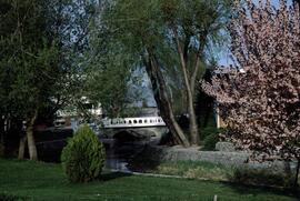
Kelowna park entrance
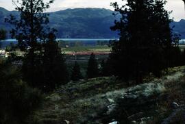
Mount Boucherie orchards
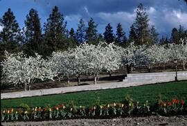
Tulips and cherry blossom trees
Print Photographs
Print Photographs

Aerial photograph of West Coast Trail at Tsusiat Falls

Aerial photograph of West Coast Trail at Tsusiat Falls

Aerial photograph of West Coast Trail at Tsusiat Point Hole in the Wall

Aerial photograph of West Coast Trail at Nitinat Narrows

Aerial photograph of West Coast Trail at Carmanah Lighthouse
UNBC School of Planning and Sustainability fonds
UNBC School of Planning and Sustainability fonds
Maps, plans, and drawings
Maps, plans, and drawings

North Nechako Existing Land Use

Hart Highway Existing Land Use

College Heights-Southwest Existing Land Use

North Nechako-Hart Proposed Land Use

Blackburn Development Area Proposed Sector Plan

V.L.A. Proposed Zoning

V.L.A. Record of Public Representations at Zoning Hearing, April 12, 1976

V.L.A. Proposed Zoning as Recommended by Alderman A. Stauble, April 20, 1976

V.L.A. Proposed Zoning as Recommended by the City Planner, April 20, 1976

Van Bow Existing Land Use 1976