Title and statement of responsibility area
Title proper
General material designation
Cartographic material
Parallel title
Other title information
Title statements of responsibility
Title notes
Level of description
Reference code
Edition area
Edition statement
Edition statement of responsibility
Class of material specific details area
Statement of scale (cartographic)
Statement of projection (cartographic)
Statement of coordinates (cartographic)
Statement of scale (architectural)
Issuing jurisdiction and denomination (philatelic)
Dates of creation area
Date(s)
-
11 June 1976 (Creation)
Physical description area
Physical description
1 map : ms., hand col.
Publisher's series area
Title proper of publisher's series
Parallel titles of publisher's series
Other title information of publisher's series
Statement of responsibility relating to publisher's series
Numbering within publisher's series
Note on publisher's series
Archival description area
Custodial history
Scope and content
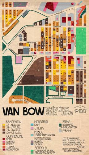
Item is a hand drawn and coloured map by the City of Prince George Planning Department depicting existing land use for the Van Bow neighbourhood area.
Notes area
Physical condition
Map is worn and torn around edges. Some tearing has been repaired.
Immediate source of acquisition
Arrangement
Language of material
English
Script of material
Location of originals
Availability of other formats
Item has been digitized and is available in JPG and TIFF format. Item is still in copyright; a representative image thumbnail is provided only. For full quality reproductions for research use only, please contact archives@unbc.ca
Restrictions on access
No restrictions.
Terms governing use, reproduction, and publication
Personal or academic use of materials is welcomed under the standard fair dealing and educational use clauses of Canadian Copyright Law. Commercial use is forbidden without the express permission of the copyright holder.
