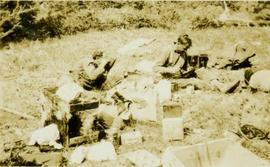
Showing 56226 results

Archival description
23670 results with digital objects Show results with digital objects
Whitney Smith
1996.2.1.1.582 · File · 1973-1994 ; predominant 1986-1988
Part of Brian Fawcett fonds

File contains correspondence to Brian Fawcett from Whitney Smith. Includes letters to Brian Fawcett from Whitney Smith of the Society For The Conservation Of Wild Culture. Letters predominately written 1986 to 1988.

Whitehorse Runway
2006.20.12.39 · Item · [ca. 1940]
Part of Northern BC Archives Historical Photograph Collection

Handwritten photo album caption below this photo reads: "Whitehorse 'Runway'". Photograph depicts three planes in distance on runway, one of them is parked in front of large building on left (hangar?). Two long unidentified buildings in background on left, trees and range of hills in background on right. See also items 2006.20.12.1 & 2006.20.12.43.

Royal Canadian Air Force
Whitehorse below
Item · 7/1/1970
Part of Mary Fallis fonds

Aerial view, Alpine Club of Canada's 1967 Yukon Alpine Centennial Expedition, Kluane National Park, Yukon

Whitecap Books Ltd.
1996.2.1.1.656 · File · 1991
Part of Brian Fawcett fonds

File contains correspondence to Brian Fawcett from Whitecap Books Ltd.. Includes a letter to Brian Fawcett from Colleen MacMillan, Publisher of Whitecap Books Ltd., regarding his deadline for reviews on gardening titles. Letter dated April 18, 1991.

White, Isobel
2002.14.1.09.088 · File · 2002
Part of Marianne (Marika) Ainley fonds

File consists of biographical information and research materials about Australian anthropologist, Isobel White.

White, Don
1996.2.11.1.45 · File · [between 1980 and 2006]
Part of Brian Fawcett fonds

File consists of "Take Paradise" by Don White.

2023.2.2.13.2.03 · Item · 8 Jul. 2007
Part of Dr. Paul Sanborn fonds

This image is part of the outbound sequence of aerial images obtained on the helicopter flight to the Klutlan Glacier study site. The sequence starts from the base camp at the White River crossing on the Alaska Highway and heads south, to a point just upvalley of the debris-covered terminus (approx. 10-15 km from Alaska border), and turning back north to the landing spot on the Generc River floodplain close to the study site (see Fig. 1 in paper).

2023.2.2.13.2.06 · Item · 8 Jul. 2007
Part of Dr. Paul Sanborn fonds

This image is part of the outbound sequence of aerial images obtained on the helicopter flight to the Klutlan Glacier study site. The sequence starts from the base camp at the White River crossing on the Alaska Highway and heads south, to a point just upvalley of the debris-covered terminus (approx. 10-15 km from Alaska border), and turning back north to the landing spot on the Generc River floodplain close to the study site (see Fig. 1 in paper).

2023.2.2.13.2.05 · Item · 8 Jul. 2007
Part of Dr. Paul Sanborn fonds

This image is part of the outbound sequence of aerial images obtained on the helicopter flight to the Klutlan Glacier study site. The sequence starts from the base camp at the White River crossing on the Alaska Highway and heads south, to a point just upvalley of the debris-covered terminus (approx. 10-15 km from Alaska border), and turning back north to the landing spot on the Generc River floodplain close to the study site (see Fig. 1 in paper).

2023.2.2.13.2.02 · Item · 8 Jul. 2007
Part of Dr. Paul Sanborn fonds

This image is part of the outbound sequence of aerial images obtained on the helicopter flight to the Klutlan Glacier study site. The sequence starts from the base camp at the White River crossing on the Alaska Highway and heads south, to a point just upvalley of the debris-covered terminus (approx. 10-15 km from Alaska border), and turning back north to the landing spot on the Generc River floodplain close to the study site (see Fig. 1 in paper).

2023.2.2.13.2.01 · Item · 8 Jul. 2007
Part of Dr. Paul Sanborn fonds

This image is part of the outbound sequence of aerial images obtained on the helicopter flight to the Klutlan Glacier study site. The sequence starts from the base camp at the White River crossing on the Alaska Highway and heads south, to a point just upvalley of the debris-covered terminus (approx. 10-15 km from Alaska border), and turning back north to the landing spot on the Generc River floodplain close to the study site (see Fig. 1 in paper).

2023.2.2.13.2.71 · Item · 9 Jul. 2007
Part of Dr. Paul Sanborn fonds

This image is part of the return trip sequence of aerial images obtained on the helicopter flight leaving the Klutlan Glacier study site. On the return leg at the end of the day, the flight initially went upvalley to pick up another party. This image was taken after the helicopter turned north to return to base camp.

2023.2.2.13.2.74 · Item · 9 Jul. 2007
Part of Dr. Paul Sanborn fonds

This image is part of the return trip sequence of aerial images obtained on the helicopter flight leaving the Klutlan Glacier study site. On the return leg at the end of the day, the flight initially went upvalley to pick up another party. This image was taken after the helicopter turned north to return to base camp.

2023.2.2.13.2.75 · Item · 9 Jul. 2007
Part of Dr. Paul Sanborn fonds

This image is part of the return trip sequence of aerial images obtained on the helicopter flight leaving the Klutlan Glacier study site. On the return leg at the end of the day, the flight initially went upvalley to pick up another party. This image was taken after the helicopter turned north to return to base camp.

2023.2.2.13.2.72 · Item · 9 Jul. 2007
Part of Dr. Paul Sanborn fonds

This image is part of the return trip sequence of aerial images obtained on the helicopter flight leaving the Klutlan Glacier study site. On the return leg at the end of the day, the flight initially went upvalley to pick up another party. This image was taken after the helicopter turned north to return to base camp.

2023.2.2.13.2.76 · Item · 9 Jul. 2007
Part of Dr. Paul Sanborn fonds

This image is part of the return trip sequence of aerial images obtained on the helicopter flight leaving the Klutlan Glacier study site. On the return leg at the end of the day, the flight initially went upvalley to pick up another party. This image was taken after the helicopter turned north to return to base camp.

2023.2.2.13.2.73 · Item · 9 Jul. 2007
Part of Dr. Paul Sanborn fonds

This image is part of the return trip sequence of aerial images obtained on the helicopter flight leaving the Klutlan Glacier study site. On the return leg at the end of the day, the flight initially went upvalley to pick up another party. This image was taken after the helicopter turned north to return to base camp.

White River west bank
2023.2.2.13.2.04 · Item · 8 Jul. 2007
Part of Dr. Paul Sanborn fonds

This image is part of the outbound sequence of aerial images obtained on the helicopter flight to the Klutlan Glacier study site. The sequence starts from the base camp at the White River crossing on the Alaska Highway and heads south, to a point just upvalley of the debris-covered terminus (approx. 10-15 km from Alaska border), and turning back north to the landing spot on the Generc River floodplain close to the study site (see Fig. 1 in paper).

"White Pelican"
2000.6.04.3.197 · File · 1971-1974
Part of Barry McKinnon fonds

File consists of issues of the literary periodical entitled "White Pelican", including volume 1 issue 1 through volume 4 issue 1 (incomplete).

White Pass Train
2012.13.1.100 · Subseries · 1999
Part of J. Kent Sedgwick fonds

File contains slides depicting locations along the White Pass railway through Alaska, British Columbia, and the Yukon Territories.

White Pass & Yukon Railway
2013.6.26 · Series · 1975-2013
Part of David Davies Railway Collection

Series consists of material regarding the White Pass and Yukon Route, a narrow gauge railway that links Skagway and Whitehorse. Includes monographs about the history of the railway.

White Pass & Yukon Railway
2013.6.26.1 · File · 1982-2013
Part of David Davies Railway Collection

File consists of research material regarding the White Pass & Yukon Railway. Predominantly consists of photocopy reproductions, excerpts from books, and clippings from periodicals. Includes the following works: "A Trip on the White Pass & Yukon Route - 1994" by Lacey; "White Pass' New Gold" by Zimmerman; "Taku Tramway, 1900 to 1937: BC's Shortest 'Short Line' Railway at 2.3 Miles" by Davies; "The White Pass & Yukon Route" by MacBride; "America's Only Modern Narrow Gauge: White Pass & Yukon has Revamped Everything But Its Gauge" by Morgan; "Canada's Newest Steam Operation" by Meldrum; "The WP&YR's Lewis Lake Disaster: an 1899 Engineering Blunder" by Johnson; "Gold Rush Line" by Bruce West; "The Amazing White Pass - Part Two: Riding the Mixed to Whitehorse and Back" by D'Amanto; "White Pass & Yukon Route and the Ton of Gold Special"; "The 'New' White Pass & Yukon Route: Will It Be Standard-Gauged?" by Johnson; "White Pass Storms to New Passenger Records" by Johnson; "White Pass Centennial: One Hundred Years and Getting Better" by Nicklason; "WY&PR's Yukon Adventure Train Reaches Carcross" by Johnson and Cooper; and "When the US Army Took Over the White Pass" by Douglas N.W. Smith.

White Pass - Mountain Side
2012.13.1.100.12 · Item · 1999
Part of J. Kent Sedgwick fonds

Image depicts a mountain side somewhere along the White Pass railway. The thin ridge along the mountain side is possibly either a highway or part of the railway.

White Pass - Mountain Side
2012.13.1.100.11 · Item · 1999
Part of J. Kent Sedgwick fonds

Image depicts a mountain side somewhere along the White Pass railway. The thin ridge along the mountain side is possibly either a highway or part of the railway.

2009.6.13.42.036 · File · 1979
Part of The Honourable Iona Campagnolo fonds

File consists of a memorandum to Campagnolo regarding a green paper on fitness and recreation, and a white paper on sport. Also includes a draft containing the objectives for the white paper on sport, a report by Campagnolo on the future of sports in Canada, a draft plan concerning sport and recreation entitled "A National Plan for Sport," and notes.