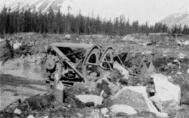
Photograph depicts track loader moving dirt in cleared area. It is believed that the loader may have been excavating area for ore haul truck dump (see item 2000.1.1.2.222). Trees and mountains in background.
Photograph was taken facing down a narrow, snowy trench, mountain base visible at end. Corresponding note on accompanying photo description page: "1. Trench through snow banks at mill site. We had to dig these trenches to facilitate surveying the mill foundations."
File consists of a paper titled "Managing Canada's North: The Case of the Provincial North" presented by Weller at the seminar "Managing Canada's North: Challenges and Opportunities" held by the Institute of Public Administration of Canada as well as copies of the paper printed for the seminar in English and French. This file was originally numbered to correspond with conference paper number 26 listed in Weller's CV.
Image depicts Manson Creek, B.C.
File contains slides depicting places in and around Manson Creek.
Image depicts a man and his family filling up their truck with gas at Manson Creek, B.C.
Image depicts the gas station at Manson Creek, B.C.
Image depicts a creek with a half collapsed shack in the background somewhere in Manson Creek. The slide is labelled "Manson workings."
Image depicts the road to Manson Creek, B.C.
Photograph of the Prince Rupert wharf. Many vessels are docked next to small buildings along the water. Annotation on recto reads: "Prince Rupert BC."
Footage from a small plane overlooking the landscape of what is believed to be either the Bella Coola Valley, Tweedsmuir Provincial Park, Rainbow Mountains, or Chilcotin area.
Footage of hunting party setting up camp in the high country of the mountains. There is a herd of caribou and footage of caribou trophy kill. There is filming of two marmots and additional recordings of camp cooking and socializing.
The film ends with the hunters entering the plane again and returning to their original camp, believed to be Nimpo lake.
Film begins with short introduction of girl pointing to a map and drawing a line to where the men will be hunting.
Footage from a small plane overlooking the landscape of what is believed to be either the Bella Coola Valley, Tweedsmuir Provincial Park, Rainbow Mountains, or Chilcotin area.
Footage of hunting party setting up camp in the high country of the mountains. There is a herd of caribou and footage of caribou trophy kill. There is filming of two marmots and additional recordings of camp cooking and socializing.
The film ends with the hunters entering the plane again and returning to their original camp, believed to be Nimpo lake.
Map depicts the rivers, railways, and select lakes and towns located at Jasper Park between the northern boundary of the park and the townsite of Jasper. Part of the border between Alberta and British Columbia is visible on the west of the map.
File consists of correspondence between Louise de Kiriline Lawrence and Margaret Morse Nice relating to ornithology publications, the community of ornithologists, and a variety of personal topics. File also includes correspondence between William Rowan and Nice relating to ornithology and the Brewster Medal for 1937.
File consists of research materials regarding Margaret Morse Nice, including photocopied letters, pamphlet by Margaret Morse Nice, and handwritten notes. File also contains a photo of Elizabeth M. Parnis and her CV.
File consists of a paper and accompanying notes delivered at the 12th International Conference of Historical Geographers in Auckland, New Zealand in 2003. The paper is entitled "Marginal landscapes of science? Gender, environments and colonial encounters in 19th and 20th century Australia, Canada, and New Zealand."
Fonds predominately reflects Ainley's research as a professor at the University of Northern British Columbia. Her research is arranged into thirteen subseries. Research material includes: photocopies of publications and archival material, correspondence, bibliographies, research interviews, transcripts, draft manuscripts, photographs, and other records. A series of personal records includes: retirement activities, her hobbies of art and writing, diplomas, and photographs. The series on her administrative and supervisory activities of professorship of women’s studies and environmental studies is arranged according to the major activities with which Ainley was involved and includes: meeting minutes, memoranda, reports, correspondence, employment, and other records. A series of electronic records relating, predominately, to Ainley’s research includes: draft manuscripts, conference proceedings, bibliographies, transcripts, correspondence, curricula vitae and other records. A series of professional development records includes records from conferences she attended and occasionally presented at as well as other professional development activities that she undertook. A series of correspondence predominantly consists of personal correspondence but also includes professional correspondence related to her research and occupation.
Ainley, MarianneAnnotation on slide: "Marked-to-cut tree with old scar, Summit selection trial".
No annotation on slide.
File contains an original BC Forest Service report for E.P. 443 by S. Benteli entitled "Marking of Douglas Fir: A Preliminary Investigation of the Problems, Restricted to Interior Dry Types and the Cariboo".
File contains material relating to the submission and editing of Ainley's chapter, "Marriage and Scientific Work in Twentieth-Century Canada: the Berkeleys in Marine Biology and the Hoggs in Astronomy" in "Creative Couples in the Sciences" about the experiences of two scientific couples: Edith and Cyril Berkeley and Frank and Helen Hogg. File consists of correspondence, edited manuscripts, permissions form templates and a call and instructions for submissions.
File consists of the following photocopied articles:
- "Collecting Plants Beyond the Frontier in Northern British Columbia" by Mary Gibson Henry
- "Exploring and Plant Collecting in Northern British Columbia" (1933) by Mary Gibson Henry
- "A Thousand Miles Exploring on Horseback in Northern British Columbia" (1935) by Mary Gibson Henry
Photograph depicts Mary John wearing flower print dress in cut field. Hay bales, trees, and fence in background.
Image depicts several houses in McBride, B.C. A mountain is visible in the background.
Image depicts a view of what is either the Rocky Mountains or possibly the Columbia Mountains from McBride, B.C.
Image depicts a view of what is either the Rocky Mountains or possibly the Columbia Mountains in the background of a small section of McBride, B.C.
File contains slides depicting places in and between McBride and the Yellowhead Pass via the Yellowhead Highway.
Image depicts the McBride Hotel near the Mt. Robson Provincial Park.
Image depicts a view of the Herrick River in what is possibly McGregor Canyon; the slide is simply labelled "McG above Canyon."
Image depicts a view of the Herrick River in what is possibly McGregor Canyon; the slide is simply labelled "McG Canyon."
Image depicts a view of the Herrick River in what is possibly McGregor Canyon; the slide is simply labelled "McG above Canyon."
Image depicts a view of the Herrick River in what is possibly McGregor Canyon; the slide is simply labelled "McG Canyon - above Herrick."
Image depicts the McGregor River at an uncertain location.
Image depicts what is possibly the McGregor River.
Image depicts the McGregor River at an uncertain location.
Image depicts a bridge over the McGregor River. A sign in the image reads: "Danger. The river is not navigable for any type of boat. Down stream falls and rapids impassible!"
Image depicts a bridge over the McGregor River.
Image depicts the McGregor from the point of view of a bridge.
Forest cover map showing a crossing area of the McGregor River is annotated with a road and ferry crossing.
File contains slides depicting the McGregor River and its surrounding areas.
Image depicts a view of McGregor Valley from an uncertain location.
Image depicts a view of McGregor Valley.
Image depicts a view of the McGregor Valley.