Showing 658 results

Archival description
236 results with digital objects Show results with digital objects
2020.4.6.360 · File · 1993-1994
Part of G. Gary Runka fonds

File consists of records created and accumulated by Gary Runka over the course of his consultancy work for BC Commission on Resources and Environment (CORE) for the "Mediation of Regional Land Use Plan - East Kootenay Table" project in East Kootenay. This file was numbered as G.G. Runka Land Sense Ltd. client file #360; that client number may be seen referenced elsewhere in the G. Gary Runka fonds. The Land Sense Ltd. client files generally include records such as correspondence, contracts, invoices, project reports, publications, ephemera, memoranda, maps or map excerpts, legal documents, meeting materials, clippings, and handwritten notes. File also includes an accompanying 3.5 inch floppy disk and audio recordings of meetings.

Includes the following:

  • West Kootenay-Boundary and East Kootenay Land Use Plans. Explanation of the Methodology Used to Complete the Impact Analysis. Commission on Resources and Environment. 1995.
  • East Kootenay Land Use Plan and Summary Report. Commission on Resources and Environment. Victoria, BC. October 1994 and March 1995.
  • Conserving Working Landscapes: A Framework for Conservation on Private Land. East Kootenay Conservation Program. Undated.
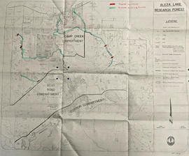
Maps include:

  • Timberland Consultants Ltd., "Kootenay-Boundary C.O.R.E. Table - Southwestern Kootenays - Negotiation Units - CORE Table Scenario 1", 1994
  • Timberland Consultants Ltd., "Kootenay-Boundary C.O.R.E. Table - Southeastern Kootenays - Negotiation Units - Alternative 2", 1994 - annotated and hand col.
  • Timberland Consultants Ltd., "Kootenay-Boundary C.O.R.E. Table - Northern Kootenays - Negotiation Units - Alternative 2", 1994 - annotated and hand col.
  • Timberland Consultants Ltd., "Kootenay-Boundary C.O.R.E. Table - Southwestern Kootenays - Negotiation Units - Government Services Team", 1994
  • Nelson Region GIS Center, "Kootenay-Boundary C.O.R.E. Table - Northern Kootenays - Land Use Designations - East Table", 1994
  • Nelson Region GIS Center, "Kootenay-Boundary C.O.R.E. Table - Southeastern Kootenays - Land Use Designations - East Table", 1994
2007.1.80.1.13 · Item · Mar. 1994
Part of Aleza Lake Research Forest fonds

Large scale map shows Aleza Lake Research Forest permanent sample plot 103. Includes information about live and dead trees and their species (spruce, balsam, birch, douglas fir). Also includes remeasurement history. Plot 103 was established in 1926 and is an unlogged, old growth, uneven aged, spruce-balsam stand.

2007.1.80.1.14 · Item · Mar. 1994
Part of Aleza Lake Research Forest fonds

Large scale map shows Aleza Lake Research Forest permanent sample plot 112. Includes information about live and dead trees and their species (spruce, balsam, birch, douglas fir). Also includes remeasurement history. Plot 112 was established in 1926 and is an unlogged, old growth, uneven aged, spruce-balsam stand.

2002.1.1 · Series · 1914-1993
Part of Prince George Railway & Forestry Museum Collection

The Canadian National Railway series consists of administrative records, safety records, correspondence between departments, labour records, records pertaining to train movements, maintenance records, and ephemera. Includes publications concerning the topics of unionized labour, railway operation, maintenance of way, handling of hazardous materials, safety, public interest, and the two Royal Tours of 1939 and 1959. Also consists of maps and technical drawings depicting Canadian National Rail lines and equipment.

Canadian National Railway
Central Fort George lots
2012.13.2.03.02.1 · Item · 7 Aug. 1993
Part of J. Kent Sedgwick fonds

The item is a map that depicts lot plans for the Central Fort George townsite. Reproduction of map originally produced in 1938.

2023.5.1.29 · Item · 1 Nov. 1993
Part of UNBC School of Planning and Sustainability fonds

This map is part of Schedule B of the 1993 Official Community Plan, Bylaw No. 5909 for the City of Prince George. This particular map depicts the northeast area of the City of Prince George, including the industrial areas on Prince George Pulpmill Road and Northwood Pulpmill Road along the Fraser River.

2012.13.6.10 · File · 1993
Part of J. Kent Sedgwick fonds

Item is an original map depicting east central British Columbia published by the Technical Supper Section Surveys and Resource Mapping Branch Ministry of Lands and Parks in Victoria, British Columbia.

2007.1.80.1.12 · Item · 1993
Part of Aleza Lake Research Forest fonds

Map reflects forest type boundary line, bogs and swampy non-forested areas, creeks, lakes, rivers, tree species labels of spruce, balsam, and birch, stand descriptions, historical timber sale boundaries, stand history symbol, gravelled secondary roads, unimproved old roads, management compartment boundary, research forest boundary, ecological reserve boundary, and old growth emphasis areas.

Forest Cover Map 93J-7
2016.5.5.03 · Item · 1993
Part of Harry Coates fonds

Item is a Forest Cover Map, 93J-7, annotation on the back reads Summit Lake. Geographical features include Summit Lake and Crooked River.

2012.13.4.09.5 · Item · 1992
Part of J. Kent Sedgwick fonds

The item is a map depicting the Salmon Portage area along the Salmon River. Various annotations are written in pen and sections of the map are coloured with pencil crayon. The Forest Cover Map identification number is 93J.026.

2020.4.6.325 · File · 1992
Part of G. Gary Runka fonds

File consists of records created and accumulated by Gary Runka over the course of his consultancy work for North Okanagan Regional District for the "Coldstream Ranch Land Use Concept Plan" project in Coldstream. This file was numbered as G.G. Runka Land Sense Ltd. client file #325; that client number may be seen referenced elsewhere in the G. Gary Runka fonds. The Land Sense Ltd. client files generally include records such as correspondence, contracts, invoices, project reports, publications, ephemera, memoranda, maps or map excerpts, legal documents, meeting materials, clippings, and handwritten notes.

Maps include:

  • Photocopy of BC Land Commission, "Agricultural Land Reserve Plan for the Regional District of North Okanagan - District of Coldstream", 1974.
  • Photocopy of Coldstream topographical map
  • Photocopied segment of District of Coldstream map
  • Regional District of North Okanagan, District of Coldstream, "Official Community Plan", Sheet 1 of 2, 1987. (2 copies)
  • Regional District of North Okanagan, District of Coldstream, "Official Community Plan", Sheet 2 of 2, 1987. (2 copies)
  • Regional District of North Okanagan, District of Coldstream, "Official Community Plan", Sheet 2 of 2, 1987 - annotated and hand col. to show Coldstream Ranch
  • BC Ministry of Crown Lands, "Kalamalka Lake Provincial Park", July 1989
  • Regional District of North Okanagan, "Coldstream", May 1992.
  • Regional District of North Okanagan, "Coldstream Ranch Land Use Concept Plan", July 1992.
2016.5.1.95 · File · 1961-1992
Part of Harry Coates fonds

File consists of "History of the Buckhorn Research Demonstration Area Prince George Forest Region" by J. Revel Nov. 1988 and maps, diagrams, and documentation for:

  • Sx 84119G
  • Sx 87109G
  • EP 976.02.02
  • EP 697
  • EP 1185
  • File also include three large maps: a reproduction of a BC Forest Service Aleza Lake Research Forest map, North Eastern British Columbia Fire Location Map (1961), and map of Summit Lake, Cariboo District B.C. (1966).
2002.1.6 · Series · 1887-1992
Part of Prince George Railway & Forestry Museum Collection

This series consists of material created by various societies, companies, railways, unions and government branches for the use and instruction of railway companies and employees. Includes publications, time tables, training materials, union materials, forms, maps and plans related to rail operations in North and South America, but predominately related to Canadian railway operations. Also comprises material created by several American and Canadian railways and transportation companies.