2023.2.2.12.7
·
Bestanddeel
·
2007-2008
Part of Dr. Paul Sanborn fonds
1046 results with digital objects
Show results with digital objects
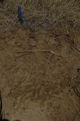
2023.2.2.12.7.10
·
Stuk
·
27 Aug. 2007
Part of Dr. Paul Sanborn fonds
2023.2.2.12.7.11
·
Stuk
·
27 Aug. 2007
Part of Dr. Paul Sanborn fonds
2023.2.2.12.7.25
·
Stuk
·
27 Aug. 2007
Part of Dr. Paul Sanborn fonds
2023.2.2.12.7.26
·
Stuk
·
27 Aug. 2007
Part of Dr. Paul Sanborn fonds
2023.2.2.12.7.35
·
Stuk
·
28 Aug. 2007
Part of Dr. Paul Sanborn fonds
2023.2.2.12.7.40
·
Stuk
·
28 Aug. 2007
Part of Dr. Paul Sanborn fonds
2023.2.2.12.7.42
·
Stuk
·
28 Aug. 2007
Part of Dr. Paul Sanborn fonds
2023.2.2.12.7.46
·
Stuk
·
29 Aug. 2007
Part of Dr. Paul Sanborn fonds
2023.2.2.12.7.53
·
Stuk
·
9 Aug. 2008
Part of Dr. Paul Sanborn fonds
2023.2.2.13.2
·
Bestanddeel
·
Jul. 2007
Part of Dr. Paul Sanborn fonds
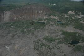
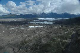
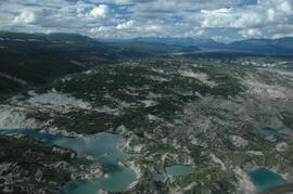
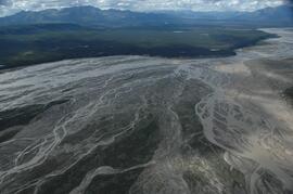
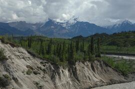
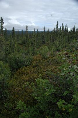
These images were obtained on the helicopter flights to and from the Klutlan Glacier study site. The outbound sequence (#5590-5706) starts from the base camp at the White River crossing on the Alaska Highway and heads south, to a point just upvalley of the debris-covered terminus (approx. 10-15 km from Alaska border), and turning back north to the landing spot on the Generc River floodplain close to the study site (see Fig. 1 in paper). On the return leg at the end of the day, the flight initially went upvalley to pick up another party (#5884-5926), before turning north and returning to base camp (#5929-5993).
2023.2.2.13.2.04
·
Stuk
·
8 Jul. 2007
Part of Dr. Paul Sanborn fonds
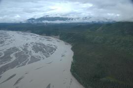
This image is part of the outbound sequence of aerial images obtained on the helicopter flight to the Klutlan Glacier study site. The sequence starts from the base camp at the White River crossing on the Alaska Highway and heads south, to a point just upvalley of the debris-covered terminus (approx. 10-15 km from Alaska border), and turning back north to the landing spot on the Generc River floodplain close to the study site (see Fig. 1 in paper).
2023.2.2.13.2.18
·
Stuk
·
8 Jul. 2007
Part of Dr. Paul Sanborn fonds
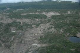
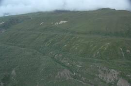
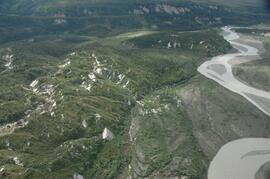
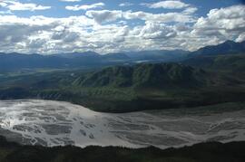
This image is part of the outbound sequence of aerial images obtained on the helicopter flight to the Klutlan Glacier study site. The sequence starts from the base camp at the White River crossing on the Alaska Highway and heads south, to a point just upvalley of the debris-covered terminus (approx. 10-15 km from Alaska border), and turning back north to the landing spot on the Generc River floodplain close to the study site (see Fig. 1 in paper).
2023.2.2.13.2.20
·
Stuk
·
8 Jul. 2007
Part of Dr. Paul Sanborn fonds
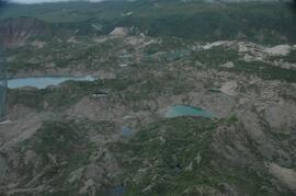
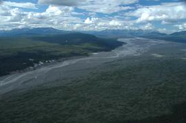
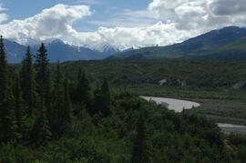
This image is part of the outbound sequence of aerial images obtained on the helicopter flight to the Klutlan Glacier study site. The sequence starts from the base camp at the White River crossing on the Alaska Highway and heads south, to a point just upvalley of the debris-covered terminus (approx. 10-15 km from Alaska border), and turning back north to the landing spot on the Generc River floodplain close to the study site (see Fig. 1 in paper).
2023.2.2.13.2.22
·
Stuk
·
8 Jul. 2007
Part of Dr. Paul Sanborn fonds
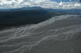
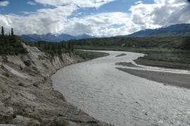
This image is part of the outbound sequence of aerial images obtained on the helicopter flight to the Klutlan Glacier study site. The sequence starts from the base camp at the White River crossing on the Alaska Highway and heads south, to a point just upvalley of the debris-covered terminus (approx. 10-15 km from Alaska border), and turning back north to the landing spot on the Generc River floodplain close to the study site (see Fig. 1 in paper).
2023.2.2.13.2.25
·
Stuk
·
8 Jul. 2007
Part of Dr. Paul Sanborn fonds
This image is part of the outbound sequence of aerial images obtained on the helicopter flight to the Klutlan Glacier study site. The sequence starts from the base camp at the White River crossing on the Alaska Highway and heads south, to a point just upvalley of the debris-covered terminus (approx. 10-15 km from Alaska border), and turning back north to the landing spot on the Generc River floodplain close to the study site (see Fig. 1 in paper).
2023.2.2.13.2.30
·
Stuk
·
8 Jul. 2007
Part of Dr. Paul Sanborn fonds
This image is part of the outbound sequence of aerial images obtained on the helicopter flight to the Klutlan Glacier study site. The sequence starts from the base camp at the White River crossing on the Alaska Highway and heads south, to a point just upvalley of the debris-covered terminus (approx. 10-15 km from Alaska border), and turning back north to the landing spot on the Generc River floodplain close to the study site (see Fig. 1 in paper).
2023.2.2.13.2.34
·
Stuk
·
8 Jul. 2007
Part of Dr. Paul Sanborn fonds
This image is part of the outbound sequence of aerial images obtained on the helicopter flight to the Klutlan Glacier study site. The sequence starts from the base camp at the White River crossing on the Alaska Highway and heads south, to a point just upvalley of the debris-covered terminus (approx. 10-15 km from Alaska border), and turning back north to the landing spot on the Generc River floodplain close to the study site (see Fig. 1 in paper).
2023.2.2.13.2.48
·
Stuk
·
9 Jul. 2007
Part of Dr. Paul Sanborn fonds
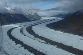
This image is part of the return trip sequence of aerial images obtained on the helicopter flight leaving the Klutlan Glacier study site. On the return leg at the end of the day, the flight initially went upvalley to pick up another party.
2023.2.2.13.2.51
·
Stuk
·
9 Jul. 2007
Part of Dr. Paul Sanborn fonds
This image is part of the return trip sequence of aerial images obtained on the helicopter flight leaving the Klutlan Glacier study site. On the return leg at the end of the day, the flight initially went upvalley to pick up another party.
2023.2.2.13.2.52
·
Stuk
·
9 Jul. 2007
Part of Dr. Paul Sanborn fonds
This image is part of the return trip sequence of aerial images obtained on the helicopter flight leaving the Klutlan Glacier study site. On the return leg at the end of the day, the flight initially went upvalley to pick up another party.
2023.2.2.13.2.53
·
Stuk
·
9 Jul. 2007
Part of Dr. Paul Sanborn fonds
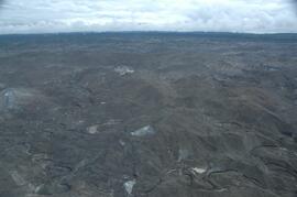
This image is part of the return trip sequence of aerial images obtained on the helicopter flight leaving the Klutlan Glacier study site. On the return leg at the end of the day, the flight initially went upvalley to pick up another party. This image was taken after the helicopter turned north to return to base camp.
2023.2.2.13.2.55
·
Stuk
·
9 Jul. 2007
Part of Dr. Paul Sanborn fonds
This image is part of the return trip sequence of aerial images obtained on the helicopter flight leaving the Klutlan Glacier study site. On the return leg at the end of the day, the flight initially went upvalley to pick up another party. This image was taken after the helicopter turned north to return to base camp.
2023.2.2.13.2.59
·
Stuk
·
9 Jul. 2007
Part of Dr. Paul Sanborn fonds
This image is part of the return trip sequence of aerial images obtained on the helicopter flight leaving the Klutlan Glacier study site. On the return leg at the end of the day, the flight initially went upvalley to pick up another party. This image was taken after the helicopter turned north to return to base camp.
2023.2.2.13.2.64
·
Stuk
·
9 Jul. 2007
Part of Dr. Paul Sanborn fonds
This image is part of the return trip sequence of aerial images obtained on the helicopter flight leaving the Klutlan Glacier study site. On the return leg at the end of the day, the flight initially went upvalley to pick up another party. This image was taken after the helicopter turned north to return to base camp.
2023.2.2.13.2.66
·
Stuk
·
9 Jul. 2007
Part of Dr. Paul Sanborn fonds
This image is part of the return trip sequence of aerial images obtained on the helicopter flight leaving the Klutlan Glacier study site. On the return leg at the end of the day, the flight initially went upvalley to pick up another party. This image was taken after the helicopter turned north to return to base camp.
2023.2.2.13.2.67
·
Stuk
·
9 Jul. 2007
Part of Dr. Paul Sanborn fonds
This image is part of the return trip sequence of aerial images obtained on the helicopter flight leaving the Klutlan Glacier study site. On the return leg at the end of the day, the flight initially went upvalley to pick up another party. This image was taken after the helicopter turned north to return to base camp.
2023.2.2.13.2.73
·
Stuk
·
9 Jul. 2007
Part of Dr. Paul Sanborn fonds
This image is part of the return trip sequence of aerial images obtained on the helicopter flight leaving the Klutlan Glacier study site. On the return leg at the end of the day, the flight initially went upvalley to pick up another party. This image was taken after the helicopter turned north to return to base camp.
2023.2.2.13.3.07
·
Stuk
·
8 Jul. 2007
Part of Dr. Paul Sanborn fonds
2023.2.2.13.3.12
·
Stuk
·
8 Jul. 2007
Part of Dr. Paul Sanborn fonds
2023.2.2.13.3.14
·
Stuk
·
8 Jul. 2007
Part of Dr. Paul Sanborn fonds
2023.2.2.13.3.17
·
Stuk
·
8 Jul. 2007
Part of Dr. Paul Sanborn fonds
2023.2.2.13.3.19
·
Stuk
·
8 Jul. 2007
Part of Dr. Paul Sanborn fonds
2023.2.2.13.3.26
·
Stuk
·
8 Jul. 2007
Part of Dr. Paul Sanborn fonds
2023.2.2.13.3.28
·
Stuk
·
8 Jul. 2007
Part of Dr. Paul Sanborn fonds
2023.2.2.13.3.36
·
Stuk
·
8 Jul. 2007
Part of Dr. Paul Sanborn fonds
2023.2.2.13.3.38
·
Stuk
·
9 Jul. 2007
Part of Dr. Paul Sanborn fonds
2023.2.2.13.3.42
·
Stuk
·
9 Jul. 2007
Part of Dr. Paul Sanborn fonds
2023.2.2.13.3.52
·
Stuk
·
9 Jul. 2007
Part of Dr. Paul Sanborn fonds
2023.7.1
·
Reeks
·
1991-2000
Part of Grant Hazelwood fonds
Series consists of records created and collected by wildlife biologist Grant Hazelwood in relation to his Tailed Frog (Ascaphus truei) research.
2023.7.1.05
·
Bestanddeel
·
Oct. 1996
Part of Grant Hazelwood fonds
File consists of a photocopy of a 1996 report by Pacific Cascade Consultants Ltd. entitled "Tailed Frog Habitat and Population Monitoring - Year 3 - 1996" prepared for BC Ministry of Forests Kalum District.
2023.7.1.08
·
Bestanddeel
·
8 Dec. 1999
Part of Grant Hazelwood fonds
File consists of the original version a report prepared by Grant Hazelwood for the BC Conservation Officer Service entitled "Documentation of 'Noname Creek' [Station 13 + 500] on Fiddler Mainline forest road as suitable habitat for supporting Tailed Frogs [Ascaphus truei], a Blue Listed species in British Columbia".
2023.7.2
·
Reeks
·
1979-1986
Part of Grant Hazelwood fonds
Series consists of records created and collected by Grant Hazelwood for the BC Ministry of Environment's "Upper Nass Assessment Project", a project that included the biophysical mapping of the Northwest-Klappan Road Access Area. Grant Hazelwood (Alpenglow Resources) was hired as the wildlife biologist for to undertake project work.
2023.7.2.02
·
Bestanddeel
·
1984-1986
Part of Grant Hazelwood fonds
File consists of Grant Hazelwood's notes and collected correspondence created in conjunction with the BC Ministry of Environment's "Upper Nass Assessment Project", a project that included the biophysical mapping of the Northwest-Klappan Road Access Area. Includes a summary document entitled "Klappan Access Road Project - Wildlife Component", as well as Hazelwood's handwritten species inventory notes.
2023.7.2.05
·
Bestanddeel
·
Oct. 1984
Part of Grant Hazelwood fonds
File consists of an original "Mount Klappan Anthracite Project" document by Gulf Canada Resources Ltd. Includes accompanying map entitled "Gulf Canada Resources Inc.: Northwest British Columbia" that shows proposed coal mine sites in the Mount Klappan area, near Spatsizi Wilderness Park and Tatlatui Provincial Park.
2023.7.2.06
·
Bestanddeel
·
Apr. 1985
Part of Grant Hazelwood fonds
File consists of an original "Mount Klappan Access Road Study" proposal for consulting services to the BC Ministry of Industry and Small Business Development by Phillips Barratt Kaiser Engineering Ltd. in association with Associated Engineering (B.C.) Ltd.
2023.7.2.11
·
Bestanddeel
·
Mar. 1979
Part of Grant Hazelwood fonds
File consists of an original reproduction of a map entitled "Spatsizi Provincial Park Key Map" by BC Parks.