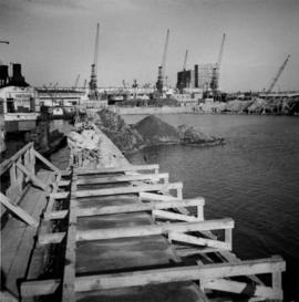
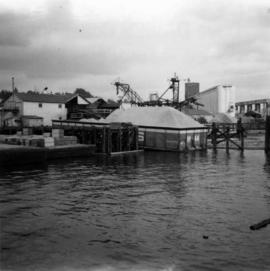
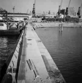
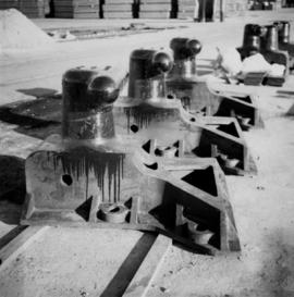
Photograph depicts bollards for erection in new sea wall, to make outer face of the deep sea wharf being constructed at Dunlevey St. in Vancouver, B.C.
Photograph depicts the north shore of False Creek, looking west after a snowfall. Photo taken from the swing span of Cambie Bridge in Vancouver, B.C.
Photograph depicts a scow with chips landing on the north shore of Vancouver harbour. There are Saskatchewan wheat elevators in the background.
Photograph depicts the Shaughnessy Golf Course abandoned but still played upon. There is an excavator working on drainage for a subdivision in the middle distance. The view is looking southwest from the corner of the course at Oak and 33rd Ave. in Vancouver, BC
Photograph depicts a truck at the Teepoortens Truck and Equipment Rentals Ltd., located at 950 West 6th Ave. in Vancouver, BC
Photograph depicts a West Coast Railway Association 2-8-2 tank locomotive and tender at a C.N. station in Vancouver, B.C.
Photograph depicts the business car "British Columbia" (ex. C.P.R.) at the C.N. station in Vancouver. It is tailing the special to Hope, on its first run since acquisition by the West Coast Railway Association.
Photograph depicts the C.P.R. terminal in Vancouver. A C.P.R. switcher is collecting cars from the "Princess of Vancouver" at about 7 p.m.
Photograph depicts the C.P.R. yards on Cambie St. in Vancouver, B.C. The view is looking west with False Creek on the left (out of the picture), after a snowfall.
Photograph depicts a C.P.R. wrecking crane at the Vancouver station.
Photograph depicts a coach stock in the C.P.R. False Creek yards in Vancouver, B.C.
Photograph depicts a tower controlling the C.P.R. grade crossing at Alexander St. in Vancouver, B.C.
Photograph depicts the north end of the False Creek trestle, looking east towards the C.P.R. yards in Vancouver.
Photograph depicts the B.C. Electric Railway crossing 3rd Ave. with the first intersection at the immediate left. Note the abandoned double trackage at left. The view is looking north.
Photograph depicts the former B.C. Electric Railway track crossing Sea Island Way near Bridgeport, Lulu Island, and looking north to the Oak St. road bridge. The track was lifted in 1965 when the new Steveston route went into service.
Photograph depicts a B.C. Electric Railway trolley electric locomotive #960, in freight yard below the Georgia Viaduct in Vancouver.
Photograph depicts special equipment opposite a car barn of the B.C. Electric Railway, at New Westminster.
Photograph depicts the Canadian National Railway (CN) train crossing Powell St. and the C.P.R. tracks to get to North Vancouver.
Photograph depicts a sand car at the Great Northern Railway depot in Vancouver, beside the Canadian National Railway (CN) depot.
Handwritten annotations on verso read: “The Northland mess - Basford + Long - sell out to Bennett”.
Photograph depicts Iona Campagnolo at a banquet and demonstration on the 14th anniversary of the Vancouver Tai-Chi Chuan Association. Raymond Chung, Master of the Tai-Chi Chuan Association, is cutting a large cake.
Photograph depicts a modern M. of W. rubbish skip at a CN yard in North Vancouver.
Photograph depicts a CNR lifting bridge in Vancouver.
File consists of Runka's 1961 UBC Totem yearbook.
This municipal map of the City of Vancouver from 1987 shows street names and street widening information.
File contains photographs pertaining to the transportation of asbestos fibre.
- These include portraits of Clinton trailer trucks, trucks from the Cassiar Transport Division at Mile 860 on the Alaskan Highway, the assembly of large freight trucks, an unidentified bridge, and ships and buildings at the Cassiar Shipping Facilities at Pier 94 on the Asbestos Warf in North Vancouver, B.C.
- Twenty-three photographs dated 1982 depict asbestos fiber bales on pallets and inside shipping containers, with accompanying annotations commenting on the quality of the packing. Several images show fibre bales broken during shipment. An accompanying note reads: "SMD - please ensure this cannot reoccur.", and a photo caption reads: "pierced bags are resulting as an environmental problem as fibre is beginning to build up in certain containers." One of the photographs depicting the Cassiar Transport Division was used for promotional posters with the following commentary: "The Cassiar Transport Division operates out of Whitehorse, Yukon Territory and is responsible for delivering the asbestos to the White Pass and Yukon Route terminal in Whitehorse. Fuel oil and supplies are backhauled to the mines. By the end of 1967, the fleet will consist of 65 tractor-trailer units, each of which will carry 23 tons of asbestos. The distance from Whitehorse to Cassiar is 357 miles and Clinton is 403 miles. During the past year, the Division's trucks traveled 2,213,534 miles and handled 75,100 tons, and the mileage to 3.5 million miles. This is a year-round operation and convoys arrive at the mine daily in spite of the long difficult haul. The Division currently employs 43 drivers and 35 mechanics and operates its own maintenance and rebuild facilities in Whitehorse. Over the years these men have established and enviable record of safety, cost and performance."
- Additional photographs that have been integrated depict the Asbestos wharf and its condition, 31 slides of wharf, maps of shipping routes, storage, forklifts, shipping trucks, and packaged asbestos.
- Also included in this file are two copies of a "Photo Survey - Cassiar Ton Units - "Amstelveld & Trojoland" on arrival to Brisbane & Sidney - August 1967." This collection of photographs is a part of an assessment of the efficiency of shipping and transport to Australia from Cassiar. Pictures include: loading, forklifts, storage, ripped bags, broken straps, wharfs, trucks, slings. There are accompanied annotations with each of the photos explaining the safety hazards or inefficiency of the situation. This report was found inside a box linked to James Hardie Industries Ltd. This company is not mentioned in the photograph annotations, but could be related to the report since James Hardie Industries Ltd. was a key player in asbestos mining and manufacturing in Australia.
- Collection of photos of roadside spill of Asbestos, depicting a man with shovel cleaning up on 5 June 1985
- Photos from Eternit Societe Anonyme (a European company that Cassiar shipped to) of packaged Asbestos in storage in 1967
- Collection of photos of James Hardie Coy. Pty. Ltd. shipment of asbestos that was not stored or transported effectively. Many photos depict broken bags as a result of inadequate storage and forklift punctures.
- Collection of photos of Cassiar/Stewart Road Proposal. Photos depict tests of the various stages of shipping and transportation process including forklift tests, Marineo Sling tests, stacking tests, durability tests, container loading tests, problems with current units etc. Also included is a marketing drawing if proposed shipping plan - drawn by "Stewart 1977."
- Photos of shipping process of Turners Asbestos Fibres Lmt. Photos depict lowering asbestos pallets onto barge with swing, and storage on barge.
- Collection of photos of a shipment of asbestos, but the bags of fibre are not identified as a Cassiar shipment therefore the location is unknown.
Typed on verso of ticket: "CANADIAN NATIONAL RAILWAYS WESTERN REGION" "EMPLOYES TRIP PASS - FIRST CLASS" "SUBJECT TO CONDITIONS ON BACK" "PASS (1) Miss V. B. Taylor, ACCOUNT Stenographer -- C.N.R. TO Vancouver, B.C. FROM Prince Rupert, B.C. via Jasper, Alta." "DATE ISSUED} June 14th/27. EXPIRES END OF} July. 1927" "ADDRESS Prince Rupert. REQD BY V.B.T." "HONORED ON TRAIN NO. [6]". Verso has been signed by the conductor (illegible) and dated "Jun 18".
Typed on recto of ticket: "PASS ONE WAY ONLY TW IN ACCORDANCE WITH ACCOMPANYING PASS, BUT IN OPPOSITE DIRECTION" "VOID IF DETACHED" "143518". Stamped annotation on recto: "[ISSUED BY] W. H. TOBEY". Handwritten annotation on recto: "OFF SNOWSHOED NO 5 JULY 13 [WM?]". Ticket has been punched with four different shapes.
The pair walks on sidewalk, wearing hats and long coats, Glassey on right. Crowd of walking people and tall buildings in background. Photograph taken by street photographer. Stamped annotation on recto of photograph: "SOUVENIR SNAPS 401 W. HASTINGS ST. VANCOUVER, B.C. EXTRA COPIES BY NUMBER."
Photograph depicts man and woman standing to left of dog and Bert Glassey on front steps to unknown building. Handwritten annotation on recto of photograph: "Hullat took over Agency after Uncle Bert."
Photograph taken in a hall with large glass windows at the University of British Columbia. Six indoor totem poles visible in background.
Handwritten notation included with photograph reads: “June 1982, First National Networking Conference, Compliments of Katherine Roth, Windsor, Ontario”.
Handwritten annotations on verso read: “In the great hall of the B.C. Museum of Anthropology, in front of Ninstints Totem wearing cape of Sahn-nag-x-wha (One who sits high) gift of Chief Skidegate ‘Dempsey’ Collinson - Q.C.I. made by his wife Irene for ‘naming feast’ Autumn - 1977. June 5, 1982, Address to the First National Womans Network. Age - almost 50.” And “Alive Again 82”.
Beverley A. Busson promoted from Deputy Commissioner for British Columbia and the Yukon, and commander of British Columbia to Commissioner. Handwritten notation on RCMP Commanding Officer letterhead included with photograph reads: “RCMP Change of Command, Bev Busson to Interim Com Cda, Gary Bass to Dep Com, E + M, Div”.
Handwritten annotation on verso reads: “Gag photo with my special assistant Lucie Lambert, August 1977, Vancouver.”
Photograph depicts a garden with large shrubs and tall trees. Handwritten annotation below photograph reads, "Views of Stanley Park"
Images within album consist primarily of fishery industry, river & landscapes, salmon cannery images (housing, people, workers, boats) on the Nass River and North Pacific Coast, ca.1924-1926. Each photograph is accompanied by a handwritten description glued below or beside the image.
Map depicts the proposed electoral districts of British Columbia, including: Burnaby, Capilano, Cariboo-Chilcotin, Comox-Powell River, Cowichan-Malahat-The Islands, Esquimalt-Saanich, Fort Nelson-Peace River, Fraser Valley East, Fraser Valley West, Kamloops-Shuswap, Kootenay East, Kootenay West, Mission-Port Moody, Nanaimo-Alberni, New Westminster-Coquitlam, North Vancouver-Burnaby, Okanagan North, Okanagan-Similkameen, Prince George-Bulkley Valley, Richmond-South Delta, Skeena, Surrey-White Rock-North Delta, Vancouver Centre, Vancouver East, Vancouver Kingsway, Vancouver Quadra, Vancouver South, and Victoria.
Map depicts annotations of the freight-way routes throughout British Columbia. These routes include: the Garnet Enterprise Truck Haul from Vancouver to Terrace, the Canadian Freightways from Vancouver to Edmonton to Alaska; the Lindsay Transfer from Terrace to Dease Lake and Telegraph Creek; and the Northland Navigation roll-on and roll-off service.
Photograph depicts a courthouse in Vancouver, B.C. Photo shows the ripped up forecourt.
Photograph depicts gulls at Lost Lagoon in Vancouver, B.C.
Photograph depicts homes on 1000 Beach Ave., looking northeast.
Photograph depicts the ongoing wrecking of house #1053 on Beach Ave.
Photograph depicts the homes on 1000 Beach Ave. in Vancouver, B.C.
Photograph depicts Granite Falls near the Wigwam Inn, Indian Arm, Vancouver, B.C.
Photograph depicts the entrance to False Creek in Vancouver, B.C. The wooden navigation marker has since been removed. The photo is taken from 1053 Beach Ave.
Photograph depicts the Vancouver Shipyards Ltd. on 555 Denman St. in Vancouver, B.C., looking south from Coal Harbour waters.
Photograph depicts the west end of Coal Harbour looking south to West Georgia St. and Chilco-Gilford block beyond. The old pilings exposed at low tide.
Photograph depicts the site of a new deep water ship wharf with Centennial Pier in the background, looking east. Left of the wall is the sea and the right side will be dirt filled.
Photograph depicts the site of a new deep water ship wharf. The left of the wall is sea and the right will be filled in with dirt. The view is looking east and shows the Centennial Pier in the background.