2013.15.16
·
Item
·
Oct. 1995
Part of Cariboo-Chilcotin Regional Planning Collection
269 results with digital objects
Show results with digital objects
2013.15.12
·
Item
·
1994
Part of Cariboo-Chilcotin Regional Planning Collection
2020.4.2.3.048
·
File
·
Sept. 1979
Part of G. Gary Runka fonds
File consists of two original unbound volumes of the draft report "Carcross Valley - Marsh/Tagish Lakes - Atlin Road Land Management Planning Project" released September 1979 by the Department of Indian Affairs and Northern Development and the Government of the Yukon. Volume 1 consists of "Review Framework and Resource Data" and Volume 2 consists of "Resource Data Maps".
2012.13.2.16.38
·
File
·
2001
Part of J. Kent Sedgwick fonds
File consists of notes relating to Hixon Elementary School (formerly Canyon Creek Elementary School). Also includes photographs depicting the old Canyon Creek School site (2001).
1996.8.4.60
·
File
·
2002
Part of Chander Suri fonds
File consists of correspondence regarding the Forest Health Development Plan and maps from Canfor Forest Products Ltd. (Canfor).
2012.13.2.20.15
·
File
·
2005-2010
Part of J. Kent Sedgwick fonds
File consists of notes and reproductions relating to the Canadian Pacific Railway, colonization and immigration, and the 4th Duke of Sutherland.
1996.8.3.37
·
File
·
1974
Part of Chander Suri fonds
File consists of meeting minutes from the Annual General Meeting of the Canadian Institute of Planners. Includes one package of meeting minutes and a supplementary package of financial statements.
2020.4.2.3.107
·
File
·
1997
Part of G. Gary Runka fonds
File is a Greenpeace presentation folder with a package of reports and ephemera about the Canadian Great Bear Rainforest.
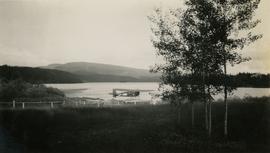
2020.05.26
·
Item
·
[Sept. or Oct. 1936]
Part of Gordon Wyness Album
Photograph depicts the Canadian Airways Ltd Fairchild 71C CF-AWV float airplane at the shore of Burns Lake. The float plane was serving as a photography plane.
2020.4.2.3.065
·
Item
·
1986
Part of G. Gary Runka fonds
Item is an original copy of "Canada's Environment: An Overview" by Environment Canada.
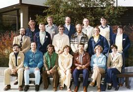
2020.4.8.2.008
·
Item
·
[197-?]
Part of G. Gary Runka fonds
Photograph is a group portrait of the attendees at a Canada National Land Use meeting. Back row, left to right: Gary Runka, Bruce Chambers, Frank Heaps, Vern Spencer, Peter Whiting. Middle row, left to right: Bob Scace, Lee Munn, Bill Bourgeois, Jim Murphy, Gerry Acott, Dave Rochefort. Front row, left to right: Mike Simmons, Les Cooke, John Hetherington, Betty McGregor, Daniel Paquette, Peggy Thompson, Patsy Murphy.
2020.4.2.3.057
·
Item
·
[1982 or 1983]
Part of G. Gary Runka fonds
Item is a pamphlet entitled "Canada Land Use Monitoring Program (CLUMP)".
![Canada Land Inventory National Soil Survey [?] group portrait](/uploads/r/northern-bc-archives-special-collections-1/4/b/6/4b63620d93fd801efb07b2dd93008b6f63d5d340f359bdabe11106ae8bb04dbe/2020_4_8_2_005_142.jpg)
2020.4.8.2.005
·
Item
Part of G. Gary Runka fonds
Photograph is a group portrait of the Canada Land Inventory team , possibly related to the National Soil Survey. Individuals identified: Norm Sprout (back row, 5th from left); Les Lavkulich (back row, 6th from left); Dr. Charlie Rowles (back row, 6th from right); Pat Duffy (3rd row back, 6th from right); Gary Runka (3rd row back, 5th from right).
1996.8.3.23
·
File
·
1970
Part of Chander Suri fonds
File consists of a report about the Canada Land Inventory Program that examines disparities between urban and rural communities and offers solutions. Also includes a document entitled "The Place of the Canada Land Inventory Program in Resource Management: The Regional District of Fraser-Fort George".
2003.13.1.2.098
·
Item
·
[19-?]
Part of Parker Bonney Photograph Collection
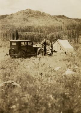
2020.05.29
·
Item
·
[Sept. or Oct. 1936]
Part of Gordon Wyness Album
Photograph depicts (from left to right) Gordon Wyness and Jack Lee at their campsite at Sheraton. This location may reference the small community east of Burns Lake on the Canadian National Railway line. Wyness notes that "Sherton" [Sheraton?] Mountain is visible in the background of the photograph; the current name of that geographical feature could not be determined. The survey crew's car and tent are also visible in the image.
2020.4.2.3.067
·
Item
·
1986
Part of G. Gary Runka fonds
Item is a copy of "Campbell River Area Park Plan" by the Regional District of Comox Strathcona.
2012.13.2.16.39
·
File
·
[between 2001 and 2005]
Part of J. Kent Sedgwick fonds
File consists of notes relating to Camp Creek Elementary School.
2000.23.1.045.01
·
Item
·
June 1986
Part of Audrey Smedley L'Heureux fonds
The publication is a commemorative newsletter for the 180th Birthday celebration of Fort St. James. The publication was created by the Fort St. James Chamber of Commerce as a supplement to the Caledonia Courier. The publication also depicts the early pioneers of Fort St. James.
2012.13.2.16.40
·
File
·
[between 2001 and 2005]
Part of J. Kent Sedgwick fonds
File consists of notes relating to the Cale Creek Elementary School.
1996.8.4.01
·
File
·
1979
Part of Chander Suri fonds
File consists of by-law 385 for the Regional District of Fraser-Fort George establishing a settlement plan for Area A and Summit Lake. By-Law 374 is also included.
2020.4.3.29
·
File
·
1970-2013
Part of G. Gary Runka fonds
File consists of G. Gary Runka's business card collection, which includes many unique examples of business cards from BC, Canada, and beyond. Includes cards for personal contacts and businesses as well as business contacts.
1996.8.4.79
·
File
·
1990
Part of Chander Suri fonds
File consists of a physical development plan prepared by Stanley Associates Engineering Ltd. for the Burns Lake Band, currently known as Ts'il Kaz Koh.
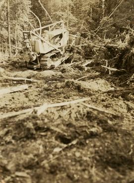
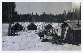
2020.05.30
·
Item
·
[Sept. or Oct. 1936]
Part of Gordon Wyness Album
Photograph depicts a bulldozer clearing land for road making north of Stuart Lake.
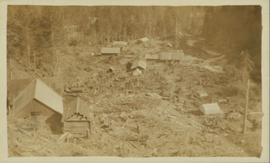
2011.13.70
·
Item
·
ca.1910-ca.1930
Part of Parker photograph collection
Photograph is a printed postcard depicting scattered small buildings and a tent. Trees have been removed from the area around the buildings and many stumps remain.
2012.13.2.16.41
·
File
·
[between 2001 and 2005]
Part of J. Kent Sedgwick fonds
File consists of notes relating to Buckhorn Elementary School. Also includes photographs depicting the old Buckhorn School building and the Prince George Snowmobile club building from the exterior (between 2001 and 2005).
2003.11.1.39
·
File
·
1999-2000
Part of Island Cache Recovery Project Collection
File consists of an oral history given by Bruno Randt, which was gathered as part of Dr. Mike Evan's Island Cache Recovery Project. Includes consent forms, transcripts, and the recorded oral history on the original media.
1996.8.4.69
·
File
·
1987
Part of Chander Suri fonds
File consists of a planning study of Broman Lake prepared by Tera Environmental Consultants Ltd. for the Broman Indian Band, currently known as Ts'il Kaz Koh.
1996.8.4.67
·
File
·
1995-1996
Part of Chander Suri fonds
File consists of cost estimates, forest cover maps, a blank population and social survey, and some handwritten notes for the physical development plan of the Broman Lake Band, currently known as Ts'il Kaz Koh.
1996.8.4.68
·
File
·
[199-?]
Part of Chander Suri fonds
File consists of four aerial photographs of the Broman Lake area.
2020.4.2.3.081
·
Item
·
1991
Part of G. Gary Runka fonds
Item is a photocopied version of "British Columbia Snowmobile Area Inventory Study" prepared by BC Snowmobile Federation for the BC Ministry of Tourism.
2020.4.2.3.030
·
Item
·
Sept. 1969
Part of G. Gary Runka fonds
Item is an original typescript of "British Columbia Recreation Sector Analysis East Kootenay Intersector Evaluation" by the Canada Land Inventory (ARDA) Recreation Sector, led by W.C. Yeomans.
2020.4.3.17
·
File
·
2008-2012
Part of G. Gary Runka fonds
File consists of selected correspondence, mailings, newsletters, pamphlets and workshop information from the British Columbia Institute of Agrologists (BCIA). Gary Runka was a long-time BCIA member. Includes issues of the British Columbia Institute of Agrologists (BCIA) Newsletter, the BCIA Special Report for the 65th Annual General Meeting, workshop materials for the BCIA 2012 ethics workshop, and the BCIA Committee on Principles of Stewardship Report to Council (29 March 2010).
2020.4.2.3.085
·
Item
·
1992
Part of G. Gary Runka fonds
Item is an original report by the BC Min. of Agriculture, Fisheries and Food entitled "British Columbia Grains and Seeds Strategy: An Industry Development Plan".
2020.4.2.3.069
·
Item
·
1988
Part of G. Gary Runka fonds
Item is a photocopied version of "British Columbia Cross Country Ski Area Study" prepared by Nordic Group International under Canada-British Columbia Tourism Industry Development Subsidiary Agreement.
2001.1.054
·
Item
·
Feb. 1912
Part of NBCA Document and Ephemera Collection
Item is issue Vol. 2 No. 4 from February 1912 of the "British Columbia Bulletin of Information", a promotional mouthpiece of the Natural Resources Security Company. The publication is self-described as "About the vast natural resources and commercial, agricultural and mining progress, together with a synopsis of the laws regulating public lands, timber, coal and other minerals, and current record of development in British Columbia, Alberta and Saskatchewan for the business man, the farmer and the investor". The headline of this issue is "B.C. Government Guarantees Bonds of Railway to connect Fort George with Vancouver". The Natural Resources Security Company was a development company that sold a significant amount of land in Fort George.
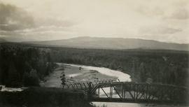
2020.05.19
·
Item
·
[Sept. or Oct. 1936]
Part of Gordon Wyness Album
Photograph depicts two bridges crossing the Telkwa River. Wyness notes (on photograph verso) that this is where their survey crew traversed the river; he also noted erosion in the area.
2020.4.6.021.05
·
Item
·
Sept. 1979
Part of G. Gary Runka fonds
2003.11.1.18
·
File
·
1999-2000
Part of Island Cache Recovery Project Collection
File consists of an oral history given by Bradley Johnson, which was gathered as part of Dr. Mike Evan's Island Cache Recovery Project. Includes consent forms, transcripts, and the recorded oral history on the original media.
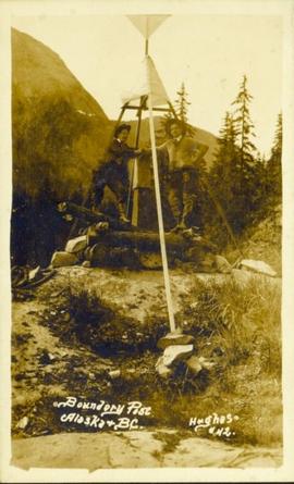
2011.13.26
·
Item
·
ca.1910-ca.1930
Part of Parker photograph collection
Photograph of two men posing next to a four-legged post erected in the wilderness. Printed annotation on recto reads: "Boundery[sic] Post Alaska & BC. Hughes #42."
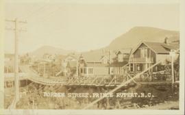
2011.3.3.52
·
Item
·
[ca.1909-1930]
Part of North Coast & Central BC Postcard Collection
Wide angle view of Borden Street in Prince Rupert. Many residential buildings line the wooden road with railing. Printed annotation on recto reads: "Borden Street. Prince Rupert B.C."
2002.12.10
·
Item
·
c.1970 - c.1989
Part of Bob Harkins fonds
Item consists of interview with Walter Gill who discusses his career in the BC Provincial Police in Central Interior. Also talks about trapping in region.
Harkins, Bob
2023.5.1.05
·
Item
·
Sept. 1976
Part of UNBC School of Planning and Sustainability fonds
Item is a hand drawn and coloured map by the City of Prince George Planning Department depicting the Blackburn neighbourhood development area's proposed sector plan in 1976.
2003.11.1.33
·
File
·
1999-2000
Part of Island Cache Recovery Project Collection
File consists of an oral history given by Bjorn Norheim, which was gathered as part of Dr. Mike Evan's Island Cache Recovery Project. Includes consent forms, transcripts, and the recorded oral history on the original media.
2020.4.2.2.09
·
Item
·
[1972 or 1973]
Part of G. Gary Runka fonds
Item is a reproduced conference paper for the 4th North American Forest Soils Conference entitled "Bio-Physical Land Classification in Canada" by authors M. Jurdant (Canadian Forestry Service), D.S. Lacate (UBC), S.C. Zoltai (Northern Forest Research Center), G.G. Runka (B.C. Department of Agriculture), and R. Wells (Newfoundland Research Centre).
2020.4.6.518.06
·
Item
·
July 1999
Part of G. Gary Runka fonds
Audio cassette is Tape 6 of a recording of a Biologists Workshop for the Biodiversity Ranches project. Recording is from 2:00-4:30 pm on July 21, 1999.
2020.4.6.518.05
·
Item
·
July 1999
Part of G. Gary Runka fonds
Audio cassette is Tape 5 of a recording of a Biologists Workshop for the Biodiversity Ranches project. Recording is from 11:00 am - 2:00 pm on July 21, 1999.
2020.4.6.518.04
·
Item
·
July 1999
Part of G. Gary Runka fonds
Audio cassette is Tape 4 of a recording of a Biologists Workshop for the Biodiversity Ranches project. Recording is from 13:30-4:30 pm on July 20, 1999 on Side A and 9:30-11:0-00 am on July 21 on Side B.
2020.4.6.518.03
·
Item
·
July 1999
Part of G. Gary Runka fonds
Audio cassette is Tape 3 of a recording of a Biologists Workshop for the Biodiversity Ranches project. Recording is from 1:00-3:00 pm on July 20, 1999.
2020.4.6.518.02
·
Item
·
July 1999
Part of G. Gary Runka fonds
Audio cassette is Tape 2 of a recording of a Biologists Workshop for the Biodiversity Ranches project. Recording is from 11:00 am-12:00 pm on July 20, 1999 on Side A and 8:30-9:30 am on July 21 on Side B.