File consists of E.P. 657.06 Test Site Report, region 9 Nechako site 2 Fraser Lake, Block 83 & 84.
File consists of E.P. 657.06 Test Site Report, region 8 Willow site 3 Camp 4 Block 75 & 76.
File consists of E.P. 657.06 Test Site Report, region 10 Mackenzie site 1 Blackwater, block 91 & 92.
File consists of E.P. 657.06 Test Site Report, region 10 Mackenzie site 3 Dog Creek Block 95 & 96.
File consists of E.P. 657.06 Test Site Report, region 10 Mackenzie site 5 Salmon Lake, Block 99 & 100.
File consists of notes and documentation for experiment 657.06.
File consists of photographs of trees and forests, some photographs include Harry Coates.
File consists of an index indicating the hosts, where delegates are staying, and municipalities attending the Union of British Columbia Municipalities convention.
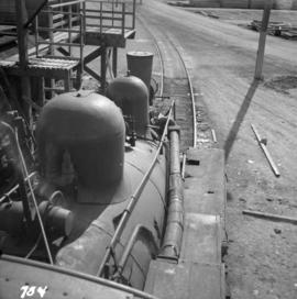
Photograph depicts 6-truck Shay locomotive #114 belonging to the Railway Appliance Company at the Vancouver Wharves Ltd. in North Vancouver. It is used each week.
Item is a notebook entitled "70 Anecdotes for Rainbow Trout".
Gridded aerial plan of agricultural lands from Fraser Lake to Prince George.
The photograph depicts a two-story white house at 7295 Cummings Road outside of Prince George. Annotation on reverse side of photograph states, "7295 Cummings Rd, relocated 1976."
File contains correspondence regarding lack of funding for research projects between the Science Council of British Columbia and Mike Jull, Prince George Forest Region.
Sun beginning to set on Takla Lake, Northern British Columbia
These remote-sensing aerial photographs were taken by Lockwood Survey Corporation Ltd. under contract for the B.C. Forest Service. Some photographs are annotated to show logging activity; clearcuts, slash piles, log booms, and tree debris on the water are also visible in some of the images. No detailed location information or index accompanies the photographs. These historically important aerial photographs depict Williston Lake soon after its creation in 1968 with the building of the W.A.C. Bennett Dam on the Peace River. Also depicted are the rivers and tributaries that empty into the Williston Reservoir, such as the Finlay River, the Ospika River, and the Omineca River.
The identification coding on these photographs can be interpreted as follows:
- The largest number on the leftmost side is the frame number for the individual photograph.
- The following code to the right in the format B) 69-53 is currently unknown, but may refer to an internal project number for the Lockwood Survey Corporation.
- The 6" may refer to the camera's focal length in inches.
- Next is "17,150 ASL" which is 17,150 feet Above Sea Level.
- Following is "152.52" which refers to the camera's focal length in millimeters, which equals 6 inches.
- The "W1307" may refer to the reel, but that is unconfirmed.
- "8 SEP 69" is the date the photos were taken.
Lateral detail of <i>Clerodendrum thomsoniae</i> in flower
File consists of documentation on E.P. 819.06.03.01 Holmes River Half-Sib Progeny Trial.
File consists of documentation on E.P. 819.08.03.01 Black Birch Creek Half-Sib Progeny Trial.
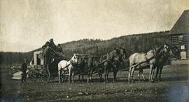
Photograph depicts a stage coach harnessed with six horses, a fence and a log building in the background.
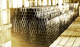
Photograph depicts a large stack of cans. Handwritten annotation below photograph reads, "830 cases of tall cans".
The item is a photograph depicting the side view of a white house located at 886 Vancouver Street, Prince George.
The item is a photograph depicting the garage located at the back of 886 Vancouver Street, Prince George.
The item is a photograph depicting the back of a white house and garage located at the back of 886 Vancouver Street, Prince George.
The item is a photograph depicting the front view of a white house located at 886 Vancouver Street, Prince George.
Consists of the 9 January 1990 edition of the Prince George Citizen. Front page headline reads as follows : "Here's Our University Plan!" Subheading reads as follows : "Facilities Would Cost $169 Million"
These remote-sensing aerial photographs were taken by Lockwood Survey Corporation Ltd. under contract for the B.C. Forest Service. Some photographs are annotated to show logging activity; clearcuts, slash piles, log booms, and tree debris on the water are also visible in some of the images. No detailed location information or index accompanies the photographs. These historically important aerial photographs depict Williston Lake soon after its creation in 1968 with the building of the W.A.C. Bennett Dam on the Peace River. Also depicted are the rivers and tributaries that empty into the Williston Reservoir, such as the Finlay River, the Ospika River, and the Omineca River.
The identification coding on these photographs can be interpreted as follows:
- The largest number on the leftmost side is the frame number for the individual photograph.
- The following code to the right in the format "B) 69-53" is currently unknown, but may refer to an internal project number for the Lockwood Survey Corporation.
- The 6" may refer to the camera's focal length in inches.
- Next is "17,150 ASL" which is 17,150 feet Above Sea Level.
- Following is "152.52" which refers to the camera's focal length in millimeters, which equals 6 inches.
- The "W1308" may refer to the reel, but that is unconfirmed.
- "9 SEP 69" is the date the photos were taken.
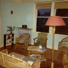
Photograph depicts the inside of the suite at 925 Cadero St. in the west end of Vancouver, B.C.
The item is a photograph depicting the side view of a green coloured house at 983 Vancouver Street in Prince George.
The item is a photograph depicting the side view of a green coloured house at 983 Vancouver Street in Prince George.
Frontal detail of <i>Agoseris</i> in fruit, Northwest Territories [?]
Frontal detail of <i>Amaryllis</i>
Habitat of <i>Andromeda polifolia</i> in flower, Nunavut
[Habit of] <i>Androsace</i> [in flower]
Habit of <i>Androsace</i> in white flower with yellow centres
Frontal detail of <i>Anemone narcissiflora<i> in flower
Frontal detail of <i>Anemone parviflora</i> in flower
Yukon Territory
Frontal detail of <i>Antennaria</i> [?] in flower, Alaska
Detail of <i>Arctostaphalus rubra</i> ("red bearberry") in fruit, Alaska
Frontal detail of <i>Arnica</i> in flower, Nunavut
Frontal detail of <i>Arnica</i> in yellow flower, [Lynne Valley?]
Habit of <i>Aster</i> in pink flower
Habit of <i>Astragalus</i> and <i>Stellaria</i> in flower, Nunavut
Detail of <i>Bartsia alpina</i> in flower, Churchill, Manitoba
Habit of <i>Bartsia alpina</i> in flower, Churchill, Manitoba
Lateral detail of <i>Bistorta</i> in flower, Alaska
