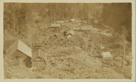
Photo of entire ship building plant, including several vessels in the foreground. Hills are visible in the background. Annotation on recto reads: "Prince Rupert Ship Repair and Ship Building Plant. Prince Rupert BC. Frank E Kirby, William T Donnelly, Engineers. 17 Battery Place. NYC."
View of the road descending to the waterfront. Buildings and forested area are visible on either side of street. Mountains clear in the background.
Photograph of post office and neighbouring building. Both buildings are composed of wood and tent materials. Annotation on recto reads: "Post Office & Customs House, Prince Rupert, BC."
Photograph depicts a ranch home and barn along the road from Lillooet to Clinton. The location is believed to be a homestead 2 miles south of Pavilion Station. Two cars are parked beside the property, with a number of men nearby.
Photograph depicts the Cariboo Road near Clinton, B.C.
Photograph depicts one unidentified man surveying a landscape from a snowy mountain peak with other mountain ranges in the background.
Photograph depicts the townsite of Hudson's Hope featuring a number of small wooden buildings clustered in a field. The Hudson's Bay post is building visible on far left.
Street view of 5th St. in Prince Rupert BC. The dirt road is flanked by two partially demolished rock faces. Printed annotation on recto reads: "5th St Prince Rupert, B.C."
Photograph of a large explosion on what appears to be a shoreline. Printed annotation on recto reads: "'Big Blast' Prince Rupert. B.C."
Photograph of two men posing next to a four-legged post erected in the wilderness. Printed annotation on recto reads: "Boundery[sic] Post Alaska & BC. Hughes #42."
Photograph of a happy man reclining on a short exterior staircase. A surveyor's transit can be seen in the background.
Wide angle view of Borden Street in Prince Rupert. Many residential buildings line the wooden road with railing. Printed annotation on recto reads: "Borden Street. Prince Rupert B.C."
Head on photograph of a trapper standing in front of his cabin in Prince Rupert, BC. The front of the cabin is covered in various pelts. Printed annotation on recto reads: "A Trappers Cabin near Prince Rupert."
Hand coloured lofty view of the Prince Rupert waterfront. Printed annotation on recto reads: "The Beginning of Prince Rupert, B.C. : Grand Trunk Pacific Hotel in foreground." Artist's stamp in lower left corner reads: "104,036 J.V."
Photograph of two men posing with large surveyor's measuring sticks in a forested area during winter.
Photograph of two men relaxing on some short exterior stars. A surveying transit can be seen in the background.
Photograph is a printed postcard depicting scattered small buildings and a tent. Trees have been removed from the area around the buildings and many stumps remain.
Hand coloured photo of various squatter's shacks and tents, with mountains in the background. Printed annotation on recto reads: "Squatters, Prince Rupert, B.C." Artist's stamp on lower right corner reads: "104,0033 J.V."
Street view of downtown Stewart, BC. Photograph shows boards propped up over the swampy area of the future road. Wood debris litters the foreground.
Photograph is a printed postcard depicting a wagon track between buildings situated on either side. There are mountains in the back ground. Possibly Stewart, BC.
Photograph depicts a man, likely Gordon Wyness, sitting on the front of a 1930 Buick Series 40 car at the Snoqualmie Pass summit.
Photograph depicts (from left to right) Gordon Wyness, Louis LeBourdais, and Earl Malcolm (owner of Quesnel Hotel) standing in front of a 1930 Buick Series 40 car at Twilight Lodge in Lac La Hache, BC. The group was preparing to leave for Prince George.
Photograph depicts a view of Fraser River from the Soda Creek hill in June 1936. Wyness notes that photograph was taken at mile 200, which was approximately 167 miles from Ashcroft.
Photograph depicts a railway track along a river in the Columbia River Basin, north of Wenatchee, Washington.
Photograph depicts Lake Chelan in Washington state.
Photograph depicts a view of the community of Williams Lake, taken from the Chilcotin Road to the west.
Photograph depicts the Francois Lake Ferry. Gordon Wyness stands next to the survey crew's Buick car in the middle of the boat. Jack Lee leans on the railing at the back of the boat.
Photograph depicts (from left to right) Gordon Wyness, Philip Monckton, and Lavender Monckton by their 1930 Buick Series 40 car in the Williams Lake area. In this image, the car may be broken down; Wyness noted that they "were forced to spend the nite in a school house due to condenser burning out in the car". Wyness also noted that they had "just finished tying in Fraser Mtn", suggesting that they had just completed survey work in the Fraser Mountain area.
Photograph depicts (from left to right) Gordon Wyness and Jack Lee at a camp scene "at Bobtail" (possibly Bobtail Lake) near Vanderhoof. As noted in the album caption, the crew had "just returned from Vanderhoof". The telegraph cabin roof and their 1930 Buick Series 40 car is visible at right.
Photograph depicts Jack Lee rafting with a sail on Bobtail Lake, as he was going over to other side of the lake to locate traverse posts (without success, according to the annotation on the photograph verso).
Photograph depicts Jack Lee with gear in front of a tent at Bobtail [Lake?] campsite after returning from Bobtail Mountain where the crew had camped overnight without a tent.
Photograph depicts Gordon Wyness at the Bobtail campsite after having just returned from a night of camping without a tent on Bobtail Mountain. Wyness noted (on photograph verso) that there were pack rats in the telegraph cabin in the background of this photograph.
Photograph depicts two bridges crossing the Telkwa River. Wyness notes (on photograph verso) that this is where their survey crew traversed the river; he also noted erosion in the area.
Photograph depicts a view of Hudson Bay Mountain taken from the Telkwa water tower. The Monckton survey crew tent, their car, and the railway track is also visible.
Photograph depicts (from left) Jack Lee and Gordon Wyness sitting on a car next to their equipment while surveying at an Indian Reserve. A cabin on the reserve is also depicted. According to the transcription on the photograph verso, they were surveying road through an "Indian Reserve South of South bank François Lake".
Photograph depicts (from left to right) Gordon Wyness and Jack Lee in front of the Fort St. James sign, which reads "First white settlement in British Columbia. Established by the North West Company in 1806 by Simon Fraser and John Stuart and taken over by the Hudson's Bay Company in 1821. - General Merchandise Visitors Welcome".
Photograph depicts the Hudson Bay buildings at Fort St. James.
Photograph depicts (from left to right) Jack Lee, Philip Monckton, Jessie McInnes, and Archie McInnes at Pioneer Ranch.
In 1903, brothers Neil and Archie McInnes pre-empted a section of land two miles east of Cote Flat, each taking half. Archie McInnes' land later became known as Pioneer Ranch (later known as the Barnett Ranch); Neil McInnes' land became Meadowbrook Ranch. Archie McInnes married Jessie Aitken in October 1905. Pioneer Ranch became known as a stop-over for travellers en route from Hazelton to the Ootsa Lake area via the Telegraph Trail. Archie and Jessie McInnes had three daughters: Vera (m. Ivan Frank), Ivy (m. Eric Strimbold), and Neva (m. John Ivan Nickolichuk).
Photograph depicts a view of the town of Telkwa, BC from the perspective of the Telkwa water tower.
Photograph depicts (from left) Jack Lee and Philip Monckton leaning up against their 1930 Buick Series 40 car before leaving for Southbank Francois Lake. Behind them is the cabin they stayed in at Burns Lake, which was owned by Ben[?] Smith.
Photograph depicts a group of people leaning up against the survey crew's Buick car in Francois Lake. Based on the transcription on the photograph verso, from left to right the individuals are: "Mrs. Hunter", "Bobby", Jack Lee, "Edna", "Verna", "Banker's wife", and Gordon Wyness.
Photograph depicts (from left to right) Jack Lee, Gordon Wyness, Jessie McInnes, and Archie McInnes at Pioneer Ranch.
In 1903, brothers Neil and Archie McInnes pre-empted a section of land two miles east of Cote Flat, each taking half. Archie McInnes' land later became known as Pioneer Ranch (later known as the Barnett Ranch); Neil McInnes' land became Meadowbrook Ranch. Archie McInnes married Jessie Aitken in October 1905. Pioneer Ranch became known as a stop-over for travellers en route from Hazelton to the Ootsa Lake area via the Telegraph Trail. Archie and Jessie McInnes had three daughters: Vera (m. Ivan Frank), Ivy (m. Eric Strimbold), and Neva (m. John Ivan Nickolichuk).
Photograph depicts a view of Burns Lake, as seen from the survey crew's temporary lodgings at the cabin of Ben[?] Smith. Wyness notes in the photograph transcription that float planes landed in the bay below the buildings visible in this image.
Photograph depicts the town of Lytton in October 1936.
Photograph depicts "The Chasm" or "The Painted Chasm", located 11 miles north of Clinton, adjacent to the route of the Cariboo Road. In 1940, four years after this photograph was taken, Chasm Provincial Park was created in 1940 to preserve and promote the Painted Chasm feature, a gorge created from melting glacial waters eroding a lava plateau over a 10 million year span.
Photograph depicts a view of Fraser River from a location near Marguerite, BC.
Photograph depicts the Ponderosa Pine and bunch grass dry biogeoclimatic zone near Lytton in October 1936.
Photograph depicts "The Chasm" or "The Painted Chasm", located 11 miles north of Clinton, adjacent to the route of the Cariboo Road. In 1940, four years after this photograph was taken, Chasm Provincial Park was created in 1940 to preserve and promote the Painted Chasm feature, a gorge created from melting glacial waters eroding a lava plateau over a 10 million year span.
Photograph depicts a view of François Lake taken from the ferry going to Northbank Point on right-hand side. The survey crew camped there in June 1936.
Photograph depicts (from left to right) Jack Lee, Philip Monckton, and Gordon Wyness by car at Monckton's residence.