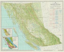
Item is an original map depicting British Columbia published by the National Atlas Information Geographical Services Division.
File consists of notes and reproductions relating to the boundary survey done by A.O. Wheeler, who was employed by British Columbia Government as a surveyor in 1922 to survey the boundary between British Columbia and Alberta.
The map depicts the biotic regions and forests in British Columbia.
Item is issue Vol. 2 No. 4 from February 1912 of the "British Columbia Bulletin of Information", a promotional mouthpiece of the Natural Resources Security Company. The publication is self-described as "About the vast natural resources and commercial, agricultural and mining progress, together with a synopsis of the laws regulating public lands, timber, coal and other minerals, and current record of development in British Columbia, Alberta and Saskatchewan for the business man, the farmer and the investor". The headline of this issue is "B.C. Government Guarantees Bonds of Railway to connect Fort George with Vancouver". The Natural Resources Security Company was a development company that sold a significant amount of land in Fort George.
File contains information on BC Cellulose in relation to the Skagit River.
Includes:
- Handwritten “General Itinerary for Royal Visit to Prince Rupert, Monday May 10th 1971”
- “Royal Visit – Prince Rupert, Itinerary #3”
- Itinerary: “The Queen and the Duke of Edinburgh Accompanied by The Princess Anne, Royal Tour of British Columbia, 3 May to 12 May 1971”
- Report to City Council re: Preliminary planning for the Centennial Royal Visit submitted by Iona Campagnolo, Royal Visit Co-ordinator
- Report of Royal Visit Co-ordinator, Mrs. Iona Campagnolo
- Preparation for Royal Visit rehearsal, March 26th and 27th (1971)
- “Royal Visit- Prince Rupert, May 10th, 1971, Itinerary #6”
- Letter to Iona Campagnolo from Will Hankinson re: planning Royal Visit (includes “Report of Will Hankinson re: questions asked of Royal Tour Visiting Legion”), 1971
- Annotated itinerary for May 10, 1971 Royal Visit, dated March 9, 1971
- Page 1 of letter outlining accreditation procedures for news organizations to apply to accompany the Royal Visit throughout British Columbia, 1971
- Hand rendered sketch re: set-up of Royal Visit
- Handwritten notes re: planning for the Royal Visit
- News clipping: “Royal family to visit Prince Rupert in May”, The Prince Rupert Daily News, 1971
- Copy of letter to Joe Antonelli, Past President, Prince Rupert Society from Iona Campagnolo, Royal Visit Coordinator re: request to read letter, March 24, 1971 (includes attached letter to the Prince Rupert Society from Iona Campagnolo, Royal Visit Coordinator re: announcement of Royal Visit)
- Copy of letter to Bill from Iona Campagnolo re: copy of preliminary planning for Royal Visit, February 19, 1971
- Copy of letter to Messrs. Tyrell, Gadsby and Simmons, Deputy Provincial Secretary’s Office, from Iona Campagnolo, Royal Visit Coordinator re: request for city map, March 10, 1971
- Copy of letter to L.J. Wallace, Deputy Provincial Secretary from Prince Rupert Mayor P.J. Lester re: appointment of Iona Campagnolo as Royal Visit Co-ordinator, February 17, 1971
- Copy of letter to Doctor Large from Iona Campagnolo, Royal Visit Coordinator re: initial planning report, February 16, 1971
- Copy of letter to Prince Rupert Chamber of Commerce from Iona Campagnolo, Royal Visit Coordinator re: media plan, March 1, 1971
- Copy of letter to Mr. E.J. Semmens, Deputy Provincial Co-ordinator Royal Tour from Iona Campagnolo, Royal Visit Coordinator re: special presentations, March 29, 1971
- Copy of letter to Prince Rupert Public Library Board from Iona Campagnolo, Royal Visit Coordinator re: official opening by Princess Anne, March 29, 1971
- Copy of letter to Mr. M.N. McLeod, Mill Manager, Canadian Cellulose Co. Ltd., from
Iona Campagnolo, Royal Visit Coordinator re: thank you, March 29, 1971 - Handwritten copy of letter to Mr. Charles Dudaward from Iona Campagnolo, Royal Visit Coordinator re: painting, 1971
- Copy of letter to Hon. W.H. Murray, Speaker of the House, Prince Rupert Mayor P.J. Lester re: appointment of Iona Campagnolo as Royal Visit Co-ordinator, January 8, 1971
- Copy of letter to Prince Rupert Mayor P.J. Lester from Philip (?), H.M. Yacht Britannia at Sea re: command from the Queen to send a portrait for Prince Rupert as a memento of their visit, and general thank you, May 11, 1971
- Newspaper clippings:
- “Mayor Peter J. Lester” (The Prince Rupert Daily News, ca. May 1971?)
- Pages 1-6 of The Daily News, May 11, 1971 featuring the Royal Visit
Map depicts the climactic regions of British Columbia which includes the coast, interior, and the northwest.
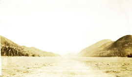
Photograph depicts a view of the water looking toward forested and mountainous coastlines. Handwritten annotation below photograph reads, "BC Coast view".
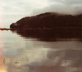
Photograph depicts a coastal landscape, possibly in northern British Columbia or Haida Gwaii.
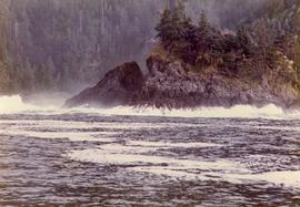
Photograph depicts the British Columbia coastal shoreline, possibly near Haida Gwaii.
Item is a photocopied version of "British Columbia Cross Country Ski Area Study" prepared by Nordic Group International under Canada-British Columbia Tourism Industry Development Subsidiary Agreement.
File consists of notes and typed documents relating to the British Columbia Ecomuseum Symposium.
Series consists of material regarding the BC Electric Railway (1897-1961) and its successor, the BC Hydro Railway (1961-1989). Includes information about BCER interurbans, the Granville Island street railway, and the Nelson Electric Tramway.
File consists of notes, clippings, and reproductions relating to the British Columbia Express Company. Barnard's Express, later known as the British Columbia Express Company or BX, was a pioneer transportation company that served the Cariboo and Fraser-Fort George regions in British Columbia, Canada from 1861 until 1921.
File consists of "Comments and policy decisions by the Forest Policy Advisory Committee on the Recommendations of the Pearse Royal Commission," May 16, 1978.
Subseries consists of records regarding British Columbia Forest Products that were created or accumulated by Adam Zimmerman during his tenure as an Executive Director of the company after it was acquired by Noranda in 1969. Includes annual reports, director's meeting materials, proposals, financial records, and information relating to possible acquisitions of various companies. Also contains records regarding BC Forest Products' acquisition by Northwood Pulp (Noranda).
British Columbia Forest Products Ltd.Item is a BC Forest Service beverage coaster.
A b&w map, index to the Interim Forest Cover Series and the Forest Inventory Area Reference System. Summary data will be referred to the region and compartment outlined and numbered on the map. Region Numbers, Compartment Numbers and Map Sheets of the National Topographic Series are shown on this map.
Map depicts annotations of the freight-way routes throughout British Columbia. These routes include: the Garnet Enterprise Truck Haul from Vancouver to Terrace, the Canadian Freightways from Vancouver to Edmonton to Alaska; the Lindsay Transfer from Terrace to Dease Lake and Telegraph Creek; and the Northland Navigation roll-on and roll-off service.
Item is an original report by the BC Min. of Agriculture, Fisheries and Food entitled "British Columbia Grains and Seeds Strategy: An Industry Development Plan".
File consists of notes, clippings, and reproductions relating to British Columbia historical bibliographies and reference material. Includes: "Rural British Columbia: A Bibliography of Social and Economic Research" typescript document compiled by Dean S. Goard (1967); "Photo chronicler of B.C. a century ago" clipped article from Canadian Photography magazine (Feb. 1977); and "A Guide to British Columbia Stop of Interest Plaques" pamphlet by the Parks Branch of British Columbia (1969).
File consists of notes and printed emails relating to the British Columbia Historical Federation.
File consists of notes and reproductions relating to the British Columbia Historical Federation 2006 Annual Conference in Kimberley. Includes: "Kimberley Historic Calendar" prepared by the Kimberley Heritage Museum (2005).
File consists of notes, clippings, and reproductions relating to the British Columbia Historical Federation (BCHF) conference of 2003. Includes: the 2003 BCHF conference schedule, titled "Work and Society: Perspectives on Northern BC History" (May 2003); "RE: BC Historical Federation Conference" typed letter from the Regional District of Fraser-Fort George to Kent Sedgwick (24 Feb. 2003); and "Organizing Committee Members" typed letter from the City of Prince George to Kent Sedgwick (17 Feb. 2003).
File consists of an issue of the "British Columbia Historical News" along with a handwritten note, photocopy, and a postcard.
File consists of research materials, mostly photocopied, notes, and related correspondence.
File consists of selected correspondence, mailings, newsletters, pamphlets and workshop information from the British Columbia Institute of Agrologists (BCIA). Gary Runka was a long-time BCIA member. Includes issues of the British Columbia Institute of Agrologists (BCIA) Newsletter, the BCIA Special Report for the 65th Annual General Meeting, workshop materials for the BCIA 2012 ethics workshop, and the BCIA Committee on Principles of Stewardship Report to Council (29 March 2010).
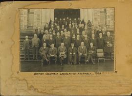
Photograph is adhered to cardboard matting and has a hand drawn "frame" decorating it's perimeter. Handwritten annotation on the recto of the matte, directly under the photograph, lists the names of the photo subjects.
File consists of notes and reproductions relating to maps and mapping in British Columbia. File primarily consists of resources from the University of Northern British Columbia, the College of New Caledonia, the Prince George Public Library, and printed secondary sources for where to find maps, mapping techniques, how to produce maps, and surveying processes. Includes: "Prince George and District map collection finding aid" typescript document from the Fraser-Fort George Regional Museum and Archives (Oct. 1989).
The map depicts the highest mountains in British Columbia; includes the Rocky Mountains, the Northern and Southern Plateaus, and the Mackenzie Mountain area.
File consists of material regarding the British Columbia Museum of Mining and the Britannia Copper Mine. Predominantly consists of tourist pamphlets, commemorative publications, photocopy reproductions, excerpts from books, and clippings from periodicals.
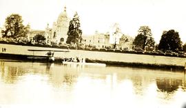
Photograph depicts a view from the water of the Parliament buildings in Victoria BC. Possible sea plane docked in front centre.
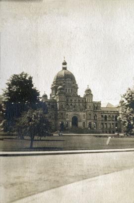
Photograph depicts the British Columbia Parliament Buildings in Victoria, BC.
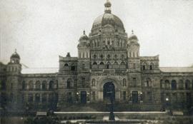
Photograph depicts the British Columbia Parliament Buildings in Victoria, BC.
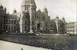
Photograph depicts the British Columbia Parliament Buildings in Victoria, BC.
Item is a map compiled and produced by Geographic Division, Surveys and Mapping Branch, Department of Lands, Forests, and Water Resources ; geological and physiographical data supplied by Dept. of Mines and Petroleum Resources, Victoria, B.C. (1964).
File consists of provincial and regional maps of British Columbia relating to railways, which consist of photocopy reproductions from books and hand drawn works by Davies. Includes a series of articles by Davies published in The Sandhouse entitled: "An Interesting Tale: An Old Map is Discovered"; "Railways Around the Bottom End of Kootenay Lake"; "Railways in the Slocan Region"; "Nelson, Trail, and Thereabouts"; "Kettle Valley Railway Routing: The Theory"; "Competition, Then Compromise: The meshing of the V.V.E.R. and the K.V.R."; "Centenary of Crow's Nest Pass Railway"; and "E&N Developments on Vancouver Island".
File consists of notes and reproductions relating to British Columbia's provincial government land reserves. Includes material regarding railway land reserves on the Upper Fraser in 1912; homesteading land reserves; and pre-emptor land reserves for settlement. File predominantly consists of photocopied clipped articles regarding provincial government land reserves in northern and central British Columbia, particularly surrounding Fort George.
Series consists of records generated by the British Columbia Provincial Police Veteran's Association (BCPPVA).
Fonds consists of 5 boxes of materials related to the BC Provincial Police, including bound volumes of "Shoulder Strap," "Off Patrol" newsletters, General Orders 1923-1950, Constable Correspondence 1904-1909, and Criminal Investigation Branch Vol. 1-14.
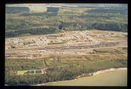
Image depicts an aerial view of the BC Rail, in Prince George, B.C. It is now known as CN Rail.
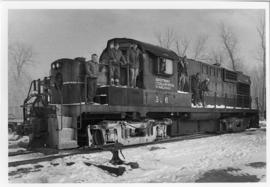
Photograph depicts a stationary B.C.R. locomotive # 586 on a wintry track with seven men on board posing for a photo. Part of a set of 17 black & white photographs of British Colombia Railway & its precursor, Pacific Great Eastern Railway (1912 - 2004) in British Columbia. Photos depict locomotives, railroad cars, and crew members.
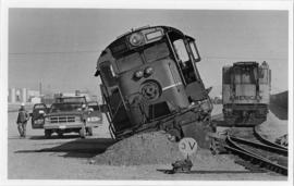
Photograph depicts B.C.R. locomotive # 586 derailed with two men arriving in a company truck. Gravel and switch is visible in the foreground while industrial storage tanks are visible in the background. Photographer: "Brock Gable" stamped in red on verso. Typed note on verso reads: "When we say May Day, we mean May Day.......specifically May1, 1985. Our locomotive, BCR # 586 made the front page of the "Citizen" that day. though not the way anyone intended. In fact, it was downright embarrassing and unflattering. Nearing the end of its career, # 586 was involved in a minor hist and run in the BCR yard and parted company with the rails. As is evident in the picture, BCR's big hook" is standing by and help is on the way. No! we don't know if anyone got the other guy's license. (Photo Credit: Brock Gable ///Citizen). Part of a set of 13 black & white photographs of British Colombia Railway & it's precursor, Pacific Great Eastern Railway (1912 - 2004) in British Columbia. Photos depict locomotives, railroad cars, and crew members. «
Consists of photographs depicting various scenes on the Pacific Great Eastern Railway and British Columbia Railway (later known as BC Rail).
The British Columbia Railway (BC Rail) series consists of promotional ephemera material, employee time tables, fare rates and multiple forms, used and unused, pertaining to daily train movements and BCR operations. Several employee manuals, employee examination material, employee seniority listings, and union agreements are also contained within. Three plans detail various BC Rail sites.
British Columbia RailwayGovernment map depicts railway lands, lands "disposed of", grazing leases, and timber berths. Shows the British Columbia 'railway belt' running from Greater Vancouver to Field, B.C.
Map depicts railways in British Columbia, with insets for the Lower Mainland and the Kootenays.
