Showing 21795 results

Archival description
2012.05.01.01.30 · Item · [ca. 1967]
Part of Columbia Cellulose Company, Ltd. fonds

Item is a map that distinguishes the regions covered by Tree Farm Licence No. 1 granted to Columbia Cellulose and Three Farm Licence No. 40 granted to Skeena Kraft. Major locations indicated in this map include: Prince Rupert, Terrace, Hazelton, Smithers, Kitimat, Skeena River, and Nass River. Railway routes are also shown.

Map Board?
2012.13.1.133.11 · Item · 1985
Part of J. Kent Sedgwick fonds

Image depicts a man holding up a board which appears to have maps of the Cottonwood Park on it.

2020.4.2.1.08 · File · 21 Aug. 1973
Part of G. Gary Runka fonds

File consists of a speech given by Gary Runka to the Agricultural Institute of Canada entitled "Managing Our Land Resources for Survival and Pleasure".

Commentary on this speech by Barry Smith of the Ministry of Agriculture and Lands:
"This speech is aimed at land use planning and planners, and GGR provides his definition of "ecology" which includes:
"...the basic characteristics of the land - its geology, soils, climate, vegetation, and animal life, including the devil that does the most damage, man. It also includes the interrelationships within these basic characteristics and of course this is where the word "complexities" comes in. There are no two places where these components combine in exactly the same manner and each ecological unit, if you like, is unique."

GGR mentions the importance of considering options.

This package includes a copy of the speech as well as a second, 2 page document, with the same title in which GGR is noted as 'Manager of the BC Land Commission'. This second document is largely a summary of the more formal speech."

2020.4.2.1.67 · File · Sept. 2009
Part of G. Gary Runka fonds

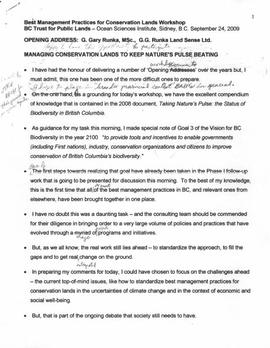
File consists of a speech given by Gary Runka entitled "Managing Conservation Lands to keep Nature's Pulse Beating" for the BC Trust for Public Lands.

Commentary on this speech by Barry Smith of the Ministry of Agriculture and Lands:
"GGR's was the opening address at the workshop. While this speech is focused on the issue of Best Management Practices (BMP), comments about the ALR are woven into the presentation. This copy of the speech appears to be a draft version and includes several hand-written amendments with some points crossed out.

In the opening, mention is made of the grounding that the 2008 document "Taking Nature's Pulse: the Status of Biodiversity in British Columbia" has provided the workshop.

This speech provides an historical overview of the broader provincial context of BMP's drawn from 40 years of GGR's experience. The following is a selection of his comments:

  • BMP's are part of the "tool kit" of policy and management mechanisms that have been experimented with over the decades to try to rationalize human economic activities with the needs of other species and overall ecosystem well-being.
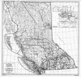
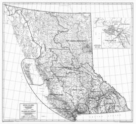
  • Historically the 1960s and 70s Canada Land Inventory program that emerged from the Resources for Tomorrow conferences was a significant benchmark mapping land capability for agriculture, forestry, recreation, wildlife and waterfowl use (of which GGR was centrally involved).
  • Within BC, using the CLI, the 1973 Land Commission Act authorized the establishment of a provincial zone to protect those sacred lands with the biophysical capability to grow food.

One point was not used in the speech (crossed out). The speaking notes, however, include a reference to the Land Commission legislation originally having a complimentary conservation objective that had since been removed. GGR makes the point that still having the conservation function may have contributed positively to current struggles to preserve natural habitat. Regardless, it is noted that the concept of the ALR has been a unique, effective and, most importantly a lasting management practices tool for conserving lands identified as biophysically significant.

A further selection of points made:

  • We need to evolve BMP tools that are adaptable yet resilient in the face of changing knowledge, climate change and ever-evolving social priorities.
  • Traditionally, planning has been most associated with local governments in the form of official community, regional and neighbourhood plans and as an outgrowth of the ALR - Agricultural Area Plans.
  • Environment Farm Planning - by agreeing to engage in the conservation planning process, participating farmers and ranchers have qualified for funding to carry out farm improvements benefitting conservation and biodiversity.
  • The work of the Delta Farmland and Wildlife Trust is outlined (p. 8)
  • "My final words of wisdom are - Be focused and be pragmatic"
  • "Many of the best intentions to standardize land management practices for conservation lands have been great on paper - but never quite make it on the ground."
  • And, if BMP are not implemented effectively on the ground, they cannot play the critical role they need to play in 'keeping nature's pulse beating'."
2000.1.1.2.1.086 · Item · October 1952
Part of Cassiar Asbestos Corporation Ltd. fonds

Photograph depicts a mill with scaffolding on the left side of the building. A second scaffolding structure is in the foreground with trees and mountains in background. Typed annotation taped to verso of page stapled to photographs: "View of mill building looking west."

2000.1.1.2.1.110 · Item · 20 August 1952
Part of Cassiar Asbestos Corporation Ltd. fonds

Photograph depicts pipes laid in ground on wood structure, power house and men on scaffold in background. Building materials on left in foreground. Corresponding note on accompanying photo description page: "August 20th: 7. Installing water pipes from water tank to Power House. Oil tanks on left. Looking southeast."

Manager's Photos - Warehouse
2000.1.1.2.1.309 · Item · March 1952
Part of Cassiar Asbestos Corporation Ltd. fonds

Handwritten annotation in blue ink on recto of photograph: "Warehouse in construction." Photograph depicts two men working in warehouse interior, and one man sitting on top of wall with sledge hammer raised. Miscellaneous building tools and supplies throughout.

Manager's Photos - Warehouse
2000.1.1.2.1.306 · Item · March 1952
Part of Cassiar Asbestos Corporation Ltd. fonds

Handwritten annotation in blue ink on recto of photograph: "Foreground warehouse under construction and in the background lays asbestos." Photograph depicts two men walking towards warehouse building. Walls are erected though roof is not. Steel drums and equipment under tarp shelter in foreground, trees and mountaintops in background.

2000.1.1.2.1.067 · Item · [between December 1952 and March 1953]
Part of Cassiar Asbestos Corporation Ltd. fonds

Photograph depicts equipment believed to be in the concentrator, dryer, or mill building. Typed annotation taped to verso of page stapled to photograph: "Close-up of vacuum hood which sucks fibre away from the rock."

2000.1.1.2.1.113 · Item · 25 August 1952
Part of Cassiar Asbestos Corporation Ltd. fonds

Photograph depicts concrete walls in ground, building materials on right. Corresponding note on accompanying photo description page: "August 25th: 10. Concrete walls for truck dump and coal handling bin. Power house in background. Looking north from mill roof."

2000.1.1.2.1.203 · Item · 11 June 1952
Part of Cassiar Asbestos Corporation Ltd. fonds

Photograph depicts men building truck dump in foreground, building believed to be power house in background. Corresponding note on accompanying photo description page: "Pictures taken June 11th: (3) Framing water tank tower. Water well in foreground and tower timbers and oil tanks in background. Looking east." [Note believed to be incorrect.]