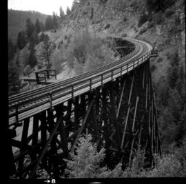
Photograph depicts the CPR Kettle Valley Railway in Myra Canyon. It shows the a wooden trestle fitted with a sidewalk, which at 434 ft. long is the longest one in the canyon. It is located at mile 85.9. The view is looking north.
Photograph depicts a trestle bridge for road traffic leading to the Second Narrows Bridge in Vancouver, BCThe shot is taken from the south bank.
File contains correspondence to Brian Fawcett from Trent University. Includes a letter to Brian Fawcett from Trent University regarding a goods and service tax small supplier declaration form. Faxed copy dated September 19, 1993.
File consists of a paper by Michael Bradford entitled "Trends in the Abundance of Chinook Salmon of the Nechako River, British Columbia".
Aerial view, Yellowknife, Northwest Territories
Sunset and darkness on Trembleur Lake, Northern British Columbia
Image depicts a west-looking view of Trembleur Lake.
File consists of audio and visual material relating to the interview of Trelle Morrow conducted by Kent Sedgwick. Also includes an audio cassette entitled "Trelle Morrow interview"; an audio microcassette entitled "Kent - CBC -Trelle"; and a CD-ROM entitled "Trelle Morrow interview colour photos" depicting photographs of the interview.
The item is an audio cassette recording an interview with Trelle Morrow.
The item is an audio compact disc interview with Trelle Morrow.
Includes an audiocassette and a CD copy of an interview conducted by Kent Sedgwick with Trelle Morrow on the history of architectural design in Prince George.
Morrow, TrellePhotograph depicts Trelle Morrow standing in the Soda Creek cemetery. Annotation on verso: "Trelle M. at cemetery, Soda Creek, 2010.'
Photograph depicts Trelle Morrow and Jim Rankin at the Soda Creek cemetery. Annotation on verso: "Trelle M. and Jim Rankin at Soda Creek cemetery, 2010."
Habitat of Populus deltoides ? at Cottonwood Island Park
Photograph depicts trees standing in foreground, river and hills visible in distance.
Image depicts a stand of trees and a shed at Island Cache.
Image depicts two old houses surrounded by numerous trees at an uncertain location.
Image depicts a green car among some trees on Cottonwood Island.
Bench visible in left foreground.
Image depicts numerous trees in an uncertain location; the slide itself is labelled "T.T. Cutting," possibly meaning "Telegraph Trail Cutting."
Image depicts a few trees, with what is possibly the Northwood Pulpmill in the background, in Prince George, B.C.
Image depicts a small copse of trees boxed in by very small concrete barriers somewhere in Kettle Valley, B.C.
Item is a photograph of a tree stump apparently eaten through by beavers.
Large tree trunk and smaller saplings silhouetted against Summit Lake, forest visible on opposite shore. Handwritten caption beside this photo reads: "Sumit Lake."
Item is a report entitled "Tree Length Skidding and its Influence on Residual Forest Stands in the Fort George Forest District" by L. deGrace of the British Columbia Forest Service.
Item is a report entitled "Tree Length Logging as a Silvicultural Problem in the Uneven-aged Spruce-Balsam Type of the Prince George District" by A.R. Fraser of the British Columbia Forest Service.
Photograph depicts a tree growing on a stump at Mill Bay Cannery on the Nass River. Handwritten annotation below photograph reads, "a tree growing on a stump, Mill Bay, BC".
This CD-ROM contains the digital publication, "Tree Fruit Suitability Digital Atlas: Tree Fruit Suitability in the Okanagan, Similkameen and Creston Valleys". Software install on a compatible computer is required to access the content.
Prince George, British Columbia
File contains a photocopied version of "Tree Farm Licence No. 29 - Eagle Lake Sawmills Ltd. Cutting Permit Application No. 7". Although this item is not related to the Aleza Lake Research Forest, it is relevant to forest history in the Prince George area and therefore retained by the Society.
Slide depicts cleared ground and felled trees in a forested area, likely at the Aleza Lake Experiment Station.
<i>Xeromphalina campanella</i> and green moss covering a fallen tree
Item is a photograph of a large tree cutting machine.
Image depicts two unidentified individuals examining a thick log still attached to the machine that cut it down. It is located somewhere in Prince George, B.C.
Photograph depicts tree-covered mountain ranges in winter.
Detail of peeling bark off of <i>Betula tremuloides</i>
File consists of a copy of Treaty no. 8 originally created on June 21, 1899.
File consists of:
- Indian and Northern Affairs Canada. "Building a New Relationship with First Nations in British Columbia: Canada's Response to the Report of the B.C. Claims Task Force", 1991.
- BC Ministry of Aboriginal Affairs. "In Fairness to All: Moving Towards Treaty Settlements in British Columbia", 1991.
- Ministry of Indian Affairs and Northern Development. "Aboriginal Self-Government Federal Policy Guide", 1995.
- Proceedings documenting a presentation by Dr. Robin Fisher to the Select Standing Committee on Aboriginal Affairs at the BC Legislative Assembly on Monday Oct. 28, 1996 in Smithers, BC
- Map prepared for the Ministry of Aboriginal Affairs showing the territory boundaries via a "Statement of Intent for the Lheit-lit'en Nation", 1996.
- BC Ministry of Aboriginal Affairs. "Glossary of Treaty-Related Terms", 1997.
- First Nations Education Steering Committee, B.C. Teacher's Federation. "Understanding the B.C. Treaty Process: An Opportunity for Dialogue", 1997.
- BC Treaty Commission Annual Report, 1995-1996
- BC Treaty Commission Annual Report, 1997
- Federal Treaty Negotiation Office. "The Treaty Negotiation Process", 1997.
- A commemorative issue of "Hak'ak'a'a" newsletter (August 4, 1998) published by the Nisga'a Tribal Council
- Issues of the Canadian Federal Treaty Negotiation Office publication "Treaty News", including issues from April 1995, July 1996, December 1996, July 1997, December 1997, March 1998, June 1998, October 1999, June 1999, March 2000, June 2000, Winter 2001