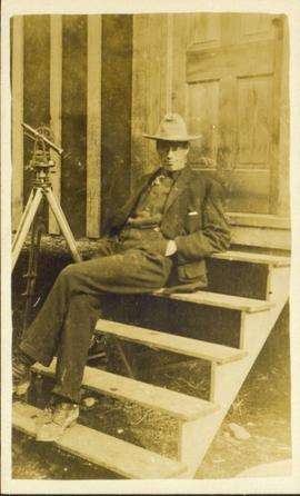
Photograph of a happy man reclining on a short exterior staircase. A surveyor's transit can be seen in the background.
Series consists of maps, plans, and drawings collected by faculty in the UNBC School of Planning and Sustainability. The majority of these maps reflect the planning history of the City of Prince George and include large format, hand-drawn plans created by the City Planning Department from the 1970s and 1980s. Maps from City of Prince George Official Community Plans are also included.
File consists of an oral history given by Marie Paquette, which was gathered as part of Dr. Mike Evan's oral history project with the Prince George Metis Elders Society. Includes consent forms, transcripts, and the recorded oral history on the original cassettes.
Item is an original copy of "Moran Dam Environmental Analysis" by the Cariboo Land Capability Analysis Committee and Intersector Special Study Committee of the British Columbia Canada Land Inventory. The committee members were A. Bedwany, D. Benn, D. Blower, R. Marshall, and G. Runka. Includes 24 original colour photographic prints pasted into the report.
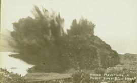
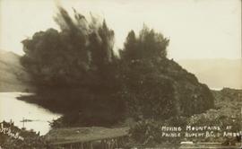
Photograph of a large explosion on a rocky shoreline. A bridge is visible in the foreground and a body of water is partially visible in the background. Annotation on recto reads: "McRae Bros Moving Mountains at Prince Rupert BC Apr 24th"
Photograph of a large explosion on a rocky shoreline. A bridge is visible in the foreground and a body of water is partially visible in the background. Printed annotation on recto reads: "McRae Bros Moving Mountains at Prince Rupert BC Apr 24th" Handwritten annotation on verso reads: "Rupert. July 17 1913. Dear [illegible]. Just a card for that album if you've got any room left by now. This is one of the blasts for the clearing of the drydock up here. [Illegible] W.M." Postcard is addressed to: "Miss C.M. Ranip[??] 931 Northlane Av.[sic] Seattle Wash." Two Canadian one cent stamps are affixed on verso. Postmark reads: "Prince Rupert BC. PM Jul 17 13."
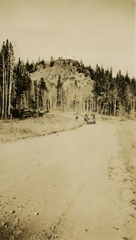
Photograph depicts Mount Begbie, noted by Wyness to be the highest point on the Cariboo Highway at mile 85. Mount Begbie is located at approximately 51°28'33''N, 121°22'00''W, on the east side of Cariboo Hwy, between 70 Mile House and 100 Mile House, in the Lillooet Land District. Wyness annotated this photograph with the statement that they "tied this one in"; 'tying in' is a land survey term, implying that the crew may have also been surveying in this area.
File consists of notes and reproductions relating to Mud River Elementary School. Also includes photographs depicting old Mud River buildings and roads.
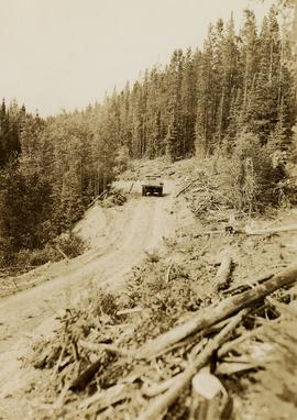
Photograph depicts a work vehicle on new road during road making north of Stuart Lake.
Photographs within this file document stern wheelers operating in Northern BC from ca. 1901 - 1915.
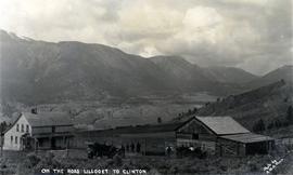
Photograph depicts a ranch home and barn along the road from Lillooet to Clinton. The location is believed to be a homestead 2 miles south of Pavilion Station. Two cars are parked beside the property, with a number of men nearby.
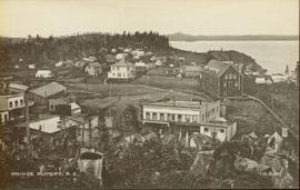
Wide angle photograph of many buildings scattered in a clear cut area. Foreground shows several businesses, including "Kelly Carruther's Supply" and "Prince Rupert Hardware and Supply Co." Some remaining forest is visible in the background. Annotation on recto reads: "Prince Rupert, BC 1659."
File consists of notes, clippings, and reproductions relating to the original Pacific Great Eastern Railway line. Also includes photographs depicting various dirt roads (2001-2010).
File consists of correspondence with multiple parties including Wright Parry Taylor & Fuller Engineering, Paldi Estates, and the Cowichan Valley Regional District. Includes notes, sewage and waste disposal assessments, state of title certificate, and applications.
File consists of a water supply and sewage disposal study for the townsite of Paldi. Includes maps, correspondence, water licensing information and application, and Bayview Village advertising brochure.
Consists of two photograph albums that illustrate Parker Bonney's early years as a Forest Engineer. Includes photographs of the expedition to the Nass Valley undertaken by Parker Bonney, Sam Brown, and others. May also include photographs of later surveying expeditions.
Bonney, ParkerFile consists of clippings related to the Peace River region. Also includes photographs taken by Kent Sedgwick depicting Mackenzie, BC and the Peace River region (2003).
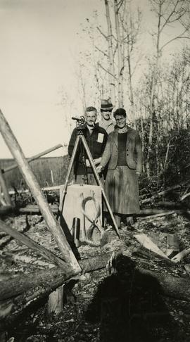
Photograph depicts (from left to right) Philip Monckton, Gordon Wyness, and Lavender Monckton at the Beaverly Geodetic Station, 7 miles west of Prince George. Surveying equipment (tripod, theodolite, and wire) are stationed at centre.
Gary Runka was a hobbyist photographer and documented his work and personal life through photography as he travelled across every region of British Columbia. His photographs document the evolution of British Columbia communities and regions over a 30 year period. Gary Runka's core interest was land and changing land uses. Many of his photographs tell a story of urban edge and/or natural resource compatibility/conflict. There are also a substantial number of photographs related to soils, including soil profiles, soil erosion and land (topography, drainage etc.) capability for agriculture. The collection also includes specific client-related photos, tied to Land Sense Ltd. client file job numbers.
The collection also documents personal travels and hiking trips throughout British Columbia and backpacking in some historic areas, such as the West Coast Trail and Cape Scott. These photographs also represent land evolution over time, including extent of alpine glaciation or biodiversity/plant species inhabiting the area.
Series consists of photographs of the Island Cache Reunion on June 12-13, 1999.
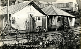
Photograph of post office and neighbouring building. Both buildings are composed of wood and tent materials. Annotation on recto reads: "Post Office & Customs House, Prince Rupert, BC."
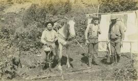
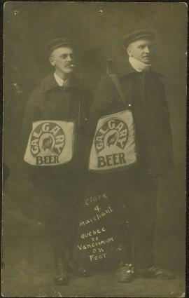
Photograph depicts two men posed with "CALGARY BEER" bags slung over shoulders. Handwritten annotation on verso of photograph: "Clark & Marchant Quebec to Vancouver on Foot", on recto: "To H F Glassey With Every Good wish. from Leo Marchant. Pearson's Magazine 1909."
Subseries includes research material created and collected by Kent Sedgwick relating to land survey, development, and settlement in Prince George and British Columbia. Land surveys were conducted in British Columbia by surveyors George Dawson, the North Coast Land Company, Alfred R.C. Selwyn, and the Geological Survey of Canada during the late 19th and early 20th centuries. James C. Anderson and engineer J. Gill conducted topographical surveys for the Grand Trunk Pacific Railway on Fort George and the Indian Reserve. Surveyors and land plot companies developed the land for sale to promote settlement in the area. Also includes materials regarding the continued development of the City of Prince George throughout the 20th century. The files primarily consist of newspaper clippings, research notes, and photocopied documents.
File consists of appraisals, indentures, and surveys of properties in the Prince George area. Includes two photographs taken at Fraser Lake.
The Prince George Railway & Forestry Museum Society Collection consists primarily of textual, photographic, and cartographic records related to the regional developments of the railway industry in Northern BC. A predominant portion of the collection is made up of material from the Canadian National Railway; other railways represented include the Pacific Great Eastern Railway, the British Columbia Railway (BC Rail), the Grand Trunk Pacific Railway, the Grand Trunk Railway, the Intercolonial Railway, and the Okanagan Express. Significant geographical areas covered include Prince George, the Peace River Region, Terrace, Bulkley Valley, Hazelton and Prince Rupert.
The forestry industry is represented in the collection with operational and financial records from Fyfe Lake Sawmill Ltd., which operated southwest of Prince George in the 1950s.
The collection has been organized into series according to creator, each of which also has been arranged to subseries, file and item level, where applicable. This collection consists of eight series, as follows:
1) Canadian National Railway
2) Grand Trunk Railway
3) Pacific Great Eastern Railway
4) British Columbia Railway (BC Rail)
5) Canadian Pacific Railway (CPR)
6) Intercolonial Railway
7) Fyfe Lake Sawmill ltd.
8) PGRFM
9) Photographs
Subseries contains material collected and created by Kent Sedgwick for research regarding various areas surrounding Prince George. Includes materials on the Crooked River area; Summit Lake; Ferguson Lake; Chief Lake; Salmon Valley; Mud River; Beaverly; Buckwater; Chilako River; Indian Reserve no. 4; Blackburn; Pineview; Stone Creek; Red Rock; Woodpecker; and Hixon. The files primarily consist of research notes and photographs depicting the communities.
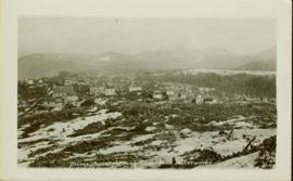
Wide angle photograph of Prince Rupert sometime during the winter. There is snow on the ground and a marge mountain range is visible in the background. Annotation on recto reads: "Prince Rupert looking East from Waterworks J.D.A Pho 5/2."
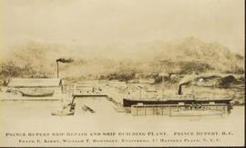
Photo of entire ship building plant, including several vessels in the foreground. Hills are visible in the background. Annotation on recto reads: "Prince Rupert Ship Repair and Ship Building Plant. Prince Rupert BC. Frank E Kirby, William T Donnelly, Engineers. 17 Battery Place. NYC."
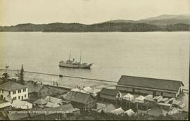
Photograph of a small vessel on the ocean with a dock and harbour buildings in the foreground. Tents and piles of lumber can be seen among the buildings. Annotation on recto reads: "The Wharf, Prince Rupert, BC. 1657." Printed annotation on verso reads "The Wharf, Prince Rupert, BC J. Howard A. Chapman, Victoria. BC. 1657."
Series consists of print photographs created or collected by Gary Runka over the course of his personal and professional life. Includes school portraits, sporting event photographs, and work-related group portraits. Also includes aerial photographs of the West Coast Trail.
Kent Sedgwick’s research subject files contain original research notes, interviews and oral histories, news clippings, and collected primary and secondary sources. The series also includes both original and reproduction photographs, audio recordings, and maps. The subject files primarily relate to the history, urban planning, and historical geography of the Central Interior of British Columbia, especially Prince George area and the East Line communities over the course of the 20th century. They also include extensive notes on geographic features, landscapes, interpretative trails, architectural history, industrial history, history of Western exploration and land survey, and the First Nations history of the region.
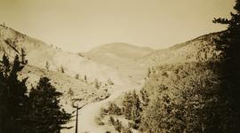
Photograph depicts the rock formations along the Cariboo Road north of Cache Creek. Wyness notes that the rock may be sandstone; there may be red iron oxide visible in the formation.
File consists of photographs depicting the Salmon River Portage. Includes depictions of potential past mill sites, overgrown fields, and derelict buildings.
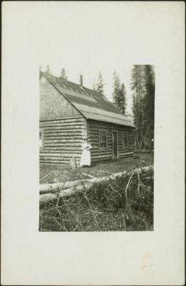
Photograph depicts Sarah Glassey, holding her fox terrier, and standing at corner of log house. Felled trees in foreground, forest trees in background. Photograph believed to have been taken on the 160 acres of land which Sarah purchased in the Kispiox Valley in 1911. She became the first single woman to pre-empt land in British Columbia. This house was built in a year with the help of a Gitxsan Elder.
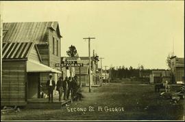
Photograph depicts a street scene along Second St. in Fort George. Wagons line the dirt road which is flanked by wooden buildings. A group of unidentified men stand on the boardwalk outside of Rigg's Restaurant. Handwritten annotation along bottom of photograph: "Second St. Ft. George".
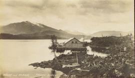
Side view photograph of a small harbor close by a shoreline littered in organic debris. A foggy mountain range is visible in the background. Annotation on recto reads: "Wharf and Harbor Prince Rupert. May 1908 JDA."
Gary Runka was a hobbyist photographer and documented his work and personal life through photography as he travelled across every region of British Columbia. This slide collection documents the evolution of British Columbia communities and regions over a 30 year period. Gary Runka's core interest was land and changing land uses. Many of these slides tell a story of urban edge and/or natural resource compatibility/conflict. There are also a substantial number of slides related to soils, including soil profiles, soil erosion and land (topography, drainage etc.) capability for agriculture. The collection also includes specific client-related photos, tied to Land Sense Ltd. client file job numbers.
The collection also documents personal travels and hiking trips throughout British Columbia and backpacking in some historic areas, such as West Coast Trail and Cape Scott. These slides also represent land evolution over time, including extent of alpine glaciation or biodiversity/plant species inhabiting the area.
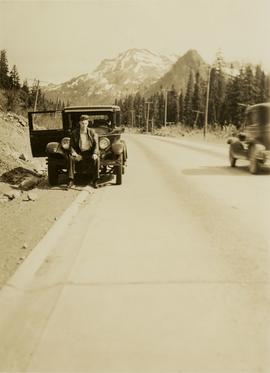
Photograph depicts a man, likely Gordon Wyness, sitting on the front of a 1930 Buick Series 40 car at the Snoqualmie Pass summit.
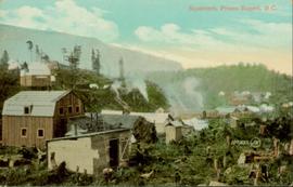
Hand coloured photo of various squatter's shacks and tents, with mountains in the background. Printed annotation on recto reads: "Squatters, Prince Rupert, B.C." Artist's stamp on lower right corner reads: "104,0033 J.V."
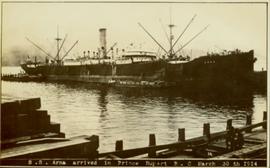
Photograph of ocean liner SS Arna docked in a harbour. Foreground shows two individuals on a dock in the lower right corner and a large pile of lumber in the lower left corner. Annotation on recto reads: "S.S. Arna arrived in Prince Rupert B.C March 30th 1914"
File consists of notes and reproductions relating to the Stewart River townsite. Includes photographs depicting newspaper articles about the Stuart River.
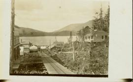
View of the road descending to the waterfront. Buildings and forested area are visible on either side of street. Annotation on recto reads: "Prince Rupert BC. '07."
