2020.4.6.021.09
·
Item
·
[197-?]
Part of G. Gary Runka fonds
236 results with digital objects
Show results with digital objects
2009.6.13.45.31
·
Item
·
Apr. 1975
Part of The Honourable Iona Campagnolo fonds
Map includes an annotated line indicating the city limits and the crown land surrounding the village of Kitimat.
2023.2
·
Fonds
·
1960-2024
Fonds consists of the research records of Dr. Paul Sanborn, a University of Northern British Columbia faculty member in the Department of Ecosystem Science and Management.
Sanborn, Paul Thomas
2008.6
·
Collection
·
1969, 1980
Collection consists of 1 map of "Status of Sustained-Yield Forestry Programme as at December 31, 1969" by British Columbia Department of Lands, Forests, and Water Resources and 10 pages of handwritten instructions for opening a ranger station in Smithers and annual Forest Insect and Disease Survey, dated 1980.
2012.13.2.20
·
Subseries
·
1980-2011
Part of J. Kent Sedgwick fonds
Subseries includes material collected by Kent Sedgwick regarding the Duke of Sutherland. The Duke of Sutherland is a title in the Peerage of the United Kingdom. The fourth Duke of Sutherland was Cromartie Sutherland-Leveson-Gower who lived from 1851 to 27 June 1913. Toward the end of his life, the 4th Duke began moving his wealth and life to Canada. The Duke owned land across British Columbia and Alberta and contributed to various settlements, including Strathnaver, BC; Windermere, BC; Brooks, AB; and Clyde, AB. The Duke of Sutherland owned the Sutherland Land Company, creating and selling plots in BC and Alberta. He also worked closely with the Canadian Pacific Railway to support immigration and settlement of the area.
2012.13.6.18
·
File
·
1950
Part of J. Kent Sedgwick fonds
Item is a photocopied plan depicting the Eagle Lake Sawmills Ltd. in Giscome, British Columbia with the plan of the sawmill and adjacent buildings, published by Transit Survey by L.C. Gunn and P.J. Klotz.
2012.13.6.17
·
File
·
1925
Part of J. Kent Sedgwick fonds
Item is a photocopied 1925 fire insurance plan depicting the Eagle Lake Spruce Mills Ltd. in Giscome, British Columbia published by the British Columbia Fire Underwriters Association.
2012.13.6.10
·
File
·
1993
Part of J. Kent Sedgwick fonds
Item is an original map depicting east central British Columbia published by the Technical Supper Section Surveys and Resource Mapping Branch Ministry of Lands and Parks in Victoria, British Columbia.
2020.4.7.013
·
Item
·
1982
Part of G. Gary Runka fonds
2016.5.1.87
·
File
·
[1970-2015]
Part of Harry Coates fonds
File consists of photocopied documentation for E.P. 646.3 Reciprocal Planting of Spruce Provenances in the Rocky Mountain Trench along with printed satellite maps from Bing Maps. File also includes a map of Buckhorn Barn showing reserve no. EP 505, research & R.N. projects. Map includes annotations for EP 646.3.

2007.1.30.8.1
·
Item
·
[between 1993 and 1997]
Part of Aleza Lake Research Forest fonds

2007.1.30.8.2
·
Item
·
[between 1993 and 1997]
Part of Aleza Lake Research Forest fonds

2007.1.30.8.3
·
Item
·
[between 1993 and 1997]
Part of Aleza Lake Research Forest fonds

2007.1.30.8.4
·
Item
·
[between 1993 and 1997]
Part of Aleza Lake Research Forest fonds

2007.1.60.09.2
·
Item
·
[199-?]
Part of Aleza Lake Research Forest fonds

2007.1.30.8.5
·
Item
·
[between 1993 and 1997]
Part of Aleza Lake Research Forest fonds

2007.1.60.09.3
·
Item
·
[199-?]
Part of Aleza Lake Research Forest fonds
2009.6.13.45.32
·
Item
·
Jan. 1978
Part of The Honourable Iona Campagnolo fonds
Map shows project boundaries in Mont Ste. Marie for proposed sports training centre at a ski resort.
2009.6.13.45.06
·
Item
·
[between 1974 and 1979]
Part of The Honourable Iona Campagnolo fonds
Map depicts Bee Peak, Golden Mountain, Mount Fetterly, Mount Brook, Ear Mountain, Sunday Peak, Graham Inlet, and Taku Arm of Tagish Lake.
2012.13.2.02.33.04
·
Item
·
[1990?]
Part of J. Kent Sedgwick fonds
The item is a reproduction of a survey map drafted in January 1910. The reproduction was likely created in 1990. The subdivision is Lot 936 G. I. Cariboo District, B.C. The area covered is North of Twenty First Avenue, East of Quinn Street, South of Eighth Avenue and West of Carney Street. Annotations highlight "Owner Edgar McMickiny," "696" and "Jordan Brothel" written in red pen pointing to a specific location.
2016.5.5.02
·
Item
·
[197-?]
Part of Harry Coates fonds
Item is a Forest Cover Map, 93J-10-d, annotation on the back reads Carpet Lake. Geographic features include Merton Lake and Peculiar Lake.
2016.5.5.03
·
Item
·
1993
Part of Harry Coates fonds
Item is a Forest Cover Map, 93J-7, annotation on the back reads Summit Lake. Geographical features include Summit Lake and Crooked River.

2006.18.5.06
·
Item
·
1949
Part of Aleza Lake Research Forest Society fonds
Original forest cover map shows timber history in the area of Giscome, BC.
2008.2.1.31
·
Item
·
1917
Part of Northern BC Cartographic Collection
Colour-coded topographic map depicts forest stands of different heights.
2016.5.1
·
Series
·
1941-2018
Part of Harry Coates fonds
Series consists of records pertaining to Harry Coates work and training as a BC Forest Service Research Technician. Series includes documentation for various Sx trials and experimental plots (E.P.) Harry Coates worked on.
2012.13.6.22
·
File
·
1915
Part of J. Kent Sedgwick fonds
Item is a photocopied 1915 map depicting the Fort Fraser Division, published by the British Columbia Department of Lands.
2012.13.6.12
·
File
·
1944
Part of J. Kent Sedgwick fonds
Item is a photocopied 1944 map depicting Fort George, published by British Columbia Department of Lands.
2012.13.6.21
·
File
·
1944
Part of J. Kent Sedgwick fonds
Item is a photocopied 1944 map depicting Fort George, published by the British Columbia Department of Lands.
2012.13.2.02.33.11
·
Item
·
[1990?]
Part of J. Kent Sedgwick fonds
The item is a reproduction of a survey map drafted on 20 Nov. 1910. The reproduction was likely created in 1990. The subdivision is lot 2610 G. I. and part of lots 2507 and 2608 G. I. Cariboo District. The area covered is South of 8th Avenue, East of 19th Avenue, North of 8th Street and West of Quinn Street. Annotations state, "Pl. 847," and various notations regarding lot information.
2012.13.2.14.01
·
File
·
1978-2005
Part of J. Kent Sedgwick fonds
File consists of clippings, notes, and reproductions relating to Fort George Park (renamed in 2015 to Lheidli T'enneh Memorial Park). Includes: "Fort George Park" typescript document; "Plan No17962" reproduction of downtown map and plan no 17962 (1969); "Fort George Park" handwritten notes by Kent Sedgwick; and "Park No. JK 85 Fort George Park" map depicting plans for Fort George Park (28 June 1978).
2020.4.2.3.104
·
Item
·
1997
Part of G. Gary Runka fonds
Item is a reproduction of a draft "Fort Nelson Land and Resource Management Plan", accompanied by an original 1997 "Fort Nelson L.R.M.P. Plan Area" map produced by BC Ministry of Forests for the Fort Nelson LRMP Working Group.

2020.4
·
Fonds
·
1945-2013
This fonds illustrates the life and work of G. Gary Runka and his contributions to the province of British Columbia. Gary Runka was the first General Manager of British Columbia's Agricultural Land Commission and helped establish the provincial Agricultural Land Reserve. After transitioning from a government career to private consulting, Runka provided comprehensive professional services through his land consultancy business, G.G. Runka Land Sense Ltd., offering land capability and environmental assessments, integrated resource management, land and water use conflict resolution, and interdisciplinary land use planning. Described by colleagues as one of BC's most highly respected agrologists and influential land use planners, Runka had a 52-year career working on (or against) an incredible number of landmark projects in British Columbia, such as the Site C Project. Gary Runka’s partner in life and vocation, Joan M. Sawicki, worked with Gary on many of these projects—as well as her own; her contributions are also represented throughout the records of this fonds.
Gary Runka's deep connection to the land is evident from his earliest papers on aerial photo interpretation, his work with the Canada Land Inventory, through his speeches and his work establishing the BC Agricultural Land Reserve and in his subsequent consulting career through G.G. Runka Land Sense Ltd. Gary Runka's influence and legacy was recognized in the tributes paid after his death, including the post-humus award as the Real Estate Foundation's "Land Champion" for 2014.
The G. Gary Runka fonds has been divided into the following nine series:
1) Personal Records
2) Speeches & Publications
3) Professional Records
4) Agricultural Land Commission
5) Land Sense Ltd.
6) Client Files
7) Maps
8) Photographs
9) Digital Records
2020.4.2.2
·
Subseries
·
1961-1998
Part of G. Gary Runka fonds
Subseries consists of publications, manuscripts, and drafts of worked written, co-written, or edited by G. Gary Runka over the course of his career. Also includes conference proceedings that contain contributions by G. Gary Runka.
2012.13.2.11
·
Subseries
·
1937-2011
Part of J. Kent Sedgwick fonds
Subseries consists of materials collected by Kent Sedgwick for research on the geography and natural resources in Prince George and its region. Includes material on the natural resource industry, including the opening of the McArthur Sawmill, the W. Lamb and Sons Lumber Sawmill, and mining; photocopied aerial photographs of Prince George; the climate, temperatures, and flooding; and the geographical features of Prince George.
2012.13.6.73
·
File
·
1961
Part of J. Kent Sedgwick fonds
Item is an original 1961 partial map depicting Giscome, published by the Army Service Establishment, R.C.E. Map includes pen markings.
2012.13.6.71
·
File
·
1961
Part of J. Kent Sedgwick fonds
Item is an original 1961 map depicting Giscome in British Columbia, published by the Army Service Establishment, R.C.E. Map includes pen markings.

2007.1.80.1.08
·
Item
·
Mar. 1976
Part of Aleza Lake Research Forest fonds
Map reflects soil and landforms of Giscome area.
2012.13.6.27
·
File
·
1862
Part of J. Kent Sedgwick fonds
Item is an original 1862 map depicting various gold regions of British Columbia published by Britton & Company, San Francisco.
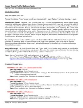
2002.1.2
·
Series
·
1900-1939
Part of Prince George Railway & Forestry Museum Collection
The Grand Trunk Railway and Grand Trunk Pacific Railway series consists of administrative records, correspondence between railways, and ephemera. Also consists of maps and technical drawings depicting Grand Trunk Railway and Grand Trunk Pacific Railway rail lines and structures.
2012.13.2.15.30
·
File
·
[before 1980]
Part of J. Kent Sedgwick fonds
File consists of notes and reproductions relating to the Grand Trunk Pacific Railway in Prince Rupert. Also includes a map depicting the Prince Rupert townsite (before 1980).
2012.13.6.01
·
File
·
[before 2004]
Part of J. Kent Sedgwick fonds
Item is a photocopy of a topographical map published by the Grand Trunk Pacific Railway depicting Fort George and Indian Reserve No.1 and the surrounding area.
2023.7
·
Fonds
·
1943-2015
Fonds consists of material created and collected by wildlife biologist Grant Hazelwood in relation to his work and research regarding wildlife, habitat, and wilderness parks. Includes material regarding Hazelwood's Tailed Frog (Ascaphus truei) research. Also includes records regarding his contracted biologist work via his consultancy business, Alpenglow Resources, on the BC Ministry of Environment's "Upper Nass Assessment Project", a project that included the biophysical mapping of the Northwest-Klappan Road Access Area.
Hazelwood, W. Grant
2020.4.7.017
·
Item
·
1982
Part of G. Gary Runka fonds
2020.4.7.023
·
Item
·
1982
Part of G. Gary Runka fonds
2016.5
·
Fonds
·
1957-2014
Fonds consists of records Harry Coates created or received and retained during his career as a BC Forest Service Research Technician and into his retirement as a Sustainable Forest Management activist. Fonds includes materials from his work at the Aleza Lake Research Forest.
Coates, Harry
2023.5.1.02
·
Item
·
Mar. 1976
Part of UNBC School of Planning and Sustainability fonds
Item is a hand drawn and coloured map by the City of Prince George Planning Department depicting Hart Highway neighbourhood area existing land use in 1976.
City of Prince George
2002.17
·
Collection
·
1912-1914
Collection consists of materials related to Fort George surveying and preemption, including both legal and personal correspondence, legal documents and records, plans of lots, photographs, and a map. Includes records from the Cariboo Investment Company, Ltd., J.B. Henderson-Roe and C.H. Henderson Roe.
2000.23.1.070.11
·
Item
·
[between 1967 and 1987]
Part of Audrey Smedley L'Heureux fonds
The map is part of an advertising pamphlet that depicts the Yellowhead Highway 16. The map highlights towns and tourist attractions along Highway 16 like Hazelton, Kitimat, Vanderhoof, Fraser Lake, Burns Lake, Fort St. James, Prince George, Terrace, and Smithers.
2009.6.13.45.22
·
Item
·
[between 1974 - 1979]
Part of The Honourable Iona Campagnolo fonds
Map depicts Western Canada and annotations highlight the prospective members and the member centres of the Yellowhead Interprovincial Highway Association.
2013.6.35.10
·
Item
·
Mar. 1992
Part of David Davies Railway Collection
Map depicts historical rail lines in the BC lower mainland, including trackage for the BC Electric Railway, the Canadian Northern Pacific Railway, the Canadian Pacific Railway, the Great Northern Railway, and the Pacific Great Eastern Railway, among others.