2020.4.6.021.07
·
Item
·
Sept. 1979
Part of G. Gary Runka fonds
21337 results with digital objects
Show results with digital objects
2020.4.6.021.03
·
Item
·
Sept. 1979
Part of G. Gary Runka fonds
2000.11.2.48
·
Item
·
Jul-82
Part of Mary Fallis fonds
Frontal detail of Rosa in flower

2007.1.45.49.15
·
Item
·
20 Aug. 1957
Part of Aleza Lake Research Forest fonds
Logging plan of Sinclair Spruce Lumber Company's T.S.X. 73378 at Hubble Creek shows areas to be cut. Annotations show areas logged.

2007.1.45.49.14
·
Item
·
20 Aug. 1957
Part of Aleza Lake Research Forest fonds
Logging plan of Sinclair Spruce Lumber Company's T.S.X. 73378 at Hubble Creek shows areas to be cut.

2006.18.5.17
·
Item
·
18 May 1971
Part of Aleza Lake Research Forest Society fonds
Map reproduction of the Sinclair Spruce Lumber Co. Ltd. T.S.H.L. A01848 C.P. 310 cutting area, likely in the Aleza Lake Research Forest.

2012.13.1.87.014
·
Item
·
[between 1975 and 1995]
Part of J. Kent Sedgwick fonds
Image depicts railway tracks and buildings with a beehive burner on the left. The location is likely Sinclair Mills, B.C. Map coordinates 54°01'17.4"N 121°40'53.0"W
2012.13.2.17.15.3
·
Item
·
2010
Part of J. Kent Sedgwick fonds
The item is a photograph depicting a pit along the North Road camp for Sinclair Mills. Annotation on reverse side of photograph states, "N Road pit."
2012.13.2.17.15.1
·
Item
·
2010
Part of J. Kent Sedgwick fonds
The item is a photograph depicting North Road camp for Sinclair Mills looking North. Annotation on reverse side of photograph states, "North Rd camp 2010, looking N."
2012.13.2.17.15.2
·
Item
·
2010
Part of J. Kent Sedgwick fonds
The item is a photograph depicting North Road camp for Sinclair Mills looking South. Annotation on reverse side of photograph states, "North Rd camp 2010, looking S."
2012.13.1.135.5.06
·
Item
·
2010
Part of J. Kent Sedgwick fonds
Photograph depicts the Sinclair Mills community hall, it includes a sign in front of the building reading "Welcome to Sinclair Mills, Community Hall".
2012.13.2.17.06.6
·
Item
·
[between 1999 and 2005]
Part of J. Kent Sedgwick fonds
The item is a photograph depicting the Sinclair Mill's bunkhouse. Annotation on reverse side of the photograph states, "Sinclair Mill's Bunkhouse."

2012.13.1.87.005
·
Item
·
[between 1975 and 1995]
Part of J. Kent Sedgwick fonds
Image depicts a beehive burner covered in snow in Sinclair Mills, B.C. Map coordinates 54°01'17.4"N 121°40'53.0"W
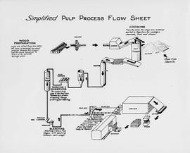
2012.05.01.01.02
·
Item
·
[ca. 1967]
Part of Columbia Cellulose Company, Ltd. fonds
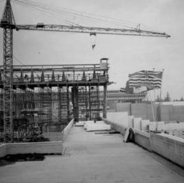
2013.6.36.1.003.076
·
Item
·
Sept. 1965
Part of David Davies Railway Collection
Photograph depicts Simon Fraser University in Burnaby, B.C., 1 week after the official opening.
2013.6.36.1.003.079
·
Item
·
Sept. 1965
Part of David Davies Railway Collection
Photograph depicts Simon Fraser University in Burnaby, B.C., one week after the official opening.
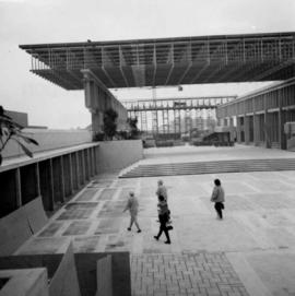
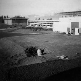
2013.6.36.1.003.078
·
Item
·
Nov. 1965
Part of David Davies Railway Collection
Photograph depicts Simon Fraser University in Burnaby, B.C. The view is looking northeast towards the northwest corner of the Academic Quadrangle.
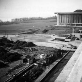
2013.6.36.1.003.080
·
Item
·
Nov. 1965
Part of David Davies Railway Collection
Photograph depicts Simon Fraser University in Burnaby, B.C. The view is looking northwest from the science complex towards the gymnasium.
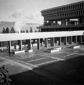
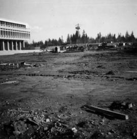
2013.6.36.1.003.077
·
Item
·
Nov. 1965
Part of David Davies Railway Collection
Photograph depicts Simon Fraser University in Burnaby, B.C. The view is looking southwest from the mall towards the gym and sports arena.
2013.6.36.1.003.081
·
Item
·
Nov. 1965
Part of David Davies Railway Collection
Photograph depicts Simon Fraser University in Burnaby, B.C. The view is looking east towards the nearly completed water tower from the west inner face of the Academic Quadrangle.
1994.1.1.5.6.05
·
Item
·
[May 1995]
Part of UNBC Office of External Relations
Video is a recording of Simon Fraser University graduation in 1995. Includes footage of UNBC Chancellor Iona Campagnolo receiving an honourary degree from SFU.
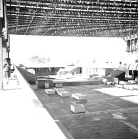
2013.6.36.1.088.15
·
Item
·
Jan. 1966
Part of David Davies Railway Collection
Photograph depicts "The Mall" at Simon Fraser University.
2020.4.2.3.063
·
Item
·
[1986?]
Part of G. Gary Runka fonds
Item is a copy of "Silviculture - a site degradation consideration?".
Item
·
May-80
Part of Mary Fallis fonds
Item
·
4/1/1977
Part of Mary Fallis fonds
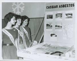
2000.1.1.4.4.1
·
Item
·
1963
Part of Cassiar Asbestos Corporation Ltd. fonds
Photograph depicts three young women wearing "PRINCESS SILVER STAR" banners, standing to left of "CASSIAR ASBESTOS CORPORATION LTD" display table. Table features photos, rock samples possibly containing asbestos, and objects presumably made from asbestos fibre. Large snowflake symbol visible on wall in background. Photo speculated to have been taken at an event in Vernon, B.C. Handwritten annotation on verso of photograph: "1963".
Item
·
May-76
Part of Mary Fallis fonds
Detail of silver catkins
Item
·
1/1/1979
Part of Mary Fallis fonds
<i>Populus deltoides</i> in snowy landscape, Prince George, British Columbia
2023.2.2.8.12.29
·
Item
·
2003
Part of Dr. Paul Sanborn fonds
2023.2.2.8.12.30
·
Item
·
2003
Part of Dr. Paul Sanborn fonds
2023.2.2.8.12.27
·
Item
·
2003
Part of Dr. Paul Sanborn fonds
2023.2.2.8.12.28
·
Item
·
2003
Part of Dr. Paul Sanborn fonds
2023.2.2.8.12.26
·
Item
·
2003
Part of Dr. Paul Sanborn fonds
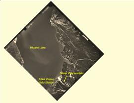
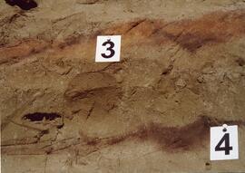
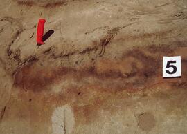
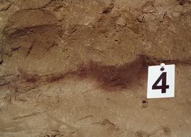
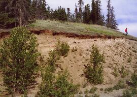
2023.2.2.8.03
·
Item
·
[2004?]
Part of Dr. Paul Sanborn fonds
This PDF contains site location data and annotated soil profile photographs for soil charcoal samples at the Silver City section (site Y03-11).

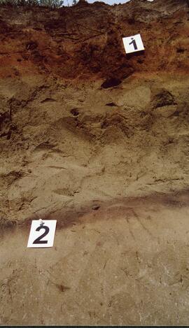
2012.13.1.124.25
·
Item
·
1977
Part of J. Kent Sedgwick fonds
Image depicts layers of silt along the Chilako River near Blackwater Road, Prince George, B.C.
2012.13.2.17.19.01
·
Item
·
Oct. 2005
Part of J. Kent Sedgwick fonds
The item is a photograph depicting two silos at the Salmon Valley Ranch. Various cattle buildings are in the background.
2012.13.2.17.19.14
·
Item
·
Mar. 2007
Part of J. Kent Sedgwick fonds
The item is a photograph depicting two silos at the Salmon Valley Ranch. Various cattle buildings are in the background.
2012.13.2.17.19.16
·
Item
·
Mar. 2007
Part of J. Kent Sedgwick fonds
The item is a photograph depicting the interior of a silo at the Salmon Valley Ranch. The silo is in disrepair and there are many holes in the ceiling.
2012.13.2.17.19.17
·
Item
·
Mar. 2007
Part of J. Kent Sedgwick fonds
The item is a photograph depicting the interior of a silo at the Salmon Valley Ranch. The silo is in disrepair and there are many holes in the ceiling.
2012.13.2.17.19.15
·
Item
·
Mar. 2007
Part of J. Kent Sedgwick fonds
The item is a photograph depicting a silo at the Salmon Valley Ranch.
1996.8.1.092
·
Item
Part of Chander Suri fonds
A tracing paper which represents the title "Sikh Tample"
1996.8.1.111
·
Item
Part of Chander Suri fonds
One letter dated 4 May 1977 from Guru Nanak Cultural Assn. addressed to Mr. C. Suri re. Sikh temple. One page of handwritten personal notes. Two pages documents re "Certificate of Indefeasible Title " from 1975. A photocopy of a plan re city subdivision of roads and residential/non-residential areas.
1996.8.1.093
·
Item
Part of Chander Suri fonds
A b&w plan drafted on a tracing paper, shows South and East Elevations of the Sikh temple in Prince George.
1996.8.1.094
·
Item
Part of Chander Suri fonds
A b&w plan drafted on a tracing paper, shows North and West Elevations of the Sikh temple in Prince George.
1996.8.1.095
·
Item
Part of Chander Suri fonds
A b&w plan drafted on a tracing paper, shows the footing plan of the Sikh temple in Prince George.
1996.8.1.097
·
Item
Part of Chander Suri fonds
A b&w plan drafted on a tracing paper, shows section, left and front Elevations of the Sikh temple in Prince George.
1996.8.1.098
·
Item
Part of Chander Suri fonds
A b&w plan drafted on a tracing paper, showing the ground floor plan of the Sikh temple in Prince George.
1996.8.1.100
·
Item
Part of Chander Suri fonds
A b&w plan drafted on a tracing paper, showing the basement plan and the main floor plan of the Sikh temple in Prince George.
1996.8.1.107
·
Item
Part of Chander Suri fonds
A colour plan drafted on a tracing paper, showing the site plan of the Sikh temple in Prince George. Spruceland Shopping Centre, 5th Ave and Kelly Road are identified on the plan.
1996.8.1.101
·
Item
Part of Chander Suri fonds
A colour plan drafted on a tracing paper, showing the main floor plan of the Sikh temple in Prince George.