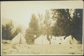
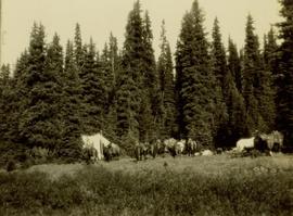
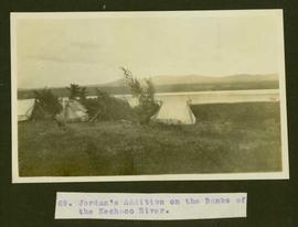
Typed caption glued to album page directly below photograph reads: "69. Jordan's Addition on the Banks of the Nechac[k]o River." Photograph depicts three tents situated in an open field near the Nechako River. Photographer: Dominion Stock & Bond Corporation.
Photograph depicts four tents with laundry line hung between them, trees and hills in background. Handwritten annotation on recto of photograph: "The Camp."
Image depicts several orange and blue tents, possibly somewhere near Riske Creek, B.C.
File contains a personal journal entitled "Tenth Journal ". Journal entries dated July 18, 1970.
A b&w subdivision plan.
Chief Lake Road is identified on the plan.
The plan includes lots, Chief Lake Road and elevation information.
A b&w plan drafted on a tracing paper. Chief Lake Road is identified on the plan.
A b&w plan drafted on tracing paper, illustrating subdivision of lots. Domagala Road is identified on the plan.
A b&w (photocopy) of a plan illustrating subdivision of a region. Croft Road and Hepting Road are identified on the plan.
Photo description on accompanying photo album page: " 'Yonge Street' at Teslin Lake, Yukon. The centre tent was used by the radio men. Teslin, 130 miles south of Whitehorse, is the site of one of the aircraft radio stations on the new Edmonton-Whitehorse circuit, paralleling the Alaska Highway."
Photograph depicts tent structures in the early construction camp at Cassiar. Snow-covered area in foreground, trees in background.
Photograph depicts tent structures among trees at the temporary Cassiar construction camp. Taken from future site of garage building, looking northwest, snow-capped mountain in background.
Gathering of tents in Vickersville with the harbour and mountains in the distance. Annotation on recto reads: "Vickersville Prince Rupert o/n[?] 1908."
Photograph depicts a tent camp with lumber and steel drums nearby. A mountain is in the background.
Item is a photograph of a copy print, resulting in a low quality photographic reproduction. Reproduced as a print, slide, and a negative. Location of original photograph is unknown.
Photograph depicts a tennis court in Mirror Lake Inn, NY. Trip is possibly in relation to the 1980 Winter Olympics in Lake Placid, NY.
Item is an original copy of "Ten Years of Agricultural Land Preservation" the 1983 anniversary publication by the Provincial Agricultural Land Commission.
The group stands in front of an ornate stone wall and two Canadian flags.
Handwritten annotation on photograph enclosure reads: “8/6/99. Dear Lady, When I saw this photograph I knew there was a certain person who would truly appreciate and ‘feel’ its significance. Not many steps left to take now . . . . your unwavering support is never more appreciated. best personal regards, Peter”; handwritten annotation on verso reads: “Nisga’a”.
Annotation on recto: "I-57373" which denotes the same photograph in the collection of the BC Archives.
Stamped annotation on verso: "Printed by Leffler"
Photograph depicts ten ballast cars of the B.C. Electric Railway on newly laid industrial spur on the northeast side of the Langley depot.
Part of a set of 41 original black & white photographs [1908-1933-?]) of the Grand Trunk Pacific Railway line in BC depicting surveying crews, town sites (Prince Rupert and its port, Hazelton and Fort George), and First Nations Peoples.
Image depicts the Royal Bank of Canada in Telkwa, B.C.
Image depicts a view of a lake that is near Telkwa, B.C. The slide is labelled as "Telkwa - McClure Lake," though it is possibly Tyhee Lake.
Image depicts two bridges in Telkwa, B.C. One is for trains.
Image depicts a street in Telkwa, B.C.
Image depicts the Telkwa river in Telkwa, B.C.
Television sits on small table on deck outdoors.
Handwritten annotation on verso reads: “First Show for CBC-T.V., August 1979, VCR.”
Photograph depicts a telephone pole near Reiswig, on the main road between Vernon and Arrow Lakes.
Photograph depicts telephone fittings on Vancouver Island.
Image depicts a man with the wire for the telegraph trail in an uncertain location.
Image depicts the old telegraph station in Stewart, B.C.
Image depicts a field along Telegraph Road, south-west of Vanderhoof, B.C.
Image depicts Telegraph Road, south-west of Vanderhoof, B.C.
Photograph depicts a telegraph line on the Williams Lake to Bella Coola road.
Image depicts the Telegraph Creek Road, as well as the Creek itself.
Image depicts Telegraph Creek Road.
Image depicts the Telegraph Creek.