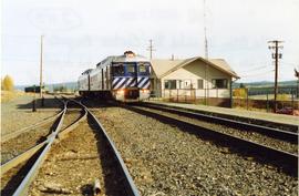
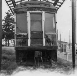
Photograph depicts car #1223 on display in south Burnaby beside the RCMP headquarters in Kingsway and Edmonds St., on site of the former track. It is covered but in poor shape.
Photograph depicts a car at the Revelstoke yards. It was built in 1948 for newsprint only and painted green
Image depicts a car on a dirt road leading through a forest.
Photograph depicts car on water's edge at bottom of incline, possibly damaged, with back doors open. Trees and bushes in foreground.
Photograph depicts a car parked on Hurricane Ridge in Olympic National Park, south of Port Angeles, Washington.
Habitat of caramel coloured mushroom, moss, cloudberry [Rubus chamaemorus] and Ledum leaves
Annotation on recto: "I-33249" which denotes the same photograph in the collection of the BC Archives. Annotation on recto: "Heavy going on soft ground".
Image depicts Bennett Lake near Carcross, Y.T.
Image depicts the train station in Carcross, Y.T.
Card consists of a photograph of (presumably) M.S. Hornby and reads: "The Hornby Farms, Lethbridge, Alberta, Canada, 1944: Best wishes Harry to you & your wife & family for 1945. Yrs M.S. Hornby".
Photograph taken at terrace gardens, Government House in Victoria, B.C.
Image depicts a log house at an uncertain location; the slide is simply labelled "Cariboo."
A colour plan drafted on a tracing paper illustrating roads and subdivisions of the surrounding areas near Princ George. Mossvile Road is identified on the plan. Produced by Central Planning and Management Consulting LTD.
A blueprint of a plan re subdivision of Cariboo district. Produced by McWilliam, Whyte, Goble, and Associates, B.C. Land Surveyors Prince George - Kamloops - Smithers. Ospika Boulevard, Pinewood Ave, Massey Ave and etc. are identified on the plan.
Five b&w copies of a plan re Plan of Subdivision of Part of Rem. Parcel B (C5411) of District Lot 71, Cariboo District. Produced by McWilliam-Wyte-Goble and Associates British Columbia Land Surveyors Kamloops-Prince George-Smithers-Salmon Arm-Clearwater. MacKenzie Ave., Rose Street and 2nd Ave are identified on the plans.
A b&w subdivision plan of Cariboo District. NESS Lake Road is identifed on the plan. It includes legend.
A b&w plan re subdivision of part of Lot 1, plan 23398. District lot 4028. Northwesterly 156.73 Acres of District Lot 4028 Cariboo District - British Columbia.
Two b&w compatible subdivision plans which illustrate a region in Cariboo district. Chief Lake Road is identified on the plan.
A blueprint proposed Plan of Subdivision of REM. Lot A, Plan 17100, D.L.8174, Cariboo District. Produced by McWilliam, Whyte, Goble, and Associates, BC Land Surveyors Prince George - Kamloops - Smithers. Pinewood Ave, Ospika Boulevard, Dufferin Ave are identifed on the plan. It illustrates blocks, lots and subdivision of lands.
A b&w (photocopy) plan of Subdivision of The Remainder of West 1/2 D.L.2413, Cariboo Districtis, produced by McWilliam, Whyte, Goble, and Associates, B.C. Land Surveyors. Prince George - Kamloops - Smithers.
A Plan of Subdivision of The Remainder of West 1/2 D.L.2413, Cariboo District, produced by McWilliam, Whyte, Goble, and Associates, B.C. Land Surveyors. Prince George - Kamloops - Smithers. This plan shows division of lots and roads.
A plan of Right-of-Way in Lot 26, D.L. 2413, Cariboo District. This plan is produced by McWilliam, Whyte, Gobie, and Associates, B.C. Land Surveyors, Prince George - Kamloops - Smithers. This plan lies within the Fraser Fort George Regional District.
A b&w plan of Right of Way (Easement) in Lots 1 to 4, Lot 6 and Lots 8 to 27. D.L. 2413 Cariboo District, produced by McWilliam-Whyte-Goble and Associates B.C. Land Surveyors Prince George-Kamloops-Smithers. The plan shows division of lots and roads.
Plan of Subdivision of the Remainder of West 1/2 D.L. 2413, Cariboo District. This plan is produced by McWilliam, Whyte, Goble, and Associates, B.C. Land Surveyors Prince George - Kamloops - Smithers. The plan lies within the Fraser Fort George Regional District. This plan shows division of lots and roads.
4 b&w plans on two of which are drafted on tracing papers. Illustrating Proposed Subdivision of D.L. 4228 Cariboo Dist. Except Parcel-A and Plan - 4881 C.D.Produced by Central Planning and Management Counsulting LTD.
North is noted on each tracing.
b&w plan re Proposed Subdivision of D.L. 4228 Cariboo Dist. produced by Central Planning and Management Consulting LTD. The plan illustrates subdivision of areas by the West Lake. Lake Shore Res. II and Lake Shore Res. IV. are identified on the map.
A blueprint plan of a region in Cariboo district. Giscome Road, Hedlund Road are identified on the plan. Plan of Subdivision of Lot 1. Plan 16115 District Lot 636 Cariboo District, British Columbia
A blueprint plan re Tentative Plan of Proposed Subdivision of Blocks A and B District Lot 8501 Cariboo District-B.C. Yellowhead Highway, Bednesti Lake and Tamarac Lake are identified on the plan. Plan is produced by W.D. Usher and Associates Land Surveyors Prince George BC.
A b&w plan re Land Use: Highway Commercial Part of SW1/4 of DL 2185 Cariboo District and Proposed Development Plan. Produced by Central Planning and Management Consulting LTD. Prince George, B.C.
The plan shows Old Highway -16E, Yellowhead Highway-16E and other residential and commercial areas.
3 b&w plans re Land Use: Highway Commercial Part of SW1/4 of D.L. 2185 Cariboo District. Illustrate Yellowhead Highway 16E, Old Highway - 16E, and commercial buildings.Plans are produced by Central Planningand Management Consulting LTD. Prince George, BC Canada.
2 compatible b&w subdivision plans re Tentative Plan of Subdivision of D.L. 8379 and D.L. 8380 Except Block-A C.D. Cariboo Dist. Shelly Road is identified on the plans.
A b&w plan drafted on tracing paper, produced by Central Planning and Management Consulting LTD. Plan of Subdivision of D.L.2168 C.D. to Separate Area Outside Agriculture Land Reserve. Six Mile Lake Road is identified on the plan.
Two b&w subdivision plans drafted on tracing paper produced by Central Planning and Management Consulting LTD.
A b&w plan illustrating Plan to Accompany Regional District Zoning By Law NO. 399. Cariboo District. Produced by McWilliam-Whyte-Goble and Associates BC Land Surveyors. Prince George-Kamloops-Smithers.
This plan lies within the Fraser Fort George Regional District.
A b&w plan produced by McWilliam, Whyte, Goble and Associates, BC Land Surveyors, Prince George BC. Elevations and contours from Provice of BC Controur Map.
A b&w plan drafted on tracing paper, produced by Central Planning and Management Consulting LTD. Six Mile Lake Road is identified on the plan.
The map depicts multiple real-estate listings by Multiple Listing Service (MLS) Prince George members.
Image depicts the Cariboo Falls.
Item is a draft of "Cariboo Forest Region Resource Inventory Database".
Photograph depicts a Cariboo Freight Wagon exhibited at Cache Creek, BCThe owner is H.Collins from Cache Creek.
File contains a monthly recording of the wages and expenses of employees from May 1898 to October 1901.
Contains accounts of the Cariboo Hydraulic Mining Company, Ltd. from 1894 to 1896 including bills payable, bank deposits, loans made to mine employees and other financial matters.
Image depicts the Cariboo Lake, with the roof of an old log cabin visible.
Nunavut
Photograph depicts a train called the "Cariboo Prospector." It was supposed to arrive to the station earlier, but a freight locomotive failed north of Williams Lake and blocked the line.