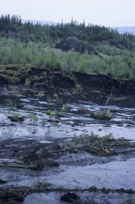
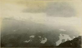
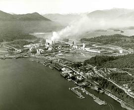
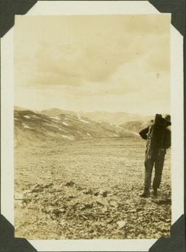
Item is a photograph of a survey crewman, with pack on his back, standing in a tundra-like landscape.
No annotation provided on slide.
Annotation on slide: "Summit Lake, Light Abrasion".
Handwritten photo album caption beside this photo reads: "S/L. A.C. Heaven. C.D. #3 Unit, N.W.S.R. Fort Nelson." Photograph depicts man in uniform standing on steps in front of doorway to unidentified building. Wings medallion on left breast.
Royal Canadian Air ForcePhotograph of the bay at dusk. Trees and distant machinery are silhouetted against a cloudy sky and dark waterfront. Annotation on recto reads: "Across the Bay, Prince Rupert, BC No 4466."
Photograph depicts four women seated on fallen log in wood clearing, watching two men and one woman who have their back turned to the camera. It is speculated that Violet Baxter may be seated on right.
Four unidentified women and one unidentified man pose in costume in front of theatre sets. Play produced and directed by Iona Campagnolo.
Photo description on accompanying photo album page: "The bungalow-like Administration Building under construction at Teslin Lake, Yukon Territory. The top portion will be the control tower."
Annotation on slide: "BC[?] advance regen. releasing in logged cedar block, ICHwk3"
Photograph taken at the Mudbay Light Aircraft Airfield in Delta. Visible is an advanced trainer called the "North American (Aviation Co.) Texan" that was of the USA and Harvard in Britain and Canada. Some were built in Canada during WWII.
Photograph shows an aerial view of Aleza Lake Research Forest in spring season.
Air photograph depicts a segment of the West Coast Trail showing the beach area around the Carmanah Point Light Station. Coding on aerial is "BCO 391".
Air photograph depicts a segment of the West Coast Trail showing the beach area around the cabins at Nitinat Narrows. Coding on aerial is "BCO 390".
Air photograph depicts a segment of the West Coast Trail showing the beach area around Tsusiat Falls. Coding on aerial is "BCO 387".
Air photograph depicts a segment of the West Coast Trail showing the beach area around Tsusiat Falls. Coding on aerial is "BCO 388".
Air photograph depicts a segment of the West Coast Trail showing the beach area around Tsusiat Point Hole in the Wall. Coding on aerial is "BCO 389".
Photograph depicts a northwest aerial view from Sustut River of a snow-covered mountain range toward Thutade Lake.
Photograph depicts a northwest aerial view from Sustut Pass of a snow-covered mountain range toward Thutade Lake.
Photograph depicts an aerial view of a city, possibly Berlin, in East Germany. The photograph was taken on Iona Campagnolo's European sports tour.
Photograph is one of seven images believed to have been taken on a Canadian University Service Overseas (CUSO) mission in Mozambique; see also items 2009.6.1.483 - 2009.6.1.489.
Photograph depicts the asbestos warehouse and warf in proximity to a residential area.
Photograph depicts an aerial view of the asbestos warf from the rear, looking towards the harbour.
Photograph depicts the asbestos wharf with a large residential area immediately behind.
Attached description: This aerial view of the chip distribution system shows the network of enclosed conveyors which distribute different species of chips to individual piles. Reclaim-pits under these piles pick up chips for transporting to the two Kamyr continuous digesters. The building in the lower right of the picture is the main structure, housing the transfers and screening with the operators on the top floor. A blower system is used to carry chips from the existing Woodroom No. 1 to the piles. In the background, the sulphite and kraft pulping groups of Columbia Cellulose and Skeena Kraft are shown.
Photograph depicts an aerial view of the Clinton Creek area.
Photograph depicts an aerial view of the Clinton Creek mine.
Photograph depicts an aerial view of the Clinton Creek plantsite.
Photograph depicts an aerial view of the Clinton Creek mine quarry site.
Photograph depicts an aerial view of the Clinton Creek quarry site on the mountain.
Photograph depicts an aerial view of the Clinton Creek residential area with autumn colours.
Photograph depicts an aerial view of the Clinton Creek townsite.
Attached description: Both the Columbia Cellulose Sulphite mill and the Skeena Kraft mill are shown in this aerial view. Woodroom No. 2 is shown at the left, and the main buildings of the sulphite mill in center. The right centre area of the picture shows the new 750 t/d Skeena Kraft mill. Skeena Kraft is the largest single-line pulp mill in operation in the world. In the foreground is the fishing village of Port Edward. The Integration of chip manufacturing and power plants provides the mills with common service facilities. Watson Island is approximately 11 miles from the city of Prince Rupert, which now has a population of about 17,000 people.
Photograph depicts an aerial view of the Fairview container terminal in Prince Rupert
Photograph depicts an aerial view of Finlay Falls from below Thutade Lake set in a forested landscape.
No annotation on slide.
Item is a photograph of forests and farms from the air.
Photograph depicts an aerial view of the Haida Gwaii shoreline near Kiusta.
Photograph depicts steel drums and wooden buildings at an exploration camp in the Kutcho Creek valley area of B.C. The camp was set up by a crew led by Cassiar's Chief Geologist Bill Plumb. An arrow points to a possible burial site.
Photograph depicts steel drums and wooden buildings at an exploration camp in the Kutcho Creek valley area of B.C. The camp was set up by a crew led by Cassiar's Chief Geologist Bill Plumb.
Image depicts an aerial view of the land in the area of Divide Lake.