Item is a photocopied map of the Aleza Lake area annotated to show transects.
Item is a reproduced map of Aleza Lake annotated to show a 1994 RFP study area.
Item is a map annotated in colour by the City of Prince George Planning Department depicting major residential development proposals from June 1975 to August 1977 in the City of Prince George. This map was drawn for the City of Prince George interim Community Plan.
Map depicts the whole of Canada and notes: gas pipelines, gas gathering lines, proposed gas pipelines, oil pipelines, oil gathering lines, proposed oil pipelines, gas fields, oil fields, refining centres, extraction plants, and oil sands. There is a smaller subsequent map of Alberta highlighting these features in greater detail.
Area covered: Howe Sound to Maple Ridge/Langley / Coquitlam Lake to international boundary.
Shows: lost streams & shores; existing streams & shores; existing freshwater bodies of water; roads; municipalities.
Verso: Stewarding our local streams; Stream stories; text; illustrations.
Contemporary stream information from TRIM program.
Map depicts producing mines and prospects in British Columbia and parts of Alberta.
Map depicts locations of all mining properties in British Columbia. Includes index with names of owners of properties.
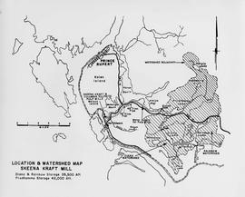
Item is a map showing the watersheds of Diana Lake, Rainbow Lake and Prudhomme Lake.
Map depicts the Kitlope range, Kimsquit Watershed, and area around Kitlope Lake. Includes Indigenous place names, grease trails, Indigenous village sites, and wildlife information.
The map depicts the town of Kitimat and on the other side of the map there is an advertisement for Northland Shipping.
Map depicts the city of Kelowna and area. Annotated by Davies to emphasize rail lines.
Map depicts area around Kelowna, with annotated Kettle Valley Railway Carmi subdivision line, Hydraulic Lake, and McCulloch.
The item is a map depicting the area surrounding the Hixon area in the Cariboo District. There are various annotations in pen and highlighted boundaries.
Map depicts historical rail lines in the BC lower mainland, including trackage for the BC Electric Railway, the Canadian Northern Pacific Railway, the Canadian Pacific Railway, the Great Northern Railway, and the Pacific Great Eastern Railway, among others.
Map depicts Western Canada and annotations highlight the prospective members and the member centres of the Yellowhead Interprovincial Highway Association.
The map is part of an advertising pamphlet that depicts the Yellowhead Highway 16. The map highlights towns and tourist attractions along Highway 16 like Hazelton, Kitimat, Vanderhoof, Fraser Lake, Burns Lake, Fort St. James, Prince George, Terrace, and Smithers.
Item is a hand drawn and coloured map by the City of Prince George Planning Department depicting Hart Highway neighbourhood area existing land use in 1976.
City of Prince GeorgeMap reflects soil and landforms of Giscome area.
Item is a reproduction of a draft "Fort Nelson Land and Resource Management Plan", accompanied by an original 1997 "Fort Nelson L.R.M.P. Plan Area" map produced by BC Ministry of Forests for the Fort Nelson LRMP Working Group.
The item is a reproduction of a survey map drafted on 20 Nov. 1910. The reproduction was likely created in 1990. The subdivision is lot 2610 G. I. and part of lots 2507 and 2608 G. I. Cariboo District. The area covered is South of 8th Avenue, East of 19th Avenue, North of 8th Street and West of Quinn Street. Annotations state, "Pl. 847," and various notations regarding lot information.
Colour-coded topographic map depicts forest stands of different heights.
Original forest cover map shows timber history in the area of Giscome, BC.
Item is a Forest Cover Map, 93J-7, annotation on the back reads Summit Lake. Geographical features include Summit Lake and Crooked River.
Item is a Forest Cover Map, 93J-10-d, annotation on the back reads Carpet Lake. Geographic features include Merton Lake and Peculiar Lake.
The item is a reproduction of a survey map drafted in January 1910. The reproduction was likely created in 1990. The subdivision is Lot 936 G. I. Cariboo District, B.C. The area covered is North of Twenty First Avenue, East of Quinn Street, South of Eighth Avenue and West of Carney Street. Annotations highlight "Owner Edgar McMickiny," "696" and "Jordan Brothel" written in red pen pointing to a specific location.
Map depicts Bee Peak, Golden Mountain, Mount Fetterly, Mount Brook, Ear Mountain, Sunday Peak, Graham Inlet, and Taku Arm of Tagish Lake.
Map shows project boundaries in Mont Ste. Marie for proposed sports training centre at a ski resort.
Map includes an annotated line indicating the city limits and the crown land surrounding the village of Kitimat.
The map depicts the distribution locations and transportation routes for the processing of mineral and petroleum in British Columbia.
Map of Timber Sale X72108 shows area to be scarified, as well as previously logged areas. Location is outside Prince George in the Upper Fraser area near Kenneth Creek.
Map of Timber Sale X72108 shows area to be scarified. Location is outside Prince George in the Upper Fraser area near Kenneth Creek.
Map of Timber Sale X72108 shows area to be scarified. Location is outside Prince George in the Upper Fraser area near Kenneth Creek.
Item is a map of Prince George Wood Preserving Ltd. Development Plan Forest Licence A27771 for the period of January 1, 1986 to January 1, 1991: Fraser Operating Area. Geographic features include the Fraser River.
The item is a map depicting the Crooked River Provincial Forest area. Sections of the map are highlighted and coordinates are annotated in ink.
Map reflects highways, main, branch and property roads, trails, public sustained yield unit boundaries, cutting permit boundary, contours, height of land, edge of lake, merchantable and immature timber, non-commercial cover, and swamps.
Map depicts the Cowichan Lake area, including rail trackage for the Western Forest Industries Logging Railway, the Canadian National Railway, and the BC Forest Products Logging Railway.
Map depicts the Cowichan Lake area, including rail trackage for the Western Forest Industries Logging Railway, the Canadian National Railway, and the BC Forest Products Logging Railway.


