File consists of advertising brochures for Southridge, McGill Crescent, The Courtyard on sixth avenue, and property listings. Includes developments in Vancouver.
The Prince George Railway & Forestry Museum Society Collection consists primarily of textual, photographic, and cartographic records related to the regional developments of the railway industry in Northern BC. A predominant portion of the collection is made up of material from the Canadian National Railway; other railways represented include the Pacific Great Eastern Railway, the British Columbia Railway (BC Rail), the Grand Trunk Pacific Railway, the Grand Trunk Railway, the Intercolonial Railway, and the Okanagan Express. Significant geographical areas covered include Prince George, the Peace River Region, Terrace, Bulkley Valley, Hazelton and Prince Rupert.
The forestry industry is represented in the collection with operational and financial records from Fyfe Lake Sawmill Ltd., which operated southwest of Prince George in the 1950s.
The collection has been organized into series according to creator, each of which also has been arranged to subseries, file and item level, where applicable. This collection consists of eight series, as follows:
1) Canadian National Railway
2) Grand Trunk Railway
3) Pacific Great Eastern Railway
4) British Columbia Railway (BC Rail)
5) Canadian Pacific Railway (CPR)
6) Intercolonial Railway
7) Fyfe Lake Sawmill ltd.
8) PGRFM
9) Photographs
File consists of appraisals, indentures, and surveys of properties in the Prince George area. Includes two photographs taken at Fraser Lake.
File consists of numerous property listings within the Prince George area.
File consists of multiple documents regarding properties in Prince George including lot maps, the establishment of a McDonald's restaurant, an Emerald Estates booklet, correspondence, and newspaper photocopies. Prepared by multiple companies including McDonald's Restuarants of Canada Ltd, W.D. Usher & Associates, and North Central Management Corporation.
File consists of population data from the Regional District of Fraser-Fort George.
File consists of documents relating to the Prince George Pentecostal's property search. Includes meeting minutes, overhead transparencies, resolutions, correspondence, brochures, a proposal for Westside Academy, a BC Housing information booklet, newspaper clippings, handwritten notes, and reports.
Subseries includes research material created and collected by Kent Sedgwick relating to land survey, development, and settlement in Prince George and British Columbia. Land surveys were conducted in British Columbia by surveyors George Dawson, the North Coast Land Company, Alfred R.C. Selwyn, and the Geological Survey of Canada during the late 19th and early 20th centuries. James C. Anderson and engineer J. Gill conducted topographical surveys for the Grand Trunk Pacific Railway on Fort George and the Indian Reserve. Surveyors and land plot companies developed the land for sale to promote settlement in the area. Also includes materials regarding the continued development of the City of Prince George throughout the 20th century. The files primarily consist of newspaper clippings, research notes, and photocopied documents.
File consists of spreadsheets detailing the distribution of established timber sale in the Prince George Forest District. Includes a tree farm license map of the district.
This fold out brochure, published by the Prince George Board of Trade, provides an overview of the industries present in Prince George by the BC Centennial; as well as a brief presentation of local recreational opportunities and a mileage listing.
File consists of a brochure package advertising Prince George to investors, prepared by the Prince George Region Development corporation.
Item is an original copy of a 2002 promotional booklet produced by the BC Agricultural Land Commission entitled "Preserving Our Foodlands".
File consists of four presentation speeches from the Pacific Northwest Trade Association Conference concerning industry and the environment in North America.
File consists of notes and clippings relating to a presentation on the Millar Addition by Kent Sedgwick. Also includes "Please join us as we celebrate Heritage Week 2000!" printed invitation (26 Feb. 2000).
File consists of a preliminary economic report by the Regional District of Fraser Fort-George on the communities between McBride and Valemount.
3 duplicate copies available.
This DVD contains a documentary entitled "Power Play: The Theft of BC's Rivers Vol. 1" on the privatization of British Columbia's river and public power. The filmmakers' original website ( www.SaveOurRivers.ca ) can be accessed via the Internet Archive.
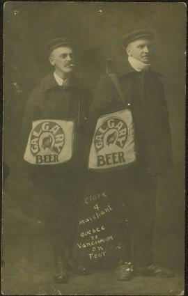
Photograph depicts two men posed with "CALGARY BEER" bags slung over shoulders. Handwritten annotation on verso of photograph: "Clark & Marchant Quebec to Vancouver on Foot", on recto: "To H F Glassey With Every Good wish. from Leo Marchant. Pearson's Magazine 1909."
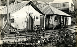
Photograph of post office and neighbouring building. Both buildings are composed of wood and tent materials. Annotation on recto reads: "Post Office & Customs House, Prince Rupert, BC."
File consists of an article written by Gary Runka entitled "Political Realities - Protecting our Dwindling Soil Resource". This was published "Agrologist" magazine (Fall 1980) as "Protecting the soil".
Commentary on this speech by Barry Smith of the Ministry of Agriculture and Lands:
"This paper is focused on the importance of soil conservation. It makes the observation that soil erosion is often not recognized until the damage has been done, but it takes even longer for politicians to be aware of the problem and then for this to translate into policy change. It is noted that this is especially a problem given the short term time horizons of politicians. There is a discussion of what jurisdiction is best to deal with protecting the soil resource. It is emphasized that we no longer have the luxury of time."
File consists of policy plan regional settlement pattern questionaire designed around the Central Interior of BC. Includes a survey questionaire for planning practitioners across Canada.
Item is a summary of Alastair McLean's thesis entitled "Plant Communities of the Similkameen Valley, British Columbia and their Relationships to Soils".
Consists of legal records and documents related to the holdings and activities of J. B. Henderson-Roe and his father, C.H. Henderson-Roe, including a hand-drawn map of Prince George, Fort George, and South Fort George, as well as a surveyor's plan for a subdivision.
File consists of a speech given by Gary Runka entitled "Planning for the Future Agricultural Land Base of Alberta" for Alberta Agriculture Land Use Activities, Edmonton, June 2,1981.
Commentary on this speech by Barry Smith of the Ministry of Agriculture and Lands:
"This appears to be a set of preliminary speaking notes - much of it is point form with considerable hand written notes in the margins. It is not known if these notes were ever finalized into the speech given on June 2,1981 or if the speech was simply given using these notes as its basis.
Many of the references are somewhat oblique relating to topical matters in Alberta. While agriculture is the central theme, this speech is focused on Alberta with little or no reference to the BC farmland preservation program.
Several broader themes are considered which are dealt with in other speeches but GGR speaks to the longer term importance of farmland preservation legislation when stating (p. 3):
"b) from my experience, time is demonstrating ever more clearly to me that, for a variety of reasons, legislating land preservation alone can only hold the land resource for so long if the other aspects affecting the food producing industry are not also given attention e.g.:
- review of regional planning by the ARB
- costs of production and marketing opportunities
- gov't priority for ag. related to other prov. resources
- urban planning - where are the cites going?
- rural planning - how secure are the rural communities of which agriculture is a part?"
File consists of a draft copy of an address by J.D. Mawell for delivery at the Sixth Annual Aministrator's Seminar for the BC Hospital's Association. The speech outlines aspirations for the Hospital Association in the future.
Item is an original copy of "Planning for Agriculture - Resource Materials" by Barry E. Smith, Policy Planner for the BC Provincial Agricultural Land Commission.
Item is an original copy of "Planning for Agriculture" by Barry E. Smith, Policy Planner for the BC Provincial Agricultural Land Commission.
File consists of recreation reports, a Knothole zoning by-law article, public hearing agenda, and an industrial land use report, a number of reports on the zoning needs of small surrounding communities, a report on proposed rail routes to the NE of the province, a report on space requirements for downtown Prince George, a proposed study of water supply and sewage requirements in Prince George, a community analysis, statistics and information, presentation speeches on the tourism industry, and a report on the Hospital District in Fraser-Fort George.
File consists of a speech given by Gary Runka to the BC Federation of Labour Environmental Conference entitled "Planned Development and Land Conservation".
Commentary on this speech by Barry Smith of the Ministry of Agriculture and Lands:
"GGR discusses the 'problem' of land being considered as either an "ecological natural resource" or "hot commodity".
He mentions that his background is in the natural sciences and land use planning and prefers to look at land as an ecological resource, not simply as a commodity.
The speech includes a quick review of the Land Commission's work and with reference to the Land Commission Act he makes the following observation (p.2):
"...the purpose is hardly necessary to relate to you - as what animal survives that destroys his food habitat next to his shelter or cover?"
The reason for BC's farmland preservation program could hardly be better stated."
The item is a reproduction of a survey map drafted on 27 July 1910. The reproduction was likely created in 1990. The area covered is South of Reserve Avenue, East of Victoria, North of Bird Avenue and West of 9th Street. Annotations state, "#796" and highlight the date and registered owner.
The item is a reproduction of a survey map drafted on 10 July 1956 and registered on 31 Oct. 1956. The reproduction was likely created in 1990. The plan number is 7782.
The item is a reproduction of a survey map likely drafted in the 1910s. The reproduction was likely created in 1990. The area covered is South of Baillie Street, East of 22nd Avenue, North of Princess Street and West of 7th Avenue. Annotations state, "Pl. 833" and various lot descriptions.
The item is a reproduction of a survey map drafted in 1909. The reproduction was likely created in 1990. The area covered are lots 931 and 417. Annotations state, "Plan 701," and various names are highlighted.
The item is a reproduction of a survey map drafted on 1 March 1910. The reproduction was likely created in 1990. The area highlighted is along the Fraser River. The map details subdivisions East of Ninth Street and South of Thapage Lane. Land Surveyor J. F. Templeton certified the plan. Annotation on the map states, "Pl. 727."
The item is a reproduction of a survey map drafted on 1 March 1910. The reproduction was likely created in 1990. The area covered is South of Bernhardt Avenue, East of Simpson Street, North of the Fraser River and West of 9th Street. Annotations state, "DL 1426 Plan 721."
The item is a reproduction of a survey map drafted in 1 Oct. 1913. The reproduction was likely created in 1990. The area covered is along the Fraser River and west of Linooln Avenue, south of Jackson Street and North of McKinley Street. Annotations state which maps and lots are adjacent to this one. An illegible signature is highlighted.
The item is a reproduction of a survey map drafted on 29 Oct. 1910. The reproduction was likely created in 1990. The area covered is South of Princess Street, East of James Avenue, North of 8th Street and West of Rupert Avenue. Annotations state, "Jesse Hodgeson Crown grand in 1910 for $800..."
The item is a reproduction of a survey map drafted in July 1914. The reproduction was likely created in 1990. The area covered is along the Fraser River and east of Guelph Street. Annotations state, "PL 1409 D. L. 417 HBCo." and highlight different scales of measurement and changed street names.
The item is a reproduction of a survey map likely drafted in the 1910s. The reproduction was likely created in 1990. The area covered is South of Anderson Street, East of Simpson Street, North of Van Bien Avenue and West of 9th Street. Annotations state, "Pl 721 DL 1426."
File consists of financial statements, a lease, and an indenture for Pine Centre Market Inc.
File consists of a plan to develop Pigeon Lake as a provincial park.
File consists of a speech given by Gary Runka entitled "Physical Resource Data Needs in Land Use Planning" which was given at a technical workshop to develop an integrated approach to base data inventories for Canada's Northland.
Commentary on this speech by Barry Smith of the Ministry of Agriculture and Lands:
"While the speech is not related to agriculture or farmland preservation directly, GGR emphasises the importance of data collection and mapping and its use in the planning process. The general principles he discusses were those employed in the development of the Agricultural Land Reserve.
The proceedings of the workshop were published in 1979 by Environment Canada." The proceedings are available online at: https://www.geostrategis.com/PDF/1974-04-17%20remote%20sensing%20for%20northen%20surveys%20and%20environmental%20monitoring-jean%20Thie%20CCRS%20copy.pdf
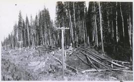
Consists of two photograph albums that illustrate Parker Bonney's early years as a Forest Engineer. Includes photographs of the expedition to the Nass Valley undertaken by Parker Bonney, Sam Brown, and others. May also include photographs of later surveying expeditions.
Photographs consist of 16 black & white photographs depicting Fort George land and surveying, including 3 photographs of Jack Henderson-Roe in front of his log cabin that he constructed in Fort George in 1913.
Gary Runka was a hobbyist photographer and documented his work and personal life through photography as he travelled across every region of British Columbia. His photographs document the evolution of British Columbia communities and regions over a 30 year period. Gary Runka's core interest was land and changing land uses. Many of his photographs tell a story of urban edge and/or natural resource compatibility/conflict. There are also a substantial number of photographs related to soils, including soil profiles, soil erosion and land (topography, drainage etc.) capability for agriculture. The collection also includes specific client-related photos, tied to Land Sense Ltd. client file job numbers.
The collection also documents personal travels and hiking trips throughout British Columbia and backpacking in some historic areas, such as the West Coast Trail and Cape Scott. These photographs also represent land evolution over time, including extent of alpine glaciation or biodiversity/plant species inhabiting the area.
Series consists of photographs of the Island Cache Reunion on June 12-13, 1999.


