Aperçu avant impression Fermer

Affichage de 1372 résultats

Archival description
267 résultats avec objets numériques Afficher les résultats avec des objets numériques
2006.20.3.61 · Pièce · [between 23 May 1906 and 15 October 1906]
Fait partie de Northern BC Archives Historical Photograph Collection

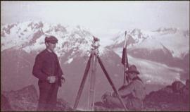
Photograph depicts two men on either side of camera on tripod, flag visible behind them. Mountain range and glacier in background.

Image is one of 65 photos documenting a survey of the Canada-Alaska Boundary, Taku River area, May 23 to Oct. 15, 1906. This particular photo is one of 9 found in original enclosure with the following handwritten annotation: "Pictures of different members of ‘our’ party.” See also items 2006.20.3.57 - 2006.20.3.65.
Taku River Survey - Two Men at Flag
2006.20.3.26 · Pièce · [between 23 May 1906 and 15 October 1906]
Fait partie de Northern BC Archives Historical Photograph Collection

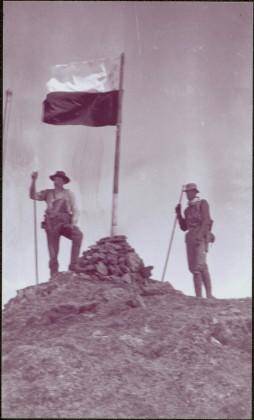
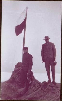
Photograph depicts two unidentified men standing to right of flag mounted in rock pile.

Image is one of 65 photos documenting a survey of the Canada-Alaska Boundary, Taku River area, May 23 to Oct. 15, 1906.
This particular photo is one of 13 found in original enclosure with the following handwritten annotation: "SOME OTHERS." See also items 2006.20.3.22 - 2006.20.3.34.

Taku River Survey - Two Men at Flag
2006.20.3.55 · Pièce · [between 23 May 1906 and 15 October 1906]
Fait partie de Northern BC Archives Historical Photograph Collection

Photograph depicts two unidentified men standing to right of flag mounted in rock pile.

Image is one of 65 photos documenting a survey of the Canada-Alaska Boundary, Taku River area, May 23 to Oct. 15, 1906. This particular photo is one of 10 found in original enclosure with the following handwritten annotation: "From [Wahut?]-Azmuth and Koshu.” See also items 2006.20.3.47 - 2006.20.3.56.

2020.4.4.07 · Dossier · 1993
Fait partie de G. Gary Runka fonds

File consists of records relating to the Agricultural Land Commission symposium "Urban Development and the ALRD: 'Up Not Out'" on March 9, 1993. Gary Runka attended as a speaker with the address "Agriculture in the Urban Shadow". Includes correspondence, symposium material, agenda, a copy of Ray Spaxman's speech "Urban Form in a Sustainable Region", attendee folder, notes, and background material. Also includes Agricultural Land Commission 'Preserving our Foodlands' buttons.

Sutherland Land Company
2012.13.2.20.14 · Dossier · 2011
Fait partie de J. Kent Sedgwick fonds

File consists of notes and reproductions relating to the Sutherland Land Company created by the 4th Duke of Sutherland.

Subdivision planning
1996.8.4.29 · Dossier · [between 1970 and 1990]
Fait partie de Chander Suri fonds

File consists of neighbourhood planning maps for Langley, Abbotsford, Prince George, and Aldergrove. Includes housing plans in Calgary and a newspaper clipping.

2012.13.2.02.33.01 · Pièce · [1990?]
Fait partie de J. Kent Sedgwick fonds

The item is a reproduction of a section of survey map drafted on 18 March 1915 and revised on 23 May 1916. The reproduction was likely created in 1990. The Plan Number is 1268 and highlights the area along the Nechako and Fraser Rivers. The map details subdivisions East of Carney Street, North of Twentieth Avenue and South of Ninth Avenue. Annotations in pencil state different map scale variations and "cemetery setback."

2012.13.2.02.33.06 · Pièce · [1990?]
Fait partie de J. Kent Sedgwick fonds

The item is a reproduction of a survey map drafted in approximately 1911 and revised in May 1914. The reproduction was likely created in 1990. The annotation states, "Plan 1391" and is circled in red ink. The area covered is along the Nechako and Fraser Rivers and Northeast of First Avenue.

2012.13.2.02.33.10 · Pièce · [1990?]
Fait partie de J. Kent Sedgwick fonds

The item is a reproduction of a survey map drafted June 1912. The reproduction was likely created in 1990. The area covered is Central Fort George, South of 5th Street, East of Alden Avenue, North of 12th Street and West of Fraser Street. Annotations state, "Plan 1085 Carney Addition."

Street down to the shore
2009.7.1.284 · Pièce · 1907
Fait partie de Archdeacon W. H. Collison fonds

View of the road descending to the waterfront. Buildings and forested area are visible on either side of street. Annotation on recto reads: "Prince Rupert BC. '07."

2012.13.2.20.06 · Dossier · 2006-2011
Fait partie de J. Kent Sedgwick fonds

File consists of notes and reproductions relating to the Strathnaver, BC land records. Strathnaver, BC is located 42 kilometres north of Quesnel and was settled by the Duke of Sutherland.

Stewart River townsite
2012.13.2.15.27 · Dossier · 2001
Fait partie de J. Kent Sedgwick fonds

File consists of notes and reproductions relating to the Stewart River townsite. Includes photographs depicting newspaper articles about the Stuart River.

Stephanie Lode
2003.11.1.28 · Dossier · 1999-2000
Fait partie de Island Cache Recovery Project Collection

File consists of an oral history given by Stephanie Lode, which was gathered as part of Dr. Mike Evan's Island Cache Recovery Project. Includes consent forms, transcripts, and the recorded oral history on the original media.

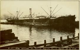
SS Arna arrived in Prince Rupert BC
2009.7.1.267 · Pièce · 30 March 1914
Fait partie de Archdeacon W. H. Collison fonds

Photograph of ocean liner SS Arna docked in a harbour. Foreground shows two individuals on a dock in the lower right corner and a large pile of lumber in the lower left corner. Annotation on recto reads: "S.S. Arna arrived in Prince Rupert B.C March 30th 1914"

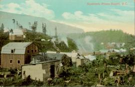
Squatters in Prince Rupert, BC
2011.3.3.116 · Pièce · [ca. 1909-1930]
Fait partie de North Coast & Central BC Postcard Collection

Hand coloured photo of various squatter's shacks and tents, with mountains in the background. Printed annotation on recto reads: "Squatters, Prince Rupert, B.C." Artist's stamp on lower right corner reads: "104,0033 J.V."

Speeches by W. Arthur Benson
2020.4.2.3.037 · Dossier · [1972?]
Fait partie de G. Gary Runka fonds

File consists of transcripts of speeches by W. Arthur Benson entitled "Demands for and of the Land" and "Land Information and its Relevance to Planning".

Speeches and Publications
2020.4.2 · Série organique · 1945-2009
Fait partie de G. Gary Runka fonds

Series consists of works written or collected by G. Gary Runka.

The 2020.4.2.1 Speeches sub-series includes manuscripts of speeches written by G. Gary Runka.

The 2020.4.2.2 G. Gary Runka Writing sub-series includes publications, manuscripts, and drafts of worked written, co-written, or edited by G. Gary Runka over the course of his career.

The 2020.4.2.3 Collected Works sub-series includes works collected by G. Gary Runka. Runka collected a comprehensive resource library of publications, reports, and rare grey literature that reflected the depth and breadth of natural resource issues in British Columbia. Material from this resource library was intrinsically tied to Runka's work; selected unique items from the resource library are contained within this sub-series to contextualize the scope of land management issues.

Speeches
2020.4.2.1 · Sous-série organique · 1969-2009
Fait partie de G. Gary Runka fonds

Subseries consists of speeches written and delivered by G. Gary Runka over the course of his career. Runka's earliest speeches relate to the Canada Land Inventory. While at the Agricultural Land Commission (ALC), Runka was often asked to present to various audiences on BC's unique agricultural land preservation program, the Agricultural Land Reserve (ALR). After leaving the ALC and setting up Land Sense Ltd., Runka continued to make presentations on the ALR, both specifically and in the context of rural land use conflict in general. Runka's key message was very consistent - the importance of first understanding the inherent biophysical messages of the land; then recognizing the complex challenges of sorting out who gets to use which rural lands for what purposes. Runka's speeches were often accompanied with 35mm slides from his slide collection. Unfortunately, however, the speeches do not include a listing of the slides that were used, although a notebook remains that contains references to slides used in presentations.

Sophia Suvee
2001.58.23 · Dossier · 1997-1998
Fait partie de Prince George Metis Elders Oral History Project Collection

File consists of an oral history given by Ruth Suvee regarding her mother, Sophia Suvee, which was gathered as part of Dr. Mike Evan's oral history project with the Prince George Metis Elders Society. Includes consent forms, transcripts, and the recorded oral history on the original cassette.

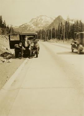
Snoqualmie Pass summit
2020.05.01 · Pièce · 6 June 1936
Fait partie de Gordon Wyness Album

Photograph depicts a man, likely Gordon Wyness, sitting on the front of a 1930 Buick Series 40 car at the Snoqualmie Pass summit.

"Small Lot Wastewater Management Study"
1996.8.4.62 · Dossier · 1982
Fait partie de Chander Suri fonds

File consists of a study on the management of small scale wastewater for the Regional District of Fraser-Fort George, prepared by Associated Engineering Services.

Slide Collection
2020.4.8.1 · Sous-série organique · 1968-2013
Fait partie de G. Gary Runka fonds

Gary Runka was a hobbyist photographer and documented his work and personal life through photography as he travelled across every region of British Columbia. This slide collection documents the evolution of British Columbia communities and regions over a 30 year period. Gary Runka's core interest was land and changing land uses. Many of these slides tell a story of urban edge and/or natural resource compatibility/conflict. There are also a substantial number of slides related to soils, including soil profiles, soil erosion and land (topography, drainage etc.) capability for agriculture. The collection also includes specific client-related photos, tied to Land Sense Ltd. client file job numbers.

The collection also documents personal travels and hiking trips throughout British Columbia and backpacking in some historic areas, such as West Coast Trail and Cape Scott. These slides also represent land evolution over time, including extent of alpine glaciation or biodiversity/plant species inhabiting the area.

Skeena, Nass, and Omineca regions
2012.13.2.19.19 · Dossier · 1984, 2011
Fait partie de J. Kent Sedgwick fonds

File consists of notes, clippings, and reproductions relating to the Skeena, Nass, and Omineca regions of British Columbia. Includes "Kitwanga Fort National Historic Site" pamphlet published by the Minister of the Environment Minister of Supply and Services Canada (1984).

2020.4.9.3.069 · Dossier · 1998
Fait partie de G. Gary Runka fonds

Floppy consists of G.G. Runka Land Sense Ltd. client file records for jobs.

Floppy directories and file listing:

  • CORK.DOC
  • INFOME3.DOC
  • OPED2.DOC
  • SIXMILE.DOC
  • SIXMILE.ED
  • SIXMILE.FAX
  • SIXMILE.FX2
  • SIXMILE.LTR
  • SIXMILE.MAC
  • SIXMILE.PRE
  • SIXMILE.REP
  • SIXMILE.TTL
Simon Fraser
2000.23.1.047 · Dossier · 1992-2000
Fait partie de Audrey Smedley L'Heureux fonds

File consists of collected research materials regarding Simon Fraser. Fraser was a Canadian explorer and fur trader who charted much of what is now the Canadian province of British Columbia. He also built the first European settlement in British Columbia at Fort McLeod. Materials include reproductions from BC Archives, such as photocopies of correspondence, booklets, reports, and newspaper clippings. Other highlights include:

  • The British Columbia Genealogist, Vol. 21 No.1 March 1993
  • The British Columbia Genealogist, Vol. 22 No.1 March 1993
Simon Fraser
2012.13.2.02.55 · Dossier · 2006-2008
Fait partie de J. Kent Sedgwick fonds

File consists of notes, clippings, and reproductions relating to research conducted by Kent Sedgwick on Simon Fraser, Canadian explorer and fur trader. Includes: "Simon Fraser: The Birth of Modern British Columbia" special edition issue of the Vancouver Sun newspaper (3 Jan. 2006).

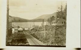
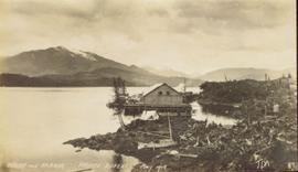
Side view of Prince Rupert wharf
2009.7.1.274 · Pièce · May 1908
Fait partie de Archdeacon W. H. Collison fonds

Side view photograph of a small harbor close by a shoreline littered in organic debris. A foggy mountain range is visible in the background. Annotation on recto reads: "Wharf and Harbor Prince Rupert. May 1908 JDA."

Sherry Lewis
2003.11.1.27 · Dossier · 1999-2000
Fait partie de Island Cache Recovery Project Collection

File consists of an oral history given by Sherry Lewis, which was gathered as part of Dr. Mike Evan's Island Cache Recovery Project. Includes consent forms, transcripts, and the recorded oral history on the original media.

Shelley
2012.13.2.17.17 · Dossier · 2001-2004
Fait partie de J. Kent Sedgwick fonds

File consists of notes, clippings, and reproductions relating to the community of Shelley.

Sharon Simmonds and Ken Switzer
2003.11.1.41 · Dossier · 1999-2000
Fait partie de Island Cache Recovery Project Collection

File consists of an oral history given by Sharon Simmonds and Ken Switzer, which was gathered as part of Dr. Mike Evan's Island Cache Recovery Project. Includes consent forms, transcripts, and the recorded oral history on the original media.