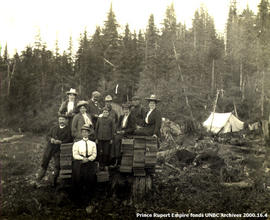
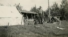
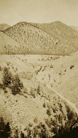
Photograph depicts Jack Lee with gear in front of a tent at Bobtail [Lake?] campsite after returning from Bobtail Mountain where the crew had camped overnight without a tent.
Photograph depicts (from left) Jack Lee and Philip Monckton leaning up against their 1930 Buick Series 40 car before leaving for Southbank Francois Lake. Behind them is the cabin they stayed in at Burns Lake, which was owned by Ben[?] Smith.
Photograph depicts (from left) Jack Lee and Gordon Wyness sitting on a car next to their equipment while surveying at an Indian Reserve. A cabin on the reserve is also depicted. According to the transcription on the photograph verso, they were surveying road through an "Indian Reserve South of South bank François Lake".
Photograph depicts Jack Lee (front) and Gordon Wyness drinking lakeside in Marble Canyon. The survey crew had been travelling along Marble Canyon Road, which is now Highway 99. The lakes in Marble Canyon are now named Turquoise Lake, Crown Lake, and Pavilion Lake. Wyness notes the blueness of these lakes and the white mountains of this area.
Photograph depicts Jack Lee and the survey crew's 1930 Buick Series 40 car below the Boston Bar tunnel on their return trip.
Photograph depicts MP Iona Campagnolo, a RCMP officer, and a customs officer standing in front of a boundary marker at the Canadian-American border between Hyder and Stewart.
Iona Campagnolo sitting and speaking with Mr. and Mrs. Solomon Doolan in Kincolith during the North Coast Council meeting and land claim presentation with the Kitimaat Band Council.
Minister Iona Campagnolo speaking at the North Coast District Council, three unidentified men and two unidentified women seated around her. Handwritten annotation on verso reads: “North Coast District Council”.
File consists of a speech given by Gary Runka entitled "Integrated Natural Resource Management" to the 4th Annual BC Mine Reclamation Symposium in Vernon, BC.
File consists of a speech given by Gary Runka at UBC entitled "Integrated Land Use - BC Experience".
Commentary on this speech by Barry Smith of the Ministry of Agriculture and Lands:
"The speech provides insight into GGR's concept of integrated land use as opposed to multiple land use.
Agriculture noted as often the 'primary use for land designated in the ALR'. On page 5 GGR reflects on this concept when stating that integrated land use planning is a useful first step "... to indicate the primary physical capability of each landform based on inherent soil and climatic characteristics".
The speech was accompanied by slides."
Several large buildings on a rocky shore. Wood piles and a crane are visible in the background. Annotation on recto reads: "Prince Rupert BC"
Hugh Faulkner, Kitamaat Band Council members, and an unknown man sitting at a table talking during the Kitamaat Band North Coast District Council meeting and land claim presentation.
Hugh Faulkner is sitting at a table and speaking into a recording device that is held by two men. A third man is sitting with his back to the camera.
Hugh Faulkner and Kitamaat Band Council members sitting at a table talking during the Kitamaat Band North Coast District Council meeting and land claim presentation.
Many people are seated around a meeting table. Hugh Faulkner is at the head of the table, seated beside a flip chart with the word "Agenda" written at the top.
Photograph depicts the townsite of Hudson's Hope featuring a number of small wooden buildings clustered in a field. The Hudson's Bay post is building visible on far left.
Photograph depicts the Hudson Bay buildings at Fort St. James.
Item is a hand drawn and coloured map by the City of Prince George Planning Department depicting Hart Highway neighbourhood area existing land use in 1976.
Zonder titelThis external hard drive contains back-up files from Gary Runka and Joan Sawicki's computers. The digital files consist of personal, professional, and business records. Includes textual documents (PDF and Word format), spreadsheets (Excel), digital images (JPEG), and email backup files.
File consists of a speech given by Gary Runka entitled "Habitat, Land Use Planning, Economics and the Land Owner" to the 43rd Federal-Provincial Wildlife Conference in Regina.
Photograph of a partially sunken sailboat near a harbour. Individuals on debris and in a rowboat are surveying the damage. Annotation on recto reads: "GTP. SS Prince Rupert Sept 28th 1920 McRae." Handwritten annotation on verso reads "CTP "Prince Rupert" Sunk at Prince Rupert BC 1920."
The group stands against wall, banquet tables in foreground.
Handwritten annotation on verso reads: “Minister DINA Hugh Faulkner + Kitamaat Band Council for Land Claim presentation”.
Group shot of Hugh Faulkner and the Kitimaat Band Council at a land claims presentation during the North Coast District Council meeting. Eight council members are pictured.
The group stands against wall, banquet tables in foreground.
Handwritten annotation on verso reads: "Minister DINA Hugh Faulkner + Kitamaat Band Council for Land Claim presentation".
Photograph depicts a group of people leaning up against the survey crew's Buick car in Francois Lake. Based on the transcription on the photograph verso, from left to right the individuals are: "Mrs. Hunter", "Bobby", Jack Lee, "Edna", "Verna", "Banker's wife", and Gordon Wyness.
Item is a copy print of a photograph of a group of people in a cleared area with a small tent in the background in Prince Rupert on June 1, 1906. The people in the photograph are identified as: Mrs. J.L. Williams, Jack or Jock Williams, Mrs. Porter, Miss Mai Johnston, Mrs. R.L. McIntosh, J.H. Pillsbury, Mr. Pinder ? (Engineer), Captain Jenner ?, Mrs. S.G. Harris, and Cannon Rushbrook.
Photograph depicts (from left to right) Gordon Wyness, Philip Monckton, and Lavender Monckton by their 1930 Buick Series 40 car in the Williams Lake area. In this image, the car may be broken down; Wyness noted that they "were forced to spend the nite in a school house due to condenser burning out in the car". Wyness also noted that they had "just finished tying in Fraser Mtn", suggesting that they had just completed survey work in the Fraser Mountain area.
Photograph depicts (from left to right) Gordon Wyness, Louis LeBourdais, and Earl Malcolm (owner of Quesnel Hotel) standing in front of a 1930 Buick Series 40 car at Twilight Lodge in Lac La Hache, BC. The group was preparing to leave for Prince George.
Photograph depicts Gordon Wyness sitting on a historic boat, which he described as built ca. 1860 and could carry "7 Indians" and 5000 lbs of freight up the river. Located nearby is a telegraph cairn erected to commemorate the Collins Overland Telegraph lines that began in Quesnel in 1865. Until 1907, Quesnel was the terminus for the telegraph line. Behind Wyness is a replica of a Cornish water wheel that was originally located at Williams Creek in Barkerville. This location is now called Ceal Tingley Memorial Park-Heritage Corner and is located along Front Street in Quesnel, near the Fraser River Bridge. The cairn and water wheel still stand in this location, however the boat was removed around 1941.
According to additional information from Quesnel & District Museum & Archives, Wyness may have been provided with inaccurate information about the canoe depicted. The canoe believed to have been located at that spot was actually created in 1905 to pack out the Grand Trunk Preliminary Survey Team, which was led by J.M. Rolston.
Photograph depicts Gordon Wyness at the Bobtail campsite after having just returned from a night of camping without a tent on Bobtail Mountain. Wyness noted (on photograph verso) that there were pack rats in the telegraph cabin in the background of this photograph.
Photograph depicts (from left to right) Gordon Wyness and Jack Lee in front of the Fort St. James sign, which reads "First white settlement in British Columbia. Established by the North West Company in 1806 by Simon Fraser and John Stuart and taken over by the Hudson's Bay Company in 1821. - General Merchandise Visitors Welcome".
Photograph depicts (from left to right) Gordon Wyness and Jack Lee at a camp scene "at Bobtail" (possibly Bobtail Lake) near Vanderhoof. As noted in the album caption, the crew had "just returned from Vanderhoof". The telegraph cabin roof and their 1930 Buick Series 40 car is visible at right.
In 1936, Gordon Young Wyness was employed by Philip M. Monckton, a B.C. Land Surveyor. Between June 5 and October 8, Wyness joined Monckton and a group of others on a land survey expedition in northwestern BC. The survey crew travelled to various locations in the area including Telkwa, Hazelton, Burns Lake, Francoise Lake, Vanderhoof, Prince George, Quesnel, Lytton, and Hope. Wyness documented their journey in this photograph album. Based on the photographs, it appears that the crew led by Philip Monckton consisted of Jack Lee and Gordon Wyness; Mrs. Lavender Monckton (nee O'Hara) also accompanied the group.
In addition to the 50 photographs included in the album, this collection also includes five additional unique photographs that accompanied the album.
Zonder titelPhotograph depicts Gary Runka receiving a Agricultural Institute of Canada Fellow award at the 1990 AIC Convention at the Penticton Conference Centre.
This fonds illustrates the life and work of G. Gary Runka and his contributions to the province of British Columbia. Gary Runka was the first General Manager of British Columbia's Agricultural Land Commission and helped establish the provincial Agricultural Land Reserve. After transitioning from a government career to private consulting, Runka provided comprehensive professional services through his land consultancy business, G.G. Runka Land Sense Ltd., offering land capability and environmental assessments, integrated resource management, land and water use conflict resolution, and interdisciplinary land use planning. Described by colleagues as one of BC's most highly respected agrologists and influential land use planners, Runka had a 52-year career working on (or against) an incredible number of landmark projects in British Columbia, such as the Site C Project. Gary Runka’s partner in life and vocation, Joan M. Sawicki, worked with Gary on many of these projects—as well as her own; her contributions are also represented throughout the records of this fonds.
Gary Runka's deep connection to the land is evident from his earliest papers on aerial photo interpretation, his work with the Canada Land Inventory, through his speeches and his work establishing the BC Agricultural Land Reserve and in his subsequent consulting career through G.G. Runka Land Sense Ltd. Gary Runka's influence and legacy was recognized in the tributes paid after his death, including the post-humus award as the Real Estate Foundation's "Land Champion" for 2014.
The G. Gary Runka fonds has been divided into the following nine series:
1) Personal Records
2) Speeches & Publications
3) Professional Records
4) Agricultural Land Commission
5) Land Sense Ltd.
6) Client Files
7) Maps
8) Photographs
9) Digital Records
File consists of a speech given by Gary Runka entitled "Future of Intensive Livestock Enterprises in the more densely populated areas of the Agricultural Land Reserve" for the Agricultural Engineering Branch of the BC Ministry of Agriculture.
Commentary on this speech by Barry Smith of the Ministry of Agriculture and Lands:
"In the letter dated December 29,1978, from GGR to Pat Brisbin (Secretary, Engineering Science Lead Committee), GGR refers to the enclosure as "the notes pertaining to my submission" that presumably was made at a meeting of the Engineering Science Lead Committee on December 21,1978.
The thrust of this item is to address the matter of intensive livestock farming in areas within close proximity to urban uses - e.g. in the ALR and along the urban / rural edge.
The 'notes" include a list of twelve "considerations" that should be taken into account when dealing with livestock enterprises on the urban edge.
Six 'actors' and their responsibilities are identified including:
- The Agricultural Land Commission;
- Ministry of Agriculture;
- Local Governments;
- BC Federation of Agriculture;
- Intensive Livestock Operators; and
- Non-farming Public.
It is emphasized that there is a need for communications between these actors and a need for education to avoid conflicts but makes clear that intensive agriculture shall be retained in the ALR.
The paper ends with a series of considerations - Philosophical / Social and Political Pressure / Financing and Tenure / Environmental - Pollution / Waste Disposal.
This paper demonstrates the long standing nature of concerns associated with intensive livestock operations near urban areas and the need for "edge planning"."
Photograph depicts a view of Fraser River from a location near Marguerite, BC.
Photograph depicts a view of François Lake taken from the ferry going to Northbank Point on right-hand side. The survey crew camped there in June 1936.
Photograph depicts the Francois Lake Ferry. Gordon Wyness stands next to the survey crew's Buick car in the middle of the boat. Jack Lee leans on the railing at the back of the boat.
Photograph of a large crowd gathered in front of a Grand Trunk Pacific train. Residential buildings atop a hill are visible in the background. Annotation on recto reads: "First Train Leaving Prince Rupert June 14 1911"
Pile driver situated on Prince Rupert shoreline. Tents and wooden buildings visible on rocky background. Printed annotations on recto of photograph read: "First pile driven at Prince Rupert BC. June 8 '06."
Photograph is a group portrait of the attendees at the Federal-Provincial Canada Land Inventory Coordinators Meeting in Victoria, March 31-April 1, 1971. Starting from the back row, left to right, attendees included: John Senyk, B.C.; Jim Allin, B.C.; Fred Frederickson, B.C.; Red Ward, Ontario; George Rathwell, Saskatchewan; John Foster, Ottawa, Charlie Rowles, B.C.; David Glover, Ottawa; Bill Yeomans, B.C.; Don Coombs, Ottawa; Harold Hoyt, N.B.; Brian King, Ottawa; Art Benson, B.C.; Scott Johnston, Ottawa; Dan Blower, B.C.; Vic Solman, Ottawa; Don Benn, B.C.; Dick Spilsbury, B.C.; Les Lavkulich, B.C.; Doug Lacate, B.C.; John Wilcox, B.C.; Alf Leahey, B.C.; Mike Romaine, Ottawa; Dick Marshall, B.C.; Gary Runka, B.C.; Norm Sprout, B.C.; Ken Beanlands, Newfoundland; Mick Roberts, Ottawa; Paul Lajoie, Ottawa; Pat Duffy, Ottawa; Bert Brink, B.C.; Merv McKay, Manitoba; Rich Goulden, Manitoba; Reg McCormack, Ottawa; Gerry Howell-Jones, B.C.; Marcel Belzile, Quebec; Paul Deane, Ottawa; Laurie Farstad, B.C.; Stu Scott, Alberta.
File consists of a speech given by Gary Runka entitled "Expanding Needs from a Finite Resource: the Necessity for Sound Land Use Planning" for the Manitoba Land Use Conference Land User for the 80's - Private Rights and Public Interests, March 11 & 12,1981.
Commentary on this speech by Barry Smith of the Ministry of Agriculture and Lands:
"The conference theme of "Private Rights and Public Interests" is one that GGR often turned to. In this fairly lengthy speech GGR pulls together, in one paper, many of the themes and positions he has turned to in other speeches. He explains the 'land and water maze' and lists 12 uses competing for limited land and water resources. It is noted that the imbalance between agriculture vs urban uses, due to urban uses commanding much higher values resulting in agriculture finding itself in a defensive position, is discussed.
As the conference theme enunciates - GGR explores the tug-of-war between the myth of limitless land and community needs vs property rights and the fallacy that individual land use decisions do not impact the larger community. GGR emphasises the slowness of changing attitudes and the even slower political response and policy change. The confusion of jurisdiction concerning what level of government is best positioned to deal with resources issues is considered. GGR emphasizes the need to plan the use of land resources in an integrated and comprehensive fashion and the need for shared decision making.
Policy 3 of Manitoba's Regulation #217/80 - "Rural residential development should not be thought of, nor normally planned, as an evolutionary step from a rural landscape to an urban development" is noted. It is emphasized that the planning process has to catch up with the rural reality.
Central message - the importance of planning land and water use must be in keeping with the natural characteristics of the land and the needs and values of the local community. This latter point is of interest from the point of view that local community values and plans may dash with provincial values or policy."
File consists of a speech given by Gary Runka entitled "Effects of Urban Decision Making on Rural Issues".
Commentary on this speech by Barry Smith of the Ministry of Agriculture and Lands:
"The introduction begins by stating that urban-oriented people are making decisions that impact on rural issues and land / people relationships. This paper provides a perspective largely from a rural point of view although, at the very end it is concluded that people in rural areas are often unaware of the dynamics of urban needs and priorities.
While the examples of urban influences on rural areas are too numerous to comprehensively outline even in a 16 page speech, GGR does cover a lot of ground in this regard in the paper. He feels that through careful planning built on understanding we can, as a society, achieve a comfortable balance.
The question is asked, who is rural and who is urban - there is a degree of blurring. The paper considers urban decision-making in the broadest context - whether political, economic or social.
The paper is broken into a consideration of urban decision making and its effects on rural areas from a number of points of view - (1) Political; (2) Economic; and (3) Lifestyle.
It is noted that there is a need for greater understanding of agriculture from both a rural and urban point of view and the spin-offs of food and fibre production in providing jobs in the urban community is not widely recognized by urban citizens or elected officials.
As the number of urbanites take up residence in rural areas their power at the local ballot box also increases. Three examples of urban decision making on rural issues are explored including:
(1) The "Killer" Mall;
(2) The "Suburban" Horse; and
(3) Soil Conservation.
Interdependence is specifically emphasized - there is seldom any decision taken that does not impact to some degree somewhere else along the urban-rural continuum."
Photograph depicts the Ponderosa Pine and bunch grass dry biogeoclimatic zone near Lytton in October 1936.