Title and statement of responsibility area
Title proper
General material designation
Cartographic material
Parallel title
Other title information
Title statements of responsibility
Title notes
Level of description
Reference code
Edition area
Edition statement
Edition statement of responsibility
Class of material specific details area
Statement of scale (cartographic)
Statement of projection (cartographic)
Statement of coordinates (cartographic)
Statement of scale (architectural)
Issuing jurisdiction and denomination (philatelic)
Dates of creation area
Date(s)
-
1893 (Creation)
Physical description area
Physical description
1 map : col. photolithograph ; 77 x 98 cm (encapsulated)
Publisher's series area
Title proper of publisher's series
Parallel titles of publisher's series
Other title information of publisher's series
Statement of responsibility relating to publisher's series
Numbering within publisher's series
Note on publisher's series
Archival description area
Custodial history
Donated to Northern BC Archives 3 May 2002.
Scope and content
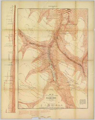
Consists of 1 topographical map with red colouring entitled "Map of Placer Mines & Quartz Locations in the Vicinity of Williams Creek, Cariboo District B.C." Surveyed and Drawn by Amos Bowman, Mining Engineer, Assisted by James McEvoy, B.A. Sc., printed by the Geological Survey Department, Canada.
Notes area
Physical condition
Immediate source of acquisition
Arrangement
Language of material
Script of material
Location of originals
Availability of other formats
Digitized and available in JP2 and TIFF formats.
Restrictions on access
No restrictions.
Terms governing use, reproduction, and publication
Personal or academic use of materials is welcomed under the standard fair dealing and educational use clauses of Canadian Copyright Law. Commercial use is, however, forbidden without the express permission of the copyright holder. For information on obtaining written permission from the copyright holder, please contact the Northern B.C. Archives and Special Collections.
Finding aids
Associated materials
Accruals
General note
General note
Scale 1.5" = 1000.' Includes a longitudinal cross-section of Williams Creek. Areas of significant geological deposits and mining are identified. Surveys carried out with the co-operation of the Provincial Government of British Columbia, The Hon. John Robson, Minister of Mines. Drawn for Photolithography by L.N. Richard, B. App. Sc. To Illustrate Report of A. Bowman, Mining Engineer