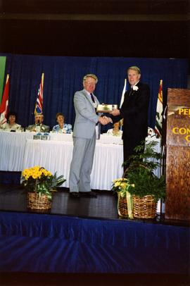
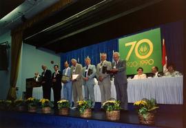
Penticton, BC

Elements area

Taxonomy

Code

Scope note(s)

    Source note(s)

      Display note(s)

        Hierarchical terms

        Penticton, BC

          Equivalent terms

          Penticton, BC

            Associated terms

            Penticton, BC

              40 Archival description results for Penticton, BC

              40 results directly related Exclude narrower terms
              CNR slip in Penticton
              2013.6.36.1.022.04 · Item · [22 July 1968]
              Part of David Davies Railway Collection

              Photograph depicts a CNR slip in Penticton on Okanagan Lake. It shows a general view of the slip and unloading operations, plus a road and rail tractor.

              CNR slip in Penticton
              2013.6.36.1.022.05 · Item · [22 July 1968]
              Part of David Davies Railway Collection

              Photograph depicts a CNR slip in Penticton on Okanagan Lake. It shows a general view of the sidings leading from the barge slip . The tractor could move two cars on the level, but did not move cars to and from the barge. The winch was used to pull all cars, including tank cars, onto the barge.

              CNR slip in Penticton
              2013.6.36.1.022.02 · Item · [22 July 1968]
              Part of David Davies Railway Collection

              Photograph depicts a CNR slip in Penticton on Okanagan Lake. The first two cars are being removed from a barge. There is a gas driven winch on the after port of the barge. A cable is taken around a pulley (white in the middle ground) and then attached to the frame of the 1st car- as shown in this photo. This gets the cars moving and gravity plus the brakes does the rest.

              CNR slip, Penticton
              2013.6.36.1.055.34 · Item · [22 July 1968]
              Part of David Davies Railway Collection

              Photograph depicts CN tug #6 (built in 1948) with a rail barge, empty cars (used for fruit), and one returned empty explosives car from Peachland.

              CPR tug, Penticton
              2013.6.36.1.055.33 · Item · [July 1966]
              Part of David Davies Railway Collection

              Photograph depicts a CPR tug named the "Okanagan" that was assembled at the Okanagan landing. It usually tooks 3 hours and 10-15 minutes to travel from Kelowna to Penticton with one rail scow in tow.

              2013.6.36.1.022.19 · Item · [July 1979]1979
              Part of David Davies Railway Collection

              Photograph depicts the disused CPR Kettle Valley Railway line in Penticton. The trackage leads from the Okanagan Lake CPR wharf to the main yards. All the trackage was obliterated by July 1981. The photo was taken about 1 block away from the lake and near Brunswick St. The view is looking southwest.

              2020.4.6.205 · File · 1987
              Part of G. Gary Runka fonds

              File consists of records created and accumulated by Gary Runka over the course of his consultancy work for IMC Consulting Group Inc. for Penticton Indian Band for the "Preliminary Opinion of Agricultural Opportunities - Penticton Indian Band Economic Development Opportunities Study" project in Penticton. This file was numbered as G.G. Runka Land Sense Ltd. client file #205; that client number may be seen referenced elsewhere in the G. Gary Runka fonds. Includes correspondence, invoices, photocopied map areas, handwritten notes, and reports.

              Includes the following:

              • Promotional booklet for Rogers Ranch
              • Report by IMC Consulting Group Inc. for Penticton Indian Band entitled "Draft Land Use Plan and Economic Development Strategy", February 1989
              • G. Gary Runka for IMC Consulting Group, "Preliminary Opinion of Agricultural Opportunities, Penticton Indian Reserve #1"
              • Report by IMC Consulting Group Inc. for Penticton Indian Band entitled "Proposal for Community Economic Development Opportunities Study for the Penticton Indian Band", September 1987

              Maps include:

              • [G.G. Runka Land Sense Ltd.?], "Provisional Land Capability for Agriculture - Penticton Indian Reserve No. 1 - 82E033", ca. 1987.
              • [G.G. Runka Land Sense Ltd.?], "Provisional Land Capability for Agriculture - Penticton Indian Reserve No. 1 - 82E094", ca. 1987.
              • [G.G. Runka Land Sense Ltd.?], "Provisional Land Capability for Agriculture - Penticton Indian Reserve No. 1 - 82E073", ca. 1987.
              • [G.G. Runka Land Sense Ltd.?], "Provisional Land Capability for Agriculture - Penticton Indian Reserve No. 1 - 82E093", ca. 1987.
              • [G.G. Runka Land Sense Ltd.?], "Provisional Land Capability for Agriculture - Penticton Indian Reserve No. 1 - 82E083", ca. 1987.
              • [G.G. Runka Land Sense Ltd.?], "Provisional Land Capability for Agriculture - Penticton Indian Reserve No. 1 - 82E012", ca. 1987.
              • [G.G. Runka Land Sense Ltd.?], "Provisional Land Capability for Agriculture - Penticton Indian Reserve No. 1 - 82E011", ca. 1987.
              • [G.G. Runka Land Sense Ltd.?], "Provisional Land Capability for Agriculture - Penticton Indian Reserve No. 1 - 82E013", ca. 1987.
              • [G.G. Runka Land Sense Ltd.?], "Provisional Land Capability for Agriculture - Penticton Indian Reserve No. 1 - 82E021", ca. 1987.
              • [G.G. Runka Land Sense Ltd.?], "Provisional Land Capability for Agriculture - Penticton Indian Reserve No. 1 - 82E084", ca. 1987.
              • [G.G. Runka Land Sense Ltd.?], "Provisional Land Capability for Agriculture - Penticton Indian Reserve No. 1 - 82E003", ca. 1987.
              • [G.G. Runka Land Sense Ltd.?], "Provisional Land Capability for Agriculture - Penticton Indian Reserve No. 1 - 82E022", ca. 1987.
              • [G.G. Runka Land Sense Ltd.?], "Provisional Land Capability for Agriculture - Penticton Indian Reserve No. 1 - 82E031", ca. 1987.
              • [G.G. Runka Land Sense Ltd.?], "Provisional Land Capability for Agriculture - Penticton Indian Reserve No. 1 - 82E053", ca. 1987.
              • [G.G. Runka Land Sense Ltd.?], "Provisional Land Capability for Agriculture - Penticton Indian Reserve No. 1 - 82E063", ca. 1987.
              • [G.G. Runka Land Sense Ltd.?], "Provisional Land Capability for Agriculture - Penticton Indian Reserve No. 1 - 82E002", ca. 1987.
              • [G.G. Runka Land Sense Ltd.?], "Provisional Land Capability for Agriculture - Penticton Indian Reserve No. 1 - 82E043", ca. 1987.
              • [G.G. Runka Land Sense Ltd.?], "Provisional Land Capability for Agriculture - Penticton Indian Reserve No. 1 - 82E032", ca. 1987.
              • [G.G. Runka Land Sense Ltd.?], "Provisional Land Capability for Agriculture - Penticton Indian Reserve No. 1 - 82E042", ca. 1987.
              • [G.G. Runka Land Sense Ltd.?], "Provisional Land Capability for Agriculture - Penticton Indian Reserve No. 1 - 82E023", ca. 1987.
              2020.4.6.244 · File · 1989
              Part of G. Gary Runka fonds

              File consists of records created and accumulated by Gary Runka over the course of his consultancy work with McKay, Rivard and Co. Ltd. for Penticton Indian Band for the "Analysis of Land Suitability for Irrigated Crops, Penticton Indian Reserve #1" project regarding assessment of alleged soil degradation on Skeetchestn Indian Reserve #1. This file was numbered as G.G. Runka Land Sense Ltd. client file #244; that client number may be seen referenced elsewhere in the G. Gary Runka fonds. Includes correspondence, invoices, photocopied map areas, handwritten notes, photocopied legal documents, and reports.

              Includes the following:

              • J.W. Ngai, BC Ministry of Environment, "Penticton Indian Band Proposed Irrigation Water Supply Project Preliminary Study", July 1980
              • "Penticton Indian Band Proposed ARDSA Irrigation Project - Potential Irrigable Areas and Distribution System", BC Ministry of Environment Inventory and Engineering Branch, July 1980
              • G. Gary Runka for Indian and Northern Affairs Canada, Public Works Canada, and Department of Justice, "Assessment of Alleged Soil Degradation on Parcel C, Plan 53050, Skeetchestn Indian Reserve #1"
              • Flynn & Associates, "Appraisal of Merryfield Leases, Deadman's Creek Indian Reserve", April 1983
              • John T. Crowe of Flynn & Associates for Deadman's Creek Indian Band, "Appraisal of Agricultural Land, Deadman's Creek Indian Reserve", April 1985

              Maps include:

              • Ministry of Environment, "Brent Lake South Dam - To accompany report on Penticton Indian Band Proposed ARDSA Irrigation Project", July 1980.
              • Ministry of Environment, "Brent Lake North Dam - To accompany report on Penticton Indian Band Proposed ARDSA Irrigation Project", July 1980.
              • Ministry of Environment, "Brent Lake Storage Development General Layout - To accompany report on Penticton Indian Band Proposed ARDSA Irrigation Project", July 1980.
              • Ministry of Environment, "Potential Irrigable Areas and Distribution System - To accompany report on Penticton Indian Band Proposed ARDSA Irrigation Project", July 1980.
              • Ministry of Environment, "Brent Lake Reservoir - Cross-Sections of Dam - Storage Inventory Programme Okanagan Basin - Columbia System", Jan. 1981.
              • Ministry of Environment, "Brent Lake Reservoir - Topographic Map of North End of Brent Lake including existing diversion from Shingle Creek - Storage Inventory Programme Okanagan Basin - Columbia System", Jan. 1981.
              • Ministry of Environment, "Brent Lake Reservoir - Plan of Reservoir - Storage Inventory Programme Okanagan Basin - Columbia System", Jan. 1981.
              • Ministry of Environment, "Brent Lake Reservoir - Storage and Basin Data Accompanying Plan of Reservoir - Storage Inventory Programme Okanagan Basin - Columbia System", Jan. 1981.
              • Ministry of Environment, "Brent Lake Reservoir - General Plan and Longitudinal-Section of Dam, Longitudinal-Section and Cross-Sections of Spillway Channel - Storage Inventory Programme Okanagan Basin - Columbia System", Jan. 1981.
              • Ministry of Energy, Mines and Resources Canada, "Photomap of Part of Pentiction I.R. 1, I.R. 3a - Osoyoos Division of Yale District, British Columbia" with survey overlay, Sheet 1 of 5, 1986
              • Ministry of Energy, Mines and Resources Canada, "Photomap of Part of Pentiction I.R. 1 - Similkameen and Osoyoos Division of Yale District, British Columbia" with survey overlay, Sheet 3 of 5, 1986
              • G.G. Runka Land Sense Ltd. using IMC Consulting Group base map, Penticton Indian Band Map 1 - draft map with no legend
              • G.G. Runka Land Sense Ltd. using IMC Consulting Group base map, Penticton Indian Band Map 1 - annotated draft map showing land use
              • G.G. Runka Land Sense Ltd. using IMC Consulting Group base map, Penticton Indian Band Map 2 - annotated draft map showing land use
              • G.G. Runka Land Sense Ltd. using IMC Consulting Group base map, Penticton Indian Band Map 3 - annotated draft map on transparency (2 copies)
              • G.G. Runka Land Sense Ltd. using IMC Consulting Group base map, Penticton Indian Band Map 3 - draft map with no legend (7 copies)
              • G.G. Runka Land Sense Ltd. using IMC Consulting Group base map, Penticton Indian Band Map 3 - edited to show "Annual Water Requirements and Peak Flow/Acre"
              • G.G. Runka Land Sense Ltd. using IMC Consulting Group base map, Penticton Indian Band Map 3 - edited to show "Land Suitability for Irrigated Crops", June 1989 (4 copies)
              • Energy, Mines and Resources Canada, "Survey Overlay Photomap of Part of Penticton I.R. 1 - Osoyoos Division of Yale District, British Columbia", Sheet 2 of 5, Sept. 1986
              • Energy, Mines and Resources Canada, "Survey Overlay Photomap of Part of Penticton I.R. 1 - Similkameen Division of Yale District, British Columbia", Sheet 4 of 5, Sept. 1986
              2020.4.6.245 · File · 1989
              Part of G. Gary Runka fonds

              File consists of records created and accumulated by Gary Runka over the course of his consultancy work for Penticton Indian Band for the "Analysis of and Suitability for Irrigated Crops and Consultation on Water Management Strategy" project in Penticton. This file was numbered as G.G. Runka Land Sense Ltd. client file #245; that client number may be seen referenced elsewhere in the G. Gary Runka fonds. The Land Sense Ltd. client files generally include records such as correspondence, contracts, invoices, project reports, publications, ephemera, memoranda, maps or map excerpts, legal documents, meeting materials, clippings, and handwritten notes.

              Includes the following:

              • Urban Systems Limited for Penticton Indian Band, "Water Demand Study for the Penticton Indian Band", June 1990

              Includes the following maps:

              • Land Sense Ltd. and Craig Brownlee for Penticton Indian Band, "Annual Water Requirements and Peak Flow/Acre", July 1989.
              • Urban Systems Ltd., "Penticton Indian Band Future Land Use - P.I.R. No. 1 - Appendix 1", April 1990.
              2020.4.6.556 · File · 2001
              Part of G. Gary Runka fonds

              File consists of records created and accumulated by Gary Runka over the course of his consultancy work for Land Conservancy of British Columbia for the "Penticton Indian Band Riparian Ecosystem Conservation Education Project in Penticton for En'Owkin Centre and Land Conservancy of BC on behalf of South Okanagan-Similkameen Conservation Program Habitat Securement Team" project in Penticton. This file was numbered as G.G. Runka Land Sense Ltd. client file #556; that client number may be seen referenced elsewhere in the G. Gary Runka fonds. The Land Sense Ltd. client files generally include records such as correspondence, contracts, invoices, project reports, publications, ephemera, memoranda, maps or map excerpts, legal documents, meeting materials, clippings, and handwritten notes. File also includes 93 accompanying photographs. Also includes an oversize enlargement of BC air photo 30BCC96045 No. 181.

              2020.4.6.564 · File · 2001
              Part of G. Gary Runka fonds

              File consists of records created and accumulated by Gary Runka over the course of his consultancy work for En'owkin Centre and The Land Conservancy of B.C. for the "An Opportunity - Penticton Indian Band Riparian Ecosystem Conservation Education Project" in Penticton. This file was numbered as G.G. Runka Land Sense Ltd. client file #564; that client number may be seen referenced elsewhere in the G. Gary Runka fonds. The Land Sense Ltd. client files generally include records such as correspondence, contracts, invoices, project reports, publications, ephemera, memoranda, maps or map excerpts, legal documents, meeting materials, clippings, and handwritten notes.

              2020.4.6.065 · File · 1982
              Part of G. Gary Runka fonds

              File consists of records created and accumulated by Gary Runka over the course of his consultancy work for Environment Canada, Lands Directorate for the "Okanagan Fruitlands: The Location, Nature, Amount and Rate of Land Use Change (Report to Accompany Land Use Change Maps)" project in Penticton South. This file was numbered as G.G. Runka Land Sense Ltd. client file #065; that client number may be seen referenced elsewhere in the G. Gary Runka fonds. The Land Sense Ltd. client files generally include records such as correspondence, contracts, invoices, project reports, publications, ephemera, memoranda, maps or map excerpts, legal documents, meeting materials, clippings, and handwritten notes.

              Includes map:

              • "Okanagan Fruitlands Study - Land Converted to Built-up Uses 1958-1981; Agricultural Land Reserves and Built-Up Uses in 1981; Land Use in 1981", [1982?]
              US military plane
              2013.6.36.1.084.16 · Item · 2 Aug. 1981
              Part of David Davies Railway Collection

              Photograph taken at the Penticton Airport where WWII military airplanes meet. This US military plane was flown by a US Air Militia on a courtesy visit. It was built in the early 1950's.