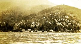
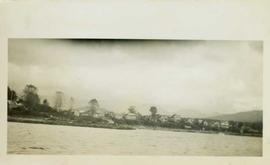
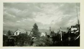
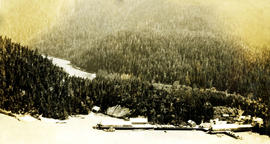
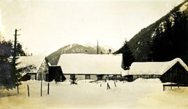
Nass River, BC

Elements area

Taxonomy

Code

Scope note(s)

    Source note(s)

      Display note(s)

        Hierarchical terms

        Nass River, BC

          Equivalent terms

          Nass River, BC

            Associated terms

            Nass River, BC

              89 Archival description results for Nass River, BC

              89 results directly related Exclude narrower terms
              Winter at Nass Harbour
              2009.10.1.51 · Item · Dec. 1927
              Part of Fred Jeffery Photograph Collection

              Photograph depicts a snowy foreground, simple houses in the midground and snowy mountains in the background. Handwritten annotation below photograph reads, "Winter at Naas Dec. 1927".

              2009.7.1.137 · Item · [ca. 1910?]
              Part of Archdeacon W. H. Collison fonds

              Three men can be seen on deck of small boat. Rocky shore in foreground, forest and hills on opposite shore in background.

              Handwritten annotations on verso read: "Dad - en route up Nass River on official business. (hence the flag & business suit!)"; "Going up the Nass. Dad (Indian Agent) Cap Barry (Inspect. of Schools) travelling up the Nass River to Aiyansh".

              2009.7.1.140 · Item · [ca. 1925?]
              Part of Archdeacon W. H. Collison fonds

              Group of six men sit and stand on small boat close to shore. Rev. W.E. Collison stands on far right (son of Marion and Archdeacon W.H. Collison).

              Handwritten annotation on verso reads: "Dr. Macdonald Med officer (Kincolith) / Dr. [McQuarrie?] Med officer Victoria / Steven Clayton Native boat owner / Capt. Bary - Insp. of Indian Schools / W.E. Collison Indian agent. / Inspection trip to villages of upper Nass River".

              2023.7.2.01 · File · 1985
              Part of Grant Hazelwood fonds

              File consists of project planning documents for the BC Ministry of Environment's "Upper Nass Assessment Project", a project that included the biophysical mapping of the Northwest-Klappan Road Access Area. Grant Hazelwood (Alpenglow Resources) was hired as the wildlife biologist for to undertake this project work. Includes Hazelwood's employment information for the project, project terms of reference, and a project summary.

              2023.7.2.02 · File · 1984-1986
              Part of Grant Hazelwood fonds

              File consists of Grant Hazelwood's notes and collected correspondence created in conjunction with the BC Ministry of Environment's "Upper Nass Assessment Project", a project that included the biophysical mapping of the Northwest-Klappan Road Access Area. Includes a summary document entitled "Klappan Access Road Project - Wildlife Component", as well as Hazelwood's handwritten species inventory notes.

              2009.21.27 · Item · [ca.1932]
              Part of Thomas Crosby Mission Ship Photograph Collection

              Three women, two wearing hats and pants and one in a dress, stand together in front of what is possibly the Hudson's Bay Store. The woman on the left is Mrs. Huston, wife of the Hudson's Bay Company store manager. Handwritten annotation on verso reads: "Light House caretakers, wife in centre, Lady with cap on, wife of ....the Hudson Bay Store at 1932 ."

              2009.21 · Collection · 1932-1946

              Subject areas identified in this collection include: church and hospital buildings (including nurses quarters); group photos featuring doctors, nurses, and hospital workers; grave markers; landscapes; processing of oolichan fish; and various church-related events such as weddings and church openings.

              Thomas Crosby Mission Ships
              2023.7.2.04 · File · May 1984
              Part of Grant Hazelwood fonds

              File consists of a copy of "Preliminary Environmental Assessment of Railway Corridor Options to Service Mount Klappan Coal Project and the Northwest Region of British Columbia" (1984) by the Industrial and Energy Project Evaluation Section, Planning and Assessment Branch of the BC Ministry of Environment.

              2009.7.1.150 · Item · [ca. 1878 - ca. 1915]
              Part of Archdeacon W. H. Collison fonds

              Photograph features a steep cliff across water, rocky shore in foreground.

              Handwritten annotation on verso reads: "Up the 'Big Creek' at Kincolith B.C. Rock face called 'the place of echoes' by the Indian people."

              Photographs
              2009.7.1 · Series · [ca. 1873 - ca. 1939]
              Part of Archdeacon W. H. Collison fonds

              Series consists of images pertaining the Collison family, North Coastal First Nations communities, means of transportation along North Coastal British Columbia, and various church structures and religious events.

              2003.13 · Collection · [after 1909]

              Consists of two photograph albums that illustrate Parker Bonney's early years as a Forest Engineer. Includes photographs of the expedition to the Nass Valley undertaken by Parker Bonney, Sam Brown, and others. May also include photographs of later surveying expeditions.

              Bonney, Parker
              2009.7.1.045 · Item · [1903?]
              Part of Archdeacon W. H. Collison fonds

              Three men stand in centre, each wearing a chief's dress and head-dress. Family members stand and sit on either side. Carved boxes and masks are positioned in foreground. The group poses in front of drapery hung against tall wooden wall.

              Community members have stated that the people in this photo are from the Gitwilluyaxw clan from the wolf tribal house of Ksdiyaawak. The photo was taken at Gitlax̱t’aamiks along the Nass River.

              Handwritten annotation on verso reads: "Tsimpshian Chiefs & family. Goods [for or fr.] Potlatch".

              2009.7.1.124 · Item · [ca. 1880 - ca. 1920]
              Part of Archdeacon W. H. Collison fonds

              Photograph depicts two unidentified men sitting on front steps of large church. Building materials are scattered in foreground, and scaffolding is visible on one tower.

              Handwritten annotations above and below image read: "Dimensions of 73 Feet in length by 37 Feet in width exclusive of Porch and Buttresses. Destroyed by fire with 30 dwelling houses. The spire had been completed when burnt."; "Kincolith Church, Nth. W. Coast. British Columbia within 5 miles of the Alaskan Coast, was destroyed by fire"

              2009.10.1.44 · Item · Aug. 1927
              Part of Fred Jeffery Photograph Collection

              Photograph depicts seven unnamed adults and four unnamed children standing on a beach with water and forest in the background. Handwritten annotation below photograph reads, "Naas Harbour Cannery picnic party August 1927".

              Nass Harbour cannery
              2009.10.1.40 · Item · [July 1926]
              Part of Fred Jeffery Photograph Collection

              Photograph depicts an aerial view of a large cannery. There is a dense forest and a river in the background. Handwritten annotation below photograph reads, "Naas Harbour Cannery July 1926".

              2023.7.2.05 · File · Oct. 1984
              Part of Grant Hazelwood fonds

              File consists of an original "Mount Klappan Anthracite Project" document by Gulf Canada Resources Ltd. Includes accompanying map entitled "Gulf Canada Resources Inc.: Northwest British Columbia" that shows proposed coal mine sites in the Mount Klappan area, near Spatsizi Wilderness Park and Tatlatui Provincial Park.

              2023.7.2.06 · File · Apr. 1985
              Part of Grant Hazelwood fonds

              File consists of an original "Mount Klappan Access Road Study" proposal for consulting services to the BC Ministry of Industry and Small Business Development by Phillips Barratt Kaiser Engineering Ltd. in association with Associated Engineering (B.C.) Ltd.

              2009.7.1.115 · Item · [ca. 1878 - ca. 1919]
              Part of Archdeacon W. H. Collison fonds

              Photograph depicts tall building, with long shorter section crossing midground in front. Path runs through garden in foreground.

              Handwritten annotation on verso reads: "Back of Mission House Kincolith".