Affichage de 4534 résultats

Archival description
3113 résultats avec objets numériques Afficher les résultats avec des objets numériques
Al Elsey Moving Images Collection
2006.25 · Collection · 1961 - 2000, predominant 1961-1967

Fonds consists of original, silent 16mm reels that portray the natural, social and land use history of the Bella Coola and Chilcotin regions named the "Natural and Guiding History of the Bella Coola and Chilcotin Regions".

Possible locations that Al Elsey filmed include: Bella Coola, Bella Bella, Anahim Lake, Alert Bay, Nimpo Lake, Bulkey Valley, the Rainbow Mountains, Tweedsmuir Provincial Park, Dean River, Bella Coola River, Tchaha Lake, the Chilcotin region, the Ulkatcho Mountains, Lassard Lake, Fenton Lake, Atnarko River, Wells Gray Park, and Holt Homestead.

Dr. Philip Burton Forestry Collection
2008.6 · Collection · 1969, 1980

Collection consists of 1 map of "Status of Sustained-Yield Forestry Programme as at December 31, 1969" by British Columbia Department of Lands, Forests, and Water Resources and 10 pages of handwritten instructions for opening a ranger station in Smithers and annual Forest Insect and Disease Survey, dated 1980.

Aleza Lake Research Forest Society fonds
2006.18 · Fonds · 2001-2019

The Aleza Lake Research Forest Society (ALRFS) records encompass material that was created or collected by the Society over its existence (2001-present). Records created by the ALRFS consist of administrative and operational records, as well as publications from the Society. Collected records include historical records relating to the Aleza Lake Experiment Forest gifted to the Society or its members. These include maps, photographs, reference material, and documents. Members and associates of the ALRFS also documented the history of the forest through the creation of oral history recordings and written histories such as John Revel's "Devil's Club, Black Flies, and Snowshoes".

The fonds includes a significant amount of reproduced archival material about Aleza Lake from other institutions, such as BC Archives, the Canadian Forest Service, and the BC Forest Service. Many of these reproductions were created as part of the 2006 ALRFS Natural Resources History Internship in an effort to compile the history of the research forest.

Also included are cartographic and photographic materials that depict the Aleza Lake Research Forest and surrounding areas.

Forestry Boat at Giscome Portage, BC
2009.5.3.157 · Pièce · [ca. 1910]
Fait partie de Taylor-Baxter Family Photograph Collection

Photograph depicts men on river boat and small canoe floating just off shore. Men sit and stand on shore among square bales and large cut lumber. Forest in background. Handwritten annotations on recto of photograph: "Fort Fraser wooding up at Giscome Portage", "Chilco at Giscome Portage".

2006.18.1.12 · Dossier · 2006-2007
Fait partie de Aleza Lake Research Forest Society fonds
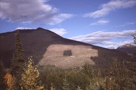
File consists of:

  • David Mills, "Aleza Lake Research Forest Historical Internship Summary" (2 Jan. 2007), 26 p. - In print and original digital .doc file
  • David Mills, "Aleza Lake Forest Experiment Station Socio-Economic Time Line 1905-1937" (2007), 68 p. - In print and original digital .doc file
  • ALRFS employment paperwork for David Mills, the ALRFS Natural Resource History Intern
  • Research notes, including a copy of a map of the town of Aleza Lake in the 1920s
2003.4.3.025 · Dossier · 1987-1989
Fait partie de Kemano Completion Project Dispute Collection

File consists of memoranda from Per Saxvik to Bell-Irving regarding "Fraser River Flow Analysis with Reference to Fish Passage Capacity through the Main Fishways at Hell's Gate". Also includes a "Fraser River Canyon Fish Passage Summary Report (June 1988) Updated October 1989" by Per Saxvik of SEP Engineering.

Fraser River - Boating
2012.13.1.15.37 · Pièce · [1975?]
Fait partie de J. Kent Sedgwick fonds

Image depicts three unknown individuals in a boat on the Fraser River; the man steering the boat is Ray Mueller.

Boating - Starting Down
2012.13.1.15.21 · Pièce · [1975?]
Fait partie de J. Kent Sedgwick fonds

Image depicts a group of people in boats, with Ray Mueller steering one of them, on the Fraser River in the Grand Canyon, B.C.

Cache Walk
2012.13.1.3.035 · Pièce · Oct. 1976
Fait partie de J. Kent Sedgwick fonds

Image depicts a nature trail along the Nechako River at Island Cache looking west with the cutbanks in the background. Map coordinates 53°55'36.2"N 122°45'11.8"W

Cottonwood Island Park Trail
2012.13.1.3.085 · Pièce · [198-?]
Fait partie de J. Kent Sedgwick fonds

Image depicts a couple walking through a nature trail in Cottonwood Island Park. Map coordinates 53°55'23.6"N 122°43'53.8"W

Nechako Cutbanks
2012.13.1.3.090 · Pièce · 12 Oct. 1989
Fait partie de J. Kent Sedgwick fonds

Image depicts the cutbanks on the other side of the Nechako, taken from the nature trail at Island Cache. Map coordinates 53°55'34.6"N 122°45'52.4"W

Nechako Cutbanks Trail
2012.13.1.3.091 · Pièce · 12 Oct. 1989
Fait partie de J. Kent Sedgwick fonds

Image depicts the cutbanks on the other side of the Nechako, taken from the nature trail at Island Cache. Map coordinates 53°55'34.6"N 122°45'52.4"W

Nechako Cutbanks Trail
2012.13.1.3.092 · Pièce · 12 Oct. 1989
Fait partie de J. Kent Sedgwick fonds

Image depicts the cutbanks on the other side of the Nechako, taken from the nature trail at Island Cache. Map coordinates 53°55'34.6"N 122°45'52.4"W

Fort George Park
2012.13.1.3.113 · Pièce · 12 Oct. 1989
Fait partie de J. Kent Sedgwick fonds

Image depicts the Fort George Par, which was renamed Lheidli T'enneh Memorial Park in 2015. Map coordinates 53°54'30.2"N 122°43'57.4"W

Yellowhead Bridge
2012.13.1.3.120 · Pièce · 12 Oct. 1989
Fait partie de J. Kent Sedgwick fonds

Image depicts the Yellowhead Bridge across the Fraser River. Map coordinates 53°54'45.2"N 122°43'27.9"W

Mr. P.G.
2012.13.1.3.122 · Pièce · 12 Oct. 1989
Fait partie de J. Kent Sedgwick fonds

Image depicts Mr. P.G. and the Tourism Information site at the intersection of Highway 16 and 97. Map coordinates 53°53'46.5"N 122°46'00.7"W

Foothills Bridge
2012.13.1.3.123 · Pièce · 12 Oct. 1989
Fait partie de J. Kent Sedgwick fonds

Image depicts the Foothills Bridge over the Nechako river on the Foothills Boulevard in Prince George, B.C. Map coordinates 53°56'52.5"N 122°48'59.9"W

Bear Snow Sculpture
2012.13.1.3.147 · Pièce · Apr. 1999
Fait partie de J. Kent Sedgwick fonds

Image depicts a snow sculpture of a bear, possibly during the Winter City Conference, in Prince George, B.C. Taken at the Prince George Civic Center. Map coordinates 53°54'45.6"N 122°44'59.6"W

Wood Bridge and Snow Sculptures
2012.13.1.3.148 · Pièce · Apr. 1999
Fait partie de J. Kent Sedgwick fonds

Image depicts two snow sculptures near a wooden bridge on an ice rink, possibly during the Winter City Conference, in Prince George, B.C. Taken at the Prince George Civic Center. Map coordinates 53°54'45.6"N 122°44'59.6"W

Fire Place and Couch Snow Sculptures
2012.13.1.3.149 · Pièce · Apr. 1999
Fait partie de J. Kent Sedgwick fonds

Image depicts a snow sculpted fire place and couch on a skating rink, possibly during the Winter City Conference, in Prince George, B.C. Taken at the Prince George Civic Center. Map coordinates 53°54'45.6"N 122°44'59.6"W

Mr. P.G. on Couch Snow Sculpture
2012.13.1.3.150 · Pièce · Apr. 1999
Fait partie de J. Kent Sedgwick fonds

Image depicts a snow sculpture of the Mr. P.G. lounging on a couch, possibly during the Winter City Conference, in Prince George, B.C. Taken at the Prince George Civic Center. Map coordinates 53°54'45.6"N 122°44'59.6"W

Man with Shovel Snow Sculpture
2012.13.1.3.151 · Pièce · Apr. 1999
Fait partie de J. Kent Sedgwick fonds

Image depicts a snow sculpture of a man with a shovel, possibly during the Winter City Conference, in Prince George, B.C. Taken at the Prince George Civic Center. Map coordinates 53°54'45.6"N 122°44'59.6"W

View of Downtown Prince George
2012.13.1.3.156 · Pièce · Nov. 2000
Fait partie de J. Kent Sedgwick fonds

Image depicts downtown Prince George taken from across the Nechako River looking south. Map coordinates 53°56'00.0"N 122°44'29.7"W

Northwood Pulpmill
2012.13.1.3.160 · Pièce · Nov. 2000
Fait partie de J. Kent Sedgwick fonds

Image depicts the Northwood Pulpmill in Prince George, B.C. taken from above the Nechako River looking east. Map coordinates 53°56'00.0"N 122°44'29.7"W

Flooded Area
2012.13.1.87.002 · Pièce · [between 1975 and 1995]
Fait partie de J. Kent Sedgwick fonds

Image depicts a flooded area with an old sawdust pile in the background. Likely near McGregor, B.C.

Sinclair Mills Beehive Burner
2012.13.1.87.005 · Pièce · [between 1975 and 1995]
Fait partie de J. Kent Sedgwick fonds

Image depicts a beehive burner covered in snow in Sinclair Mills, B.C. Map coordinates 54°01'17.4"N 121°40'53.0"W

Logs, Fraser River, and Mountains
2012.13.1.87.013 · Pièce · [between 1975 and 1995]
Fait partie de J. Kent Sedgwick fonds

Image depicts a pile of old logs on the bank of the Fraser River with mountains in the background. In the foreground, a set of railway tracks run through an uncertain location, likely Upper Fraser, B.C.

Sinclair Mills Railway Tracks
2012.13.1.87.014 · Pièce · [between 1975 and 1995]
Fait partie de J. Kent Sedgwick fonds

Image depicts railway tracks and buildings with a beehive burner on the left. The location is likely Sinclair Mills, B.C. Map coordinates 54°01'17.4"N 121°40'53.0"W