Showing 66 results

Archival description
66 results with digital objects Show results with digital objects
2023.2.2.2 · Subseries · 1995-2005
Part of Dr. Paul Sanborn fonds

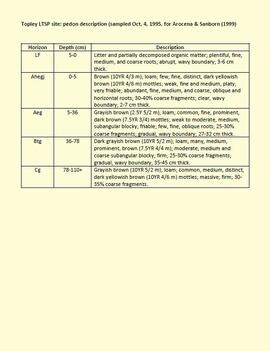
In the mid-1990s, Dr. Paul Sanborn worked with Dr. Lito Arocena of UNBC to assemble and interpret basic physical, chemical, and mineralogical data for typical soils at important long-term forestry research sites in central and northeastern BC. The key results were published as:

J.M. Arocena and P. Sanborn. 1999. Mineralogy and genesis of selected soils and their implications for forest management in central and northeastern British Columbia. Canadian Journal of Soil Science 79: 571-592. https://doi.org/10.4141/S98-07

Nine pedons were involved, with 7 located at the sites of 4 Ministry of Forests Experimental Projects (E.P.), and 2 at the Aleza Lake Research Forest.

2023.2.2.10 · Subseries · 1993-2001
Part of Dr. Paul Sanborn fonds

While at the Ministry of Forests, Dr. Paul Sanborn carried out two retrospective studies which examined soil chemical properties at long-term silvicultural research sites where different vegetation types had been created, either as planned or unplanned experiments. These studies were Experimental Project (EP) 660 and a research project at the Archie Creek site.

2023.2.2.5 · Subseries · 1991-2023, predominant 2004
Part of Dr. Paul Sanborn fonds

The Lost Chicken Mine, a placer gold mine in eastern Alaska, approximately 120 km west of Dawson City, Yukon, is an important fossil locality for the late Pliocene (approximately 2.5 – 3.0 million years ago). A comprehensive account of the stratigraphy and paleontology of this site was given by:
Matthews, J.V., Jr., J.A. Westgate, L. Ovenden, L.D. Carter, and T. Fouch. 2003. Stratigraphy, fossils, and age of sediments at the upper pit of the Lost Chicken gold mine: new information on the late Pliocene environment of east central Alaska. Quaternary Research 60: 9-18. https://doi.org/10.1016/S0033-5894(03)00087-5

Dr. Paul Sanborn visited the site on July 20, 2004, as part of a group led by Duane Froese (Professor, University of Alberta). The group concentrated on a single exposure (~ 2 m thick) straddling the Lost Chicken tephra, a volcanic ash bed (2.9 ± 0.4 myr) which is a major stratigraphic marker at the site. Sanborn described, photographed, and sampled this exposure, and obtained a basic set of characterization data. Intact samples were collected but thin sections were never produced.

2023.2.2.1.1.1 · Item · 28 Feb. 1990
Part of Dr. Paul Sanborn fonds

During a year away from studies in 1987-88, Dr. Paul Sanborn developed a successful grant proposal to the Science Council of BC (SCBC) to pursue a postdoctoral project with Dr. Tim Ballard in relation to sulphur-deficient soils in BC and prescribed fire. This project built on an existing broadcast burning study conducted by Macmillan Bloedel Ltd. near Port Alberni on Vancouver Island, led by Bill Beese (later at Vancouver Island University). Dr. Sanborn's work addressed sulphur forms and amounts in the soils at these sites, and the chemical processes influencing sulphur availability in relation to prescribed fire.

Only one part of this work was eventually published:
Sanborn, P.T. and T.M. Ballard. 1991. Combustion losses of sulphur from conifer foliage: Implications of chemical form and soil nitrogen status. Biogeochemistry 12: 129–134. https://doi.org/10.1007/BF00001810

The remainder of the work was documented in this Project Completion Report to SCBC, dated February 28, 1990, and entitled "Effects of Prescribed Fire on Sulphur in Forest Soils".

2006.18.1.01 · File · 1990-1996
Part of Aleza Lake Research Forest Society fonds

File consists of:

  • "A Summary of Historical Orders-in-Council affecting the Aleza Lake Forest Reserve", Mike Jull, 18 Dec. 1996
  • Photocopied memorandum from F.S. McKinnon regarding "Transfer of Aleza Lake to D.F. Prince George", 9 Sept. 1963
  • Photocopied 1928 article by P.M. Barr from Forestry Chronicle 4(3) entitled "The Aleza Lake Experiment Station: Its Development and Purpose"
  • "A Brief History of the Aleza Lake Experiment Station", [Tim Decie, 1981?]
  • Contact information for living relatives of Percy Barr, as of 1990
  • Photocopy of 1930 article by Percy Barr entitled "Spruce Reproduction in British Columbia"
  • Photocopy of records from BC Archives from a visit by Harry Coates from the file GR 1348 "The Young Mens Forestry Training Program"
  • Photocopy of excerpt regarding "Amanita Lake/Diameter Limit Logging"
  • Various small-scale maps and charts regarding Aleza Lake
  • "Aleza Lake Research Forest Information Session Notes with Mike Jull, Manager of ALRF"
Forest soil sulphur research
2023.2.2.1 · Subseries · 1988-2011
Part of Dr. Paul Sanborn fonds

Forest soil sulphur research was a continuing interest for Dr. Paul Sanborn for more than 30 years, beginning at UBC in the mid-1980s when he took a graduate course in Forest Soils from Dr. Tim Ballard. Among the things that he learned was that soils in much of BC were deficient in sulphur (S). Simultaneously, he became aware of the large amount of research on prescribed fire in BC forests, with broadcast burning being the main method of site preparation across much of the province at that time.

Sanborn undertook various projects in this area of research:

  1. UBC Postdoctoral Project on effects of prescribed fire on sulphur in forest soils (1988-90)
  2. Cluculz retrospective study (E.P. 886.10) with the BC Ministry of Forests and UNBC
  3. Sulphur stable isotope tracer study (E.P. 886.15) with the BC Ministry of Forests and UNBC
2023.2.2.6 · Subseries · 1983-2010
Part of Dr. Paul Sanborn fonds

During the 1980s, Agriculture Canada pedologists Scott Smith (retired from Summerland Research Station, formerly based in Whitehorse) and Charles Tarnocai (retired from Central Experimental Farm, Ottawa) had a large field program which addressed the trends in soil development in the central Yukon. Across this region, particularly between Whitehorse and Dawson City, the land surfaces and surficial deposits vary greatly in age due to the differing extents of glaciations over the past ~2 million years.

This work built on a pioneering study from the previous decade:
Foscolos, A.E., N.W. Rutter, and O.L. Hughes. 1977. The use of pedological studies in interpreting the Quaternary history of central Yukon Territory. Bulletin 271. Geological Survey of Canada, Ottawa. 48 p. https://doi.org/10.4095/103066

Tarnocai and Smith presented their results in two publications:
C. A. S. Smith, C. Tarnocai, and O. L. Hughes. 1986. Pedological investigations of Pleistocene glacial drift surfaces in the central Yukon. Géographie physique et Quaternaire, 40 (1): 29–37. https://doi.org/10.7202/032620ar
Tarnocai, C. and C. A. S. Smith. 1989. Micromorphology and development of some central Yukon paleosols, Canada. Geoderma 45 (2): 145-162. https://doi.org/10.1016/0016-7061(89)90047-5

Tarnocai and Smith shared the unpublished data and soil samples from this work with Dr. Paul Sanborn, and this resulted in a student project published as:
Daviel, E., P. Sanborn, C. Tarnocai, and C.A.A. Smith. 2011.Clay mineralogy and chemical properties of argillic horizons in central Yukon paleosols. Canadian Journal of Soil Science 91: 83-93. https://doi.org/10.4141/cjss10067

2006.18.5.18 · File · 1974
Part of Aleza Lake Research Forest Society fonds

File is a Resource Folio of maps and accompanying information created by Northwood Pulp & Timber regarding Timber Sale Harvesting Licence A01847, Willow River Block, Willow River P.S.Y.U. Includes maps that depict ungulates, waterfowl, recreation areas, special influence areas, and timber types. Most of the sheets have a duplicate, some with very slight variations. The following maps are supposed to be included in the but were missing upon arrival at the Archives: fish & topography, cutting permits & roads, and soils.

2006.18.6.01 · File · [196-?]
Part of Aleza Lake Research Forest Society fonds

Photographs are panoramas taken from the Churchill BC Forest Service Lookout, located at latitude 54°04' and longitude 122°16'. The photographs were bound together and include a transparent grid that was intended to be used for locating forest fires.