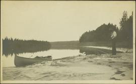
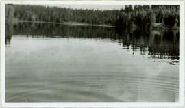
Photograph depicts three men standing with oars in small boat, forest slash at their feet. More slash lies in foreground behind bushes and plants on swampy shore. Trees in background. These men are believed to be members of the Bourchier forestry crew.
Photograph depicts an empty canoe floating directly in front of small white tents on opposite shore. Forest trees in background.
Photograph depicts one woman with her back turned, and four men standing on scow next to chairs and table adorned with food. Trees on shore in background. Handwritten annotation on recto of photograph reads: "Bourchier Scow".
Photograph depicts settlement across frozen lake. Trees cross midground, mountains stand in background. Handwritten annotation on verso of photograph reads: "Distant view of Tete Jaune B.C.", on recto of photograph: "I marked about where you loaded your boat the telephone pole is down the road toward 53. Tete Jaune Mile 52."
Photograph depicts four men and small cart standing in street, lines of log buildings on either side. Tents can be seen at end of left side of street. First building on left is larger, with the sign "STOPPING PLACE". Trees cross midground, mountains stand in background. Handwritten annotation on verso of photograph reads: "Tete Jaune Cache. B.C."
Tree branches in right foreground, and forest above banks on opposite shore in background.
Photograph depicts a train and long building on high level of river bank. Fraser river in foreground, forest trees on shore in background.
Photograph depicts men on river scow in distance. Rocks in foreground, trees and cliffs on opposite shore in background. Handwritten annotation on verso of photograph: "Scow in Upper Grand Canon. Fraser River. B.C.."
Photograph depicts two men believed to be North-West Mounted Police officers standing on either side of white packhorse. Forest and mountains in background. Photograph may have been taken in Vanderhoof, B.C.
Officers are mounted on three horses standing in water. Fifth horse stands on right, trees on shore in background. Handwritten annotation on recto of photograph: "Jas Tracey, Vanderhoof. Srg. Birch."
Photograph depicts Bill and canoe on sandy shore, river and opposite shore in background. Handwritten annotation on recto of photograph: "Billy Barnett at Giscome Portage."
Photograph depicts men on river boat and small canoe floating just off shore. Men sit and stand on shore among square bales and large cut lumber. Forest in background. Handwritten annotations on recto of photograph: "Fort Fraser wooding up at Giscome Portage", "Chilco at Giscome Portage".
Fred and Alan are being pushed in wheelbarrow by a woman wearing a blouse, dress pants, and sunglasses. Typed annotation on recto of photograph: "This is 'Mac' - she is a young woman." This woman is speculated to be Tom Taylor's wife Marion. They stand in a field with a car behind them. A forest and body of water can be see in background, as well as the opposite shore.
Mountains visible in background.
A woman stands in distance on a road with high snowbanks and trees on either side. A dog can be seen in foreground, facing woman. A fence and other structures stand in midground. Tree-covered slope in background.
Photograph depicts a street scent at the corner of Laselle and Second St. in Fort George. A wagon is visible in the dirt road and wooden buildings cross the mid ground. Three unidentified men sit on the boardwalk outside Rigg's Restaurant while one man stands in the doorway of The White Laundry.
Photograph features a sign in the middle of a field at the Royal Canadian Air Force base in Whitehorse, YT that reads: "Taking Photographs Prohibited". Handwritten photo album caption below this photo reads: "Our Authority". See also items 2006.20.12.39 & 2006.20.12.43.
Royal Canadian Air ForceHandwritten photo album caption below this photo reads: "Waiting for the Plane at 'Watson'" Photograph depicts unidentified man standing on ice and holding a fish. The ice in the area behind him has been broken, creating a small pond in the frozen lake. Second man sitting behind pond area. Trees on opposite shore in background.
Royal Canadian Air ForceHandwritten photo album caption below this photo reads: "Above the Rockies at 12 000 feet." Photograph depicts the Rocky Mountains from a distance. As the photograph was taken from the inside of an airplane, the plane's wing tip can be seen on the far right of the image. A sun circle is also visible in the top center.
Royal Canadian Air ForceView of ripples in lake. Forest on opposite shore is reflected in water. It is believed this photograph was taken at Summit Lake, B.C.
Handwritten caption above this photo reads: "Plane on Sumit Lake." Logs can be seen floating on water in foreground, as well as trees on opposite shore in background. The seaplane has the letters "CF-ATF" on its side.
Photograph depicts the steep slope of man-made embankment, forest in background at bottom of slope. Small twigs and pant leg of unidentified individual in foreground.
Photograph depicts the steep slope of man-made embankment. Forest in background, level excavated ground in foreground.
Photograph depicts large square model of the new mill building that was built at the Cassiar plant site in 1970. Model is displayed outdoors on a platform that stands on four saw horses. Machinery modeled inside the structure is colour-coded. Plant buildings and mountains in background.
Photograph depicts buildings near West Peak of Cassiar mine. Haul trucks parked near old mine garage in background, new mine garage and unknown buildings in foreground. Mine valley crosses midground, expansive western mountain range in background.
Photograph depicts unknown men driving bulldozers on edge of mine area at high elevation. Dozers are Internationals, model TD24 (manufactured between 1947 and 1955). Valley and mountain range in background.
Photograph depicts mine area at Cassiar, crushing plant visible on left. Various mine buildings visible midground. Blasthole drills, shovels, dozers, and dump trucks can be seen on bench in foreground at 6430 elevation. Handwritten annotations on recto of photograph: "6"; "View looking NW from top of S. peak 6790 elev. on 6430 stripping bench on it and 6050 ore bench further down on left."; "July 1961".
Photograph depicts men standing near two Atlas Copco Drillmasters (blasthole drills). These are precision hammer drills which had their own power source. Large bags of ammonium nitrate in foreground, mountainside in background. The men depicted here were likely members of the explosive crew. It is believed that this photo was taken on the North ridge, near the cirque dump. Handwritten annotation on verso of photograph: "1961".
Photograph depicts a man wearing a hard hat preparing long narrow bags of explosive material. Large bags of ammonium nitrate in right foreground, mountains in background. Handwritten annotation on verso of photograph: "1961".
Photograph depicts crawler cable shovel and dump truck in excavation area of mine. Handwritten annotation on verso of photograph: "1961".
Photograph depicts various buildings in plantsite, vehicles and electricity lines throughout. Equipment garage stands in left background behind tank farm, carpenter shop in right background, machine and electrical shop in building semi-visible on far right. Mine road can be seen at foot of mountain in background. Handwritten annotation on verso of photograph: "1961".
Photograph depicts a gravel road passing under crossing. Sign posted to pole reads "CAUTION TRAMLINE CROSSING CAUTION AVIOD PASSING UNDER MOVING BUCKETS". Garage stands in left midground, mountains in background. Handwritten annotation on verso of photograph: "1961".
Photograph depicts long wood building speculated to be the Community Centre at Cassiar, B.C. Sports net stands in right foreground. Flag pole, barrel, and stand of trees can be seen in front of building. Mountains in background. Handwritten annotation on verso of photograph: "1961".
Photograph depicts four houses in line behind trees and steel drums. Road in foreground, mountains in background. Handwritten annotation on verso of photograph: "1961".
Item is a photograph of the construction of the WAC Bennett Dam.
Item is a photograph of the coffer dam built to isolate the construction site for the W.A.C. Bennett Dam.
Item is a photograph of a self-dumping log barge in action.
Item is a photograph of a forested area with a partially frozen river, exact location unknown.
Item is a photograph of a woman working in a field.
View of summit lake from above, many small tree-covered islands and peninsulas visible. Handwritten caption beside this photo reads: "Sumit Lake".
Photograph depicts tree shadows halfway up the steep slope of man-made embankment, forest in background. Tracks made my machinery are visible in dirt of the cut.
Photograph depicts Knox McCusker holding a fish outside a survey camp tent. Caption on verso reads: “Well say! Betty! A Toad River Indian”. It is believed this photo was taken at Tuchadi Lake.
Photograph is a group photo of five men standing around a tent in a wintery wooded landscape; Knox McCusker stands first man from the right, with hands in pockets. Caption on verso reads: “Youthful K.F.McC. on the right. Probably Northern Ontario or Manitoba”.
Photograph depicts bridge built with wooden planks and poles, with triangles built into its frame. Water rapids in foreground, opposite shore in background behind bridge. This is speculated to be one of the bridges that crossed the Hagwilget Canyon on the Bulkey River since 1859, five kilometres from its confluence with the Skeena River. See items 2009.5.1.69 - 2009.5.1.71.
Handwritten annotation on recto of photograph: "Omineca Dist Walcott Suspension Bridge West Approach - looking East May 26 - 1932". Photograph depicts two white horses pulling a wagon in front of Walcott bridge. This bridge was moved from its original location in the Hagwilget Canyon, downstream from Walcott on the Bulkley River. It is a pedestrian bridge at the time of this photograph, though it was originally used by motor vehicles. Dirt road leading to bridge in foreground, with lumber and brush piles on either side. Trees and hills on opposite shore in background.
Photograph depicts a man cooking over campfire, log building and forest in background.
Photograph depicts man smoking pipe in area believed to be a mining location, sandy cliffs in background.
Photograph depicts three men wearing suits and ties, posed in front of car in gravel area believed to be at a mining location. Hauling truck crosses road in midground, cliffs and hills in background.
Photograph depicts an unidentified man mining in rocky area, trees and hills in background. Handwritten annotations on verso of photograph: "PLACER MINER WSHING FOR GOLD FINDLAY RIVER BC", "PHOTO WWW".