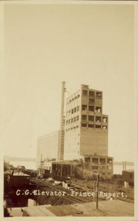
Showing 6040 results

Archival description
2849 results with digital objects Show results with digital objects
2023.2.2.13.2.07 · Item · 8 Jul. 2007
Part of Dr. Paul Sanborn fonds

This image is part of the outbound sequence of aerial images obtained on the helicopter flight to the Klutlan Glacier study site. The sequence starts from the base camp at the White River crossing on the Alaska Highway and heads south, to a point just upvalley of the debris-covered terminus (approx. 10-15 km from Alaska border), and turning back north to the landing spot on the Generc River floodplain close to the study site (see Fig. 1 in paper).

Cheakamus River
2014.10.1.145 · Item · 1911
Part of Arthur Holland Land Surveying Collection

Photograph depicts three men standing in front of a log cabin. Two men hold fishing rods and each of these men hold a freshly caught fish. The third man stand to the side with a loaded back pack. Two men smoke pipes.

2003.4.3.035 · File · 1987-1994
Part of Kemano Completion Project Dispute Collection

File consists predominantly of faxed correspondence and documents from the Cheslatta Carrier Nation and the Carrier Sekani Tribal Council. These documents include copies of newspaper clippings, news releases, publicity material regarding Cheslatta Band's position on the Kemano Completion Project, briefing notes, documents written by Dana Wagg, correspondence from Alcan to the Band, and copies of released Department of Fisheries and Oceans memoranda. Also includes "The Story of the Surrender of the Cheslatta Reserves on April 21, 1952" by Mike Robertson; a copy of a "Proposal for an Agreement between the Government Commission of the Gitksan Wet'suwet'en People and the Vera Corporation regarding the Nanika River Project" of November 13, 1991; and a 1984 paper by Megan Swail entitled "The Kemano Completion Project: Selected Legal Issues".

2003.4.1.34 · File · 1991-1993
Part of Kemano Completion Project Dispute Collection

File consists of correspondence and reports from John Hummel and Dana Wagg, Cheslatta Band researchers. Also includes clippings; anti-Kemano propaganda material; copies of Alcan correspondence; "The Story of the Surrender of the Cheslatta Reserves on April 21, 1952"; "Chronology of the Cheslatta Lake Flooding and Subsequent Surrender, Moving and Relocation of the Cheslatta Indian Band as Gleaned from Original Letters, Documents, Interviews, and other Printed and Written Material" compiled by Mike Robertson in 1991; "Kemano 2 Update" report by Dana Wagg; and "Kemanogate: Secret DFO probe quashed, Tapes destroyed" by Dana Wagg.

2011.3.1.18 · Item · 29 February 1908
Part of North Coast & Central BC Postcard Collection

Photograph of a person chopping down firewood in a forest. Printed annotation on recto reads: "Chopping Fire-Wood, near Fort Simpson, 1118." Handwritten annotation on verso reads: "55 Avenell Road, N. 29-2-'08 I wanted to write you a letter, but have had suck a lot to do, I find there isn't time before Prayer meeting; and as I haven't been able to go to P.M. for the last three weeks, I am sure you won't mind just for this once. Here is a p.c. of Canada which I promised you; don't you think it is pretty? Things are going on pretty well now; mother is better & Daisy- well, I never saw SO much improvement in anyone in one short week. As much love as if this were the longest letter I have ever written you, from Effie." Postcard is addressed to: "Mis J.G. Grafton "Belmont" Tividale Road, Tipton, Staffs." Verso is affixed with a British halfpenny green stamp and canceled with a postmark that reads: "Highbury S.O. 915 PM Fe 29 08."

2006.18.6.01 · File · [196-?]
Part of Aleza Lake Research Forest Society fonds

Photographs are panoramas taken from the Churchill BC Forest Service Lookout, located at latitude 54°04' and longitude 122°16'. The photographs were bound together and include a transparent grid that was intended to be used for locating forest fires.