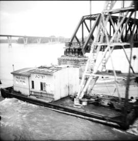
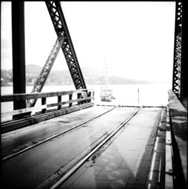
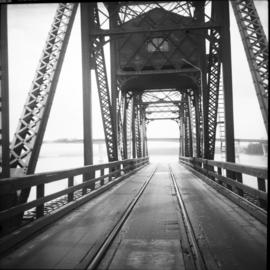
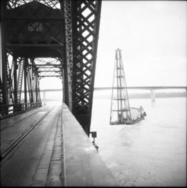
Photograph depicts the CPR Mission Bridge on the Huntingdon branch. The photo was taken from the open swing span looking downstream, with a tug and derrick (Fraser River Pile Driving Co.) fast disappearing downstream. The new road bridge in the background is about to be opened in late June 1973.
Photograph depicts the CPR Mission Bride on the Huntingdon branch. The photo was taken from the open swing, and shows a tug and derrick passing swiftly downstream in the north channel of the opening. The span opens about every 2 or 3 days for river traffic.
Photograph depicts the CPR Mission Bridge on the Huntingdon branch. The span opened to allow downstream passage of a tug and derrick, which passed at about 6 to 8 knots because of the freshet. Tow started at federal wharf at Mission City. The span opens for river traffic every 2 or 3 days. The view is looking east and upstream.
Photograph depicts the CPR Mission Bridge on the Huntingdon branch. The swing span is in an open position and the view is looking west and downstream. A new road bridge to be opened within the month is in the background. The bridge cabin holds a gas engine that turns the span in about 60 seconds.
Photograph depicts the West Summerland CPR station in the Okanagan. The station often was used but not permanently manned. It was located at mile 9.5 from Penticton. The view is looking south.
Photograph depicts the Penticton CPR depot. The view is looking northwest.
Photograph depicts the CPR Faulder depot on the Kettle Valley Railway. It is located at mile 15.5 from Penticton, on the Princeton Subdivision.
Photograph depicts the CPR line at Arawana, 5 miles northeast of Penticton and at mile 125.7 on the Carmi Subdivision. The photo shows the ruins of the station house and Okanagan Lake in the background. The passing loop in the foreground has been disconnected and partially dismantled. The rear track was used once or twice weekly by the way freight train between Penticton and Midway. The view is looking west.
File consists of documentary photographs taken by David Davies of various houses in British Columbia.
Photograph depicts an abandoned ranch house, southeast of Rock Creek, north of an abandoned GNR grade, and about a mile north of an international boundary.
Photograph depicts a house that had been pushed on its side by a bulldozer.
Photograph depicts a house that provided an example of the few surviving homes left on Beach Ave.
Photograph depicts one of the surviving houses on Beach Ave, Vancouver, between Gilford and Chilco.
Photograph depicts a house that had a "sold" notice on it and was partly demolished. Up to the date the photograph was captured, this block on Beach Ave. was the sole remaining one to have only houses on it, as opposed to a mixture of houses and apartment blocks, or blocks only.
Photograph depicts a house that was probably built in 1890-1900. It had just been demolished.
Photograph depicts a house on the southern edge of Chinatown.
Photograph depicts a two story log house located on Fiva Creek, beside east Kettle River.
Photograph depicts the Great Northern Railway station on Main Street, Vancouver being demolished.
Photograph depicts the Wrinch Memorial Hospital. It held 54 beds and was founded by Dr. Winch for the benefit of the local First Nations population.
Photograph depicts Vancouver City College, formerly King Edward Secondary School.
Photograph depicts a church on River Road, Whonnock, Maple Ridge.
Photograph depicts an Indian Roman Catholic church at the mouth of Anderson Lake. No services were held anymore. It was externally restored in 1968 by the white people of the village, while the Natives did the interior. Unfortunatley, there was no work done on the interior as of the date the photograph was captured.
Photograph depicts a Ukranian Greek Orthodox church on the outskirts of Mission.
Photograph depicts the completely rebuilt drug store in Barkerville based on historical sketches and photos.
Photograph depicts a building that was believed to have had many usess, its last being a fish store.
Photograph depicts the one and only service station that was in Trout Lake City. It had manual pumps as there was no distributed electricity in the village.
Photograph taken in the ghost town of Ferguson. About 8 deserted buildings remained, of which two appeared to be used as summer cabins. This building was the Lardeau Hotel.
Photograph depicts the Deroche post office that was well patronised for mail and newspaper distribution.
Photograph depicts a Canadian Customs House. The border crossing was only open between 8:00 a.m. and 5:00 p.m. daily.
Photograph depicts one of various old lead and zinc mine buildings. Behind this building, on the foreshore, were a few men working on the reclamation of tailings and waste from the mine that was dumped in Kootenay Lake.
Photograph depicts a Public Weigh Scale that was operated in Vancouver, on Main Street, opposite the CN Depot.
Photograph depicts Pioneer Sash and Door Company Ltd. Davies suggests that it may have been the same as S.C. Smith Ltd., which commenced operating in Vernon in 1883. In the early days, products were verandah posters, balusters, and fancy trim. Most products were sent to the U.S. Most of the fancy trim in early north Okanagan homes came from this plant. In 1972, its main output was cedar panelling for Florida.
Photograph depicts the Tofino Airport. It was a former wartime RCAF base built in 1942 for anti-Japanese air patrols. It was now a D.O.T controlled airport.
Photograph depicts an unknown building in B.C.
Photograph depicts a disused cabin that was perhaps abandoned in the late 1950's.
Photograph depicts a new log house that was under construction.
Photograph depicts a deserted cabin on the Indian Reserve above the PGE track at the northwest corner of Seton Lake. It probably had been occupied up until the last 5 years.
File consists of documentary photographs taken by David Davies of agricultural buildings in British Columbia.
Photograph depicts "Six Mile House Stable" on the west side of Okanagan Lake.
Photograph depicts a boathouse at an unknown location.
Photograph depicts a derelict barn displaying frame construction.
Photograph depicts the same person who owned the service station building electric generator house in Trout Lake. He also built an undershot water wheel that was driven by Lardeau Creek.
Photograph depicts a pump house on the Island Highway, north of Qualicum Beach, Vancouver Island.
Photograph depicts a log cabin with a sod roof that was used as a cow shelter on Dot Ranch. The ranch was probably built by pioneers pior to 1900.
Photograph depicts a home on 390 Franklin St., Nanaimo, B.C. on Vancouver Island.
Photograph depicts about the only brick house in North Wellington, Nanaimo. It was possibly built about 1860-1870 when coal working first commenced.
Photograph depicts what is believed to be the only remaining "summer cottage" on Beach Ave. in English Bay.
Photograph depicts a barn advertised for rent on Liverpool Rd. in South Westminster. Barn later half demolished on April 17, 1966.
Photograph depicts an old house on 148th St. in north Surrey, about half a mile southwest of the south end of the Port Mann Bridge.
Photograph depicts a former Sailor's Home at the southeast corner of the intersection at Alexander St. and Jackson St. in Vancouver, B.C.