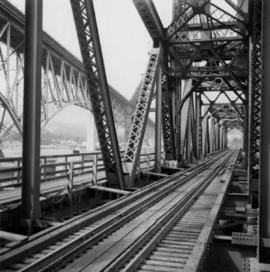
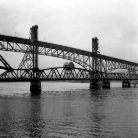
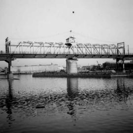
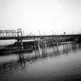
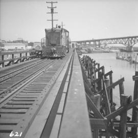
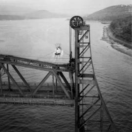
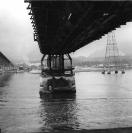
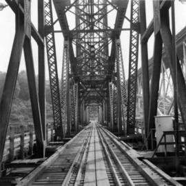
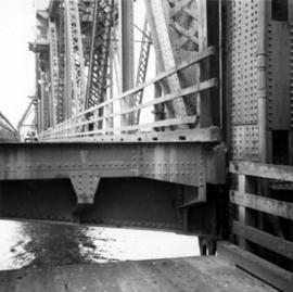
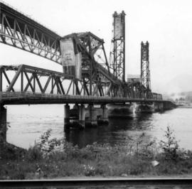
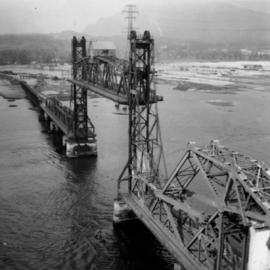
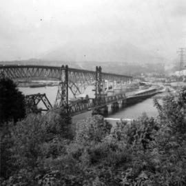
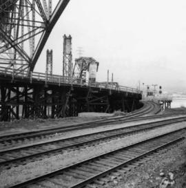
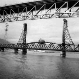
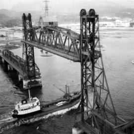
Photograph depicts the Second Narrows Railway Bridge in Vancouver, BC, as a coastal tanker going upstream to a refinery passes beneath it.
Photograph depicts the Second Narrows Railway Bridge in Vancouver, BC, as the lifting span is starting to drop. The view is looking east towards Capitol Hill and Berry Point.
Photograph depicts the underside of the lifting span of the Second Narrows Railway Bridge in Vancouver, BCView is from the south, fixed side.
Photograph depicts the Second Narrows Railway Bridge in Vancouver, BC; view from the lifting span looking south.
Photograph depicts the lifting span of the Second Narrows Bridge with a motor car on the west roadway, as the span is about to close to its normal, flush position.
Photograph depicts the Second Narrows Railway Bridge in Vancouver, BC, from a view on the lifting span looking north.
Photograph depicts the Second Narrows Railway Bridge in Vancouver, BCfrom the south east shore.
Photograph depicts a trestle bridge for road traffic leading to the Second Narrows Bridge in Vancouver, BCThe shot is taken from the south bank.
Photograph depicts the Cambie St. Bridge in Vancouver, BC, looking east and showing the central swing span.
Photograph depicts a home located at 1459 Robson St., at the northeastern intersection of Robson and Nicola, in Vancouver B.C.
Photograph depicts Hamilton St. in Vancouver, looking northeast.
Photograph depicts a former C.P.R. connection between the False Creek yards and the south side of Vancouver harbour on West Pender St. in Vancouver, B.C. This spur used daily to get cars into the B.C. Electric Rail yard at the Georgia Viaduct from the C.P.R. False Creek yards.
Photograph depicts Mainland St. in Vancouver, B.C. , looking northeast with Helmken St. intersecting.
Photograph depicts a fire hall for fire float VFD "J.H. Carlisle" at False Creek. It is on the north shore and in line with Willow St., Vancouver.
Photograph depicts the False Creek Trestle bridge open and the Granville Bridge looking east.
Photograph depicts the piers of the south tower on the Lions Gate Bridge in Vancouver, BC
Photograph depicts the Lions Gate Bridge on west side looking south from the shore of North Vancouver, BC
Photograph depicts the Second Narrows railway bridge in Vancouver from the south bank. The bascule does not move.
Photograph depicts the north side lifting tower of the Second Narrows railway bridge in Vancouver, BC
Photograph depicts the Second Narrows Railway Bridge in Vancouver, BCwith the lifting span up.
Photograph depicts the road and rail bridges at Second Narrows, Vancouver B.C. The photograph was taken from Boundary Rd. looking north.
Photograph depicts the rail approach to the Second Narrows Railway Bridge in Vancouver, BCThe shot taken on CPR trackage and from underneath the road bridge on the south bank.
Photograph depicts the Second Narrows Railway Bridge, looking east.
Photograph depicts the road bridge crossing the south section of the north arm of the Fraser River at Fraser St. The view is from the north bank of Lulu Island.
Photograph depicts the Fraser St. road bridge over the north section of the north arm of the Fraser River, looking north from Mitchell Island to Vancouver, BC
Photograph depicts the Cambie St. Bridge in Vancouver, BC, looking southeast and showing the southern fixed span on the bridge.
Photograph depicts the building for the Vancouver Supply Company located at 25 Alexander St. in Vancouver, B.C. It is at the center of the old downtown and may have been a former fire hall.
Photograph depicts the former C.P.R. route connecting existing False Creek rail yards and the Burrard shoreline main line. The view is looking southwest from the intersection of Powell St. (in foreground) and Columbia St. (not seen) in Vancouver.
Photograph depicts the Grand Central Hotel at the intersection of Marpole Ave and Hudson St. in south Vancouver. The hotel was built in 1912 by J.J. Graver and run from 1913-1915. It re-opened in 1920 as a home for incurables (veterans). In 1937 it became the provincial infirmary and closed in May 1965.
Photograph depicts a corner building on Chilco and West Georgia St. facing Stanley Park in Vancouver, B.C. The view is looking east across Chilco St.
Photograph depicts the site of a former C.P.R. connection between the mainline into Vancouver and False Creek yards at West Pender St. In Vancouver. The rails are not used but still appear in the street and on the parking lot on the far side. Another parallel set of tracks 30 yards to the east are in daily use.
Photograph depicts East Pender St., looking west towards the Vancouver Sun newspaper office near Abbot St. in Vancouver, B.C.
Photograph depicts house at #1053 Beach Ave. in Vancouver, B.C. Dan Davies was a resident at one time.
Photograph depicts Beach Ave. in Vancouver, with the photo taken near the swimming pool and looking west. Photo was taken after a storm.
Photograph depicts home at #1053 Beach Ave., which is now fully demolished.
Photograph depicts a general view of Coal Harbour in Vancouver, looking southeast and south with Marine Building (downtown) on extreme left and Stanley Park (unseen) at extreme right.
Photograph depicts former tram tracks, looking north from the intersection at Campbell Ave and east Georgia St. in Vancouver, BC
Photograph depicts a West Coast Railway Association locomotive and car at a C.N.R. station in Vancouver. The trackage actually belongs to a demolished Great Northern Railway Station.
Photograph depicts a C.P.R. wrecking train unit at Vancouver station.
Photograph depicts a B.C. Electric Railway locomotive #902 and boxcar entering the Kitsilano yards and crossing 2nd Ave., near Fir St. in Vancouver.
Photograph depicts a B.C. Electric Railway trolley electric locomotive #960, in freight yard below the Georgia Viaduct in Vancouver.
Photograph depicts a B.C. Electric Railway locomotive #902 crossing the False Creek trestle, travelling north.
Photograph depicts the Canadian National Railway (CN) main line from the Vancouver depot. The view is looking east, down from the bridge carrying Clark Dr.
Photograph depicts the notice on the outer door of the Great Northern Railway depot in Vancouver.
Photograph depicts Vancouver Fireboat #2 having its hull sandblasted in a dry dock at the Burrard Shipyard & Marine Ways Ltd. at 1729 West Georgia St., Vancouver.
Photograph depicts the tugboat "Island Sovereign" moored at a dock in North Vancouver, 200 yards west of the Burrard Dry Dock, 2 days in service after refit.
Photograph depicts a ship the "Laurier", which may have been a Fisheries Protection Vessel, at the Federal Immigration Dock in Vancouver.
Photograph depicts a new Canadian Navy Oceanographic vessel at C.P.R. B Pier (east side) in Vancouver.
Photograph depicts the H.M.C.S. Beacon Hill at English Bay in Vancouver during the maritime festival.