2020.4.7.022
·
Item
·
Dec. 2005
Part of G. Gary Runka fonds
168 results with digital objects
Show results with digital objects
2006.18.5.68
·
Item
·
15 Jan. 2001
Part of Aleza Lake Research Forest Society fonds
Item is a British Columbia Forest Cover Map, serial number 093J010. Includes full format forest cover labels.
2006.18
·
Fonds
·
2001-2019
The Aleza Lake Research Forest Society (ALRFS) records encompass material that was created or collected by the Society over its existence (2001-present). Records created by the ALRFS consist of administrative and operational records, as well as publications from the Society. Collected records include historical records relating to the Aleza Lake Experiment Forest gifted to the Society or its members. These include maps, photographs, reference material, and documents. Members and associates of the ALRFS also documented the history of the forest through the creation of oral history recordings and written histories such as John Revel's "Devil's Club, Black Flies, and Snowshoes".
The fonds includes a significant amount of reproduced archival material about Aleza Lake from other institutions, such as BC Archives, the Canadian Forest Service, and the BC Forest Service. Many of these reproductions were created as part of the 2006 ALRFS Natural Resources History Internship in an effort to compile the history of the research forest.
Also included are cartographic and photographic materials that depict the Aleza Lake Research Forest and surrounding areas.
2006.18.5.67
·
Item
·
5 Oct. 2000
Part of Aleza Lake Research Forest Society fonds
Item is a British Columbia Forest Cover Map, serial number 093I001. Includes full format forest cover labels.
2000.23.1.041.1
·
Item
·
2000
Part of Audrey Smedley L'Heureux fonds
This Slocan Group forestry development plan highlights contributing obstacles to the development like the Pine Beetle infestation.
2023.2.2.9.1
·
Item
·
22 June 2000
Part of Dr. Paul Sanborn fonds
Map depicts range reference area exclosure locations for livestock and wildlife in the Fort St. John Forest District.

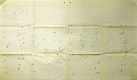
2007.1.45.18
·
File
·
1998
Part of Aleza Lake Research Forest fonds
File contains information, including diagrams, measurement charts, and a map, for experimental plot 118.

2007.1.45.10
·
File
·
1998
Part of Aleza Lake Research Forest fonds
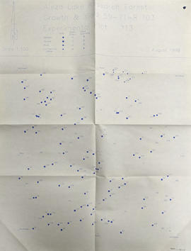
File contains information, including diagrams, measurement charts, and a map, for experimental plot 103.
2007.1.45.19
·
File
·
1998
Part of Aleza Lake Research Forest fonds
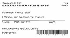
File contains information, including diagrams, measurement charts, and a map, for experimental plot 119.

2007.1.45.15
·
File
·
1998
Part of Aleza Lake Research Forest fonds
File contains information, including diagrams, measurement charts, and a map, for experimental plot 115.

2007.1.45.17
·
File
·
1998
Part of Aleza Lake Research Forest fonds
File contains information, including diagrams, measurement charts, and a map, for experimental plot 117.
2007.1.45.24
·
File
·
1998
Part of Aleza Lake Research Forest fonds
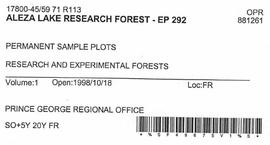
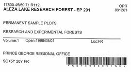
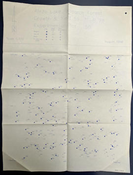
File contains information, including diagrams, measurement charts, and a map, for experimental plot 292.

2007.1.45.08
·
File
·
1998
Part of Aleza Lake Research Forest fonds
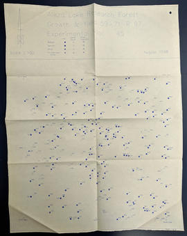
File contains information, including diagrams, measurement charts, and a map, for experimental plot 45.

2007.1.45.11.1
·
Item
·
Aug. 1998
Part of Aleza Lake Research Forest fonds

2007.1.45.12.1
·
Item
·
Aug. 1998
Part of Aleza Lake Research Forest fonds

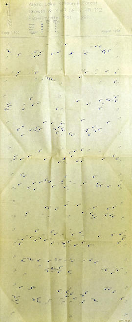
2007.1.45.13
·
File
·
1998
Part of Aleza Lake Research Forest fonds
File contains information, including diagrams, measurement charts, and a map, for experimental plot 112.

2007.1.45.15.1
·
Item
·
Aug. 1998
Part of Aleza Lake Research Forest fonds

2007.1.45.17.1
·
Item
·
Aug. 1998
Part of Aleza Lake Research Forest fonds

2007.1.45.10.1
·
Item
·
Aug. 1998
Part of Aleza Lake Research Forest fonds

2007.1.45.11
·
File
·
1998
Part of Aleza Lake Research Forest fonds
File contains information, including diagrams, measurement charts, and a map, for experimental plot 106.

2007.1.45.12
·
File
·
1998
Part of Aleza Lake Research Forest fonds
File contains information, including diagrams, measurement charts, and a map, for experimental plot 107.

2007.1.45.16.1
·
Item
·
Aug. 1998
Part of Aleza Lake Research Forest fonds

2007.1.45.18.1
·
Item
·
Aug. 1998
Part of Aleza Lake Research Forest fonds

2007.1.45.19.1
·
Item
·
Aug. 1998
Part of Aleza Lake Research Forest fonds
2007.1.45.08.1
·
Item
·
Aug. 1998
Part of Aleza Lake Research Forest fonds

2007.1.45.13.1
·
Item
·
Aug. 1998
Part of Aleza Lake Research Forest fonds
2007.1.45.14.1
·
Item
·
Aug. 1998
Part of Aleza Lake Research Forest fonds
2007.1.45.23
·
File
·
1998
Part of Aleza Lake Research Forest fonds
File contains information, including diagrams, measurement charts, and a map, for experimental plot 291.
2007.1.45.09
·
File
·
1998
Part of Aleza Lake Research Forest fonds
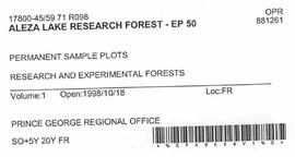
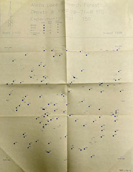
File contains information, including diagrams, measurement charts, and a map, for experimental plot 50.
2007.1.45.09.1
·
Item
·
Aug. 1998
Part of Aleza Lake Research Forest fonds

2007.1.45.14
·
File
·
1998
Part of Aleza Lake Research Forest fonds
File contains information, including diagrams, measurement charts, and a map, for experimental plot 113.
2007.1.45.22.1
·
Item
·
Aug. 1998
Part of Aleza Lake Research Forest fonds
2007.1.45.23.1
·
Item
·
Aug. 1998
Part of Aleza Lake Research Forest fonds
2007.1.45.24.1
·
Item
·
Aug. 1998
Part of Aleza Lake Research Forest fonds

2007.1.80.1.15
·
Item
·
Sept. 1998
Part of Aleza Lake Research Forest fonds
Map commissioned from Ministry of Forests Prince George Region from Madrone Consultants shows Aleza Lake Research Forest Management Compartments and Administrative Boundaries. Map is 1 of 6. Map shows the Aleza Lake Ecological Reserve, Natural Forest Reserve, the Special Management Area, and Riparian Management Research Area.

2007.1.80.1.16
·
Item
·
Sept. 1998
Part of Aleza Lake Research Forest fonds
Map commissioned from Ministry of Forests Prince George Region from Madrone Consultants shows Aleza Lake Research Forest Research Trials and Permanent Plots. Map is 2 of 6. Map shows permanent plot locations, historical timber sales areas, demonstration areas, and research plots.

2007.1.80.1.20
·
Item
·
Sept. 1998
Part of Aleza Lake Research Forest fonds
Map commissioned from Ministry of Forests Prince George Region from Madrone Consultants shows Aleza Lake Research Forest terrain themes. Map is 6 of 6. Map shows the following types of terrain units: typic, slope, percipitous, gullied, hummocky, rocky, alluvial, and organic. Ecosystem classification and mapping by Oikos Ecological Services Ltd.
2006.18.5.65
·
Item
·
Sept. 1998
Part of Aleza Lake Research Forest Society fonds
Map indicates locations of research trials and permanent plots in the Aleza Lake Research Forest. Map produced by Madrone Consultants.

2007.1.80.1.18
·
Item
·
Sept. 1998
Part of Aleza Lake Research Forest fonds
Map commissioned from Ministry of Forests Prince George Region from Madrone Consultants shows an Aleza Lake Research Forest TRIM Base Map. Map is 4 of 6. Map shows the following: roads, old roads, buildings, rail line, transmission line, definite streams, intermittent streams, indefinite streams, marshes, swamps, lakes, wooded area boundaries, intermediate contour lines (20m intervals), and index contour lines (100m intervals).

2007.1.80.1.21
·
Item
·
Sept. 1998
Part of Aleza Lake Research Forest fonds
Map commissioned from Ministry of Forests Prince George Region from Madrone Consultants shows Aleza Lake Research Forest Terrain Resource Inventory Mapping (TRIM). Depicts roads, area boundaries, swamps, streams, marshes, contour lines and index lines.

2007.1.80.1.17
·
Item
·
Sept. 1998
Part of Aleza Lake Research Forest fonds
Map commissioned from Ministry of Forests Prince George Region from Madrone Consultants shows Aleza Lake Research Forest Access and Access Management. Map is 3 of 6. Map shows the following road types: all weather 1-lane gravel road, dry weather road, and proposed road access. Also shows areas for parking/turnaround, toilets, and information signs.

2007.1.80.1.19
·
Item
·
Sept. 1998
Part of Aleza Lake Research Forest fonds
Map commissioned from Ministry of Forests Prince George Region from Madrone Consultants shows Aleza Lake Research Forest ecosystems. Map is 5 of 6. Map shows many sub-types of the following ecosystem types: upland, lowland wet forest, wetlands, and the Bowron floodplain benches. Ecosystem classification and mapping by Oikos Ecological Services Ltd.

2007.1.80.1.22
·
Item
·
Sept. 1998
Part of Aleza Lake Research Forest fonds
Map commissioned from Ministry of Forests Prince George Region from Madrone Consultants shows Aleza Lake Research Forest site series classification. Shows ecosystem types that encompass the SBSwk1 Subzone of the Aleza Lake Research Forest.
2006.18.5.66
·
Item
·
13 June 1997
Part of Aleza Lake Research Forest Society fonds
Item is a British Columbia Forest Cover Map, serial number 093J010. Includes full format forest cover labels.

2007.1.30.8.6
·
Item
·
9 May 1997
Part of Aleza Lake Research Forest fonds
Map accompanies “Aleza Lake Research Forest Management and Working Plan #2 Draft #3”.
2016.5.5.07
·
Item
·
1997
Part of Harry Coates fonds
Item is a map of Aleza Lake Research Forest land management units and boundaries. By Madrone Consultants Ltd. May, 9, 1997.
2016.5.1.74
·
File
·
1997-2002
Part of Harry Coates fonds
File consists of documentation for various field sites. File also includes Harry Coates employment contracts (restricted). File also includes a Forest Cover Map Series 93H.093 1998-JUN-02 010, produced by the inventory branch of the Ministry of Forests, Province of British Columbia; Timber supply area: Prince George.
2006.18.5.61
·
Item
·
Mar. 1996
Part of Aleza Lake Research Forest Society fonds
Map depicts structural stages in the Aleza Lake Research Forest. Shows areas of: pioneer growth, shrub/herb, pole saplings, young forests, mature forests, and old forests. Ecosystem classification and mapping by Oikos Ecological Services Ltd.
2006.18.5.62
·
Item
·
Feb. 1996
Part of Aleza Lake Research Forest Society fonds
Map depicts ecosystems in the Aleza Lake Research Forest. Shows areas of: upland sites without wetland components, upland sites with wetland components, lowland wet forest sites, wetlands, and Bowron floodplain benches. Ecosystem classification and mapping by Oikos Ecological Services Ltd.
2006.18.5.63
·
Item
·
Mar. 1996
Part of Aleza Lake Research Forest Society fonds
Map depicts terrain themes in the Aleza Lake Research Forest. Ecosystem classification and mapping by Oikos Ecological Services Ltd.