The Fred Jeffery Collection consists of three photograph albums comprising a total of 303 b&w photographs all dating from ca.1924-1933. The subject matter of these images consist primarily of the fishing industry, river & landscapes, salmon cannery images (housing, people, workers, machinery, boats) on the Nass River and North Pacific Coast. Notable are the photographs depicting indigenous (Nisga'a) people and places and Chinese and Japanese cannery workers. Identified canneries featured in these photographs include: Mill Bay Cannery, Namu Cannery, Klemtu Cannery, Shushartie Bay Cannery, Balmoral Cannery, North Pacific Cannery, Nass Harbour Cannery, Port Essington Cannery, Kitwanga Cannery, Port Nelson Cannery, Alert Bay Cannery, Dominion Cannery and ABC Co. Cannery. Photographs also include images of the Canadian Pacific Railway in both Vancouver and Sicamous, BC., as well as, images of the Legislative Assembly buildings in Victoria, the 1924 Special Service Squadron ships in Vancouver, early construction of the University of British Columbia in Vancouver, and town overviews of Yokohama, Japan (pre WWII).
Sans titre
Photograph depicts the tops of trees and sky with an unknown man's head at the Prince Rupert Sea Festival.
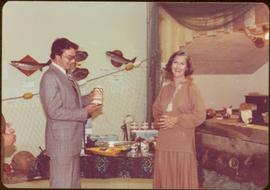
Photograph was taken during a tour of the Skeena riding in the summer of 1978.
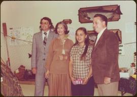
Photograph was taken during a tour of the Skeena riding in the summer of 1978.
Handwritten annotation on verso reads: “Fisheries Museum Prince Rupert”.
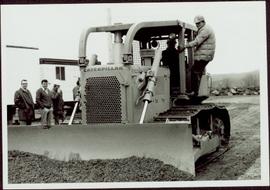
Four unidentified men look on, and portable buildings can be seen in background.
Handwritten annotation on verso reads: “Fairview Opening, Prince Rupert, 1/3/75”.

Photograph depicts a forested mountain, the bottom half of which has been logged and terraced; beneath the mountain is a railroad track and parked vehickes including a schoolbus and two dumptrucks.
Handwritten annotation on verso reads: “Fairview Sodturning, Prince Rupert, 1/3/75”.
File contains slides depicting places in and around Prince Rupert, B.C.
File contains slides depicting places along the Skeena River on the way to Prince Rupert, B.C.

Image depicts the waters of the Hecate Strait.

Image depicts numerous boats docked by the Prince Rupert Fishermen's Co-operative Association from the deck of a ferry, possibly as it's leaving Prince Rupert, most likely for Haida Gwaii.

Image depicts a view of Prince Rupert, B.C.

Image depicts a view of Prince Rupert, B.C.

Image depicts numerous buildings and a small dock somewhere in Prince Rupert, B.C. One of the buildings is labelled "Fishermen's Supply."

Image depicts a large building with numerous vehicles in the foreground.

Image depicts numerous docked boats somewhere in Prince Rupert, B.C.

Image depicts a dock in Prince Rupert, B.C.

Image depicts the Hecate Strait near Prince Rupert, B.C.

Image depicts the Hecate Strait near Prince Rupert, B.C.

Image depicts a grain elevator in Prince Rupert, B.C.

Image depicts numerous boats docked by a buildings identified as the "Prince Rupert Fishermen's Co-operative Association."

Image depicts a boat docked inside what appears to be a type of boathouse, possibly located in Metlakatla near Prince Rupert, B.C.

Image depicts a large vessel docked in Prince Rupert, B.C. The name on its side is "Star Capella." The slide itself is labelled "superport."

Image depicts the ferry to Alaska in the port of Prince Rupert, B.C.

Image depicts a fishing boat on the water somewhere near Prince Rupert, B.C. Only half of its name is visible: "spirit."

Image depicts Metlakatla, located near Prince Rupert, B.C.

Image depicts a view of the downtown core of Prince Rupert, B.C.

Image depicts numerous houses on the cliff-sides in Prince Rupert, B.C.

Image depicts the BC Packers Ltd. cannery in Prince Rupert, B.C.

Image depicts numerous docked boats in Prince Rupert, B.C.

Image depicts a view of what is possibly a shipping yard in Prince Rupert, B.C. The slide is labelled "superport."

Image depicts a view of the port in Prince Rupert, B.C. The slide is labelled "superport."

Image depicts a view of Prince Rupert, B.C.

Image depicts several ships on the water in Prince Rupert, B.C.

Image depicts a road leading to Prince Rupert, B.C.

Image depicts the Skeena River somewhere near Prince Rupert, B.C.

Image depicts the Skeena River alongside Highway 16 en route to Prince Rupert, B.C.
Item is a photograph of a tree stump apparently eaten through by beavers.
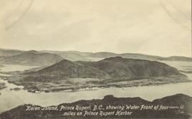
Lofty view of Kaien Island, with other islands in the background. Printed annotation on recto reads: "Kaien Island, Prince Rupert, B.C., showing Water Front of four miles on Prince Rupert Harbor."
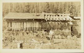
Head on photograph of a trapper standing in front of his cabin in Prince Rupert, BC. The front of the cabin is covered in various pelts. Printed annotation on recto reads: "A Trappers Cabin near Prince Rupert."
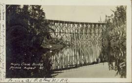
Photograph of a large wooden bridge across Hayes Creek, Prince Rupert, BC. Printed annotation on recto reads: "Hayes Creek Bridge Prince Rupert BC." Handwritten annotation on recto reads: "Dear Mary. Why don't you and my letter hyp[illegible] old [illegible] Louisa A./ P.O. Box 32./ P.R." Handwritten address on verso reads: "Miss Mary Wonoghue Prideaux St., Nanaimo. B.C." Postcard is affixed with a one cent Canadian stamp. Postmarks on verso read: "Prince Rupert B.C. PM Jun 18 11." and "Nanaimo B.C. 18 Jun 21 11."
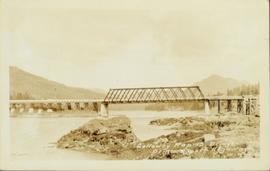
Photograph of a bridge along a rocky shoreline. Printed annotation reads: "Colloway Rapids Bridge Prince Rupert Highway W.W.W." Handwritten annotation on verso is heavily obscured by residual album paper and reads: "PO Box 777 Prince Rupert BC. [Illegible] Lal. This[??] is a piece of our new bridge which [obscured] neats our Island with the mainland. We have had picnics on the other side & [illegible] is open for [illegible] to [illegible]ve ours this side of the [obscured] our stuff to the little [obscured] patronize[??]. Mrs. [illegible] are back again in Rupert [obscured] Kamloops office closed down [obscured] was no chance of transfer. Have not."

Photograph of a large explosion on what appears to be a shoreline. Printed annotation on recto reads: "'Big Blast' Prince Rupert. B.C."

Photograph of a large explosion on a rocky shoreline. A bridge is visible in the foreground and a body of water is partially visible in the background. Printed annotation on recto reads: "McRae Bros Moving Mountains at Prince Rupert BC Apr 24th" Handwritten annotation on verso reads: "Rupert. July 17 1913. Dear [illegible]. Just a card for that album if you've got any room left by now. This is one of the blasts for the clearing of the drydock up here. [Illegible] W.M." Postcard is addressed to: "Miss C.M. Ranip[??] 931 Northlane Av.[sic] Seattle Wash." Two Canadian one cent stamps are affixed on verso. Postmark reads: "Prince Rupert BC. PM Jul 17 13."
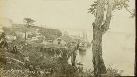
Photograph of the Prince Rupert wharf. A small vessel is docked, and a large tree is in the foreground. Annotation on recto reads: "Prince Rupert Wharf & Harbor. Allen Photo." Handwritten annotation on verso reads: "766[?]"
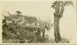
Photograph of the Prince Rupert wharf. A small vessel is docked, and a large tree is in the foreground. Annotation on recto reads: "Prince Rupert Wharf & Harbor. Allen Photo."
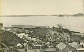
Photo of the Prince Rupert harbour. Many buildings are visible along the shoreline. Annotation on recto reads: "Harbour, Prince Rupert, BC. 1658."

Photo of the Prince Rupert harbour. Many buildings are visible along the shoreline. Annotation on recto reads: "Harbour, Prince Rupert BC. 1658." Handwritten annotation on verso reads: "Early Prince Rupert. Good view of Metlakatla Passage in distance- showery[?] Wolf Island."

Photograph of several buildings down the street in Prince Rupert, including the church. Lumber pallets are littered around the buildings. Annotation on recto reads: "Prince Rupert, BC. 20.10.07."
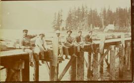
Members of the Collison family casually fishing from a large dock. Handwritten annotation on verso reads: "Collison family fishing from dock (Portland[?] Canal) {Max Elsie Henry Will Arthur Herbert}."
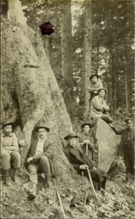
Photograph of Archdeacon WH Collison reclining against a large tree with a group of friends and family. Handwritten annotation on verso reads: "Arch. Collison with sons Max & Arthur & friends in mountains above Portland [?] Canal Me."