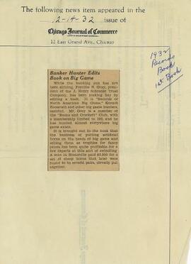
Mostrar 56210 resultados

Archival description
23668 resultados com objetos digitais Mostrar resultados com objetos digitais
Pre-Emptor’s Map, Nechako Sheet
2008.2.013 · Item · 1926
Parte de NBCA Cartographic Collection

Colour-coded map depicting surveyed lands alienated, reserved, in B.C. Land Settlement Board Area, or open for preemption. Depicts land districts, land recording divisions, communities, bodies of water, transport routes, and communication lines.

Preliminary Map, Grenville Channel
2008.2.010 · Item · 1924
Parte de NBCA Cartographic Collection

Colour-coded map depicting lands surveyed as alienated, reserved, and having a timber license, lease, or sale. Depicts land recording divisions, land district boundaries, communities, bodies of water, and transport routes. Includes insets of Stephens Island and Egeria Reach.

Pre-Emptor’s Map, Stuart Lake Sheet
2008.2.009 · Item · 1 December 1923
Parte de NBCA Cartographic Collection

Colour-coded topographic map depicting lands surveyed as alienated, reserved, or statutory timber land. Depicts land district boundaries, land recording divisions, HBC posts, triangulation stations, telephone lines, communities, bodies of water, and transport routes. Defines resource type areas (“Land Form,” “Soil,” “Forest Cover,” “Grazing,” “Geological & Mineralogical,” “Fur-Bearing Animals & Game”). Includes explanatory “Natural Resources Reference.”

Pre-Emptor’s Map, Fort George Sheet
2008.2.008 · Item · 15 February 1923
Parte de NBCA Cartographic Collection

Colour-coded map depicting lands surveyed as alienated, reserved, Statutory Timber Lands, B.C. Land Settlement Board Area, or open for pre-emption. Depicts land districts, land recording divisions, communities, game reserves, bodies of water, transport routes, and communication lines.

Commercial Map of British Columbia
2008.2.007 · Item · 1923
Parte de NBCA Cartographic Collection

Provincial map depicting communities, bodies of water, transport routes, land districts, parks, telegraph/telephone lines, and mining regions, offices, and engineers. Includes Distance Tables (“Coast,” “Roads,” “Railways,” and “World”) and Index of Post Offices.

NBCA Cartographic Collection
2008.2 · Coleção · 1893-2002

Collection consists of an assortment of cartographic materials and architectural plans concerning Northern BC. Included are topographic maps, pre-emptor’s and preliminary maps, physiographic maps, and resource (geological, game, etc.) maps.

2008.2.045 · Item · 1893
Parte de NBCA Cartographic Collection

Consists of 1 topographical map with red colouring entitled "Map of Placer Mines & Quartz Locations in the Vicinity of Williams Creek, Cariboo District B.C." Surveyed and Drawn by Amos Bowman, Mining Engineer, Assisted by James McEvoy, B.A. Sc., printed by the Geological Survey Department, Canada.

Powder King Ski Lodge
2008.2.044 · Item · 1991
Parte de NBCA Cartographic Collection

Item consists of architectural plans created by Stuart C. Ross for the Powder King Ski Lodge, including Floor Plans; Elevations; Building Section; Building Section Details; Reflected Ceiling Plan, Window Schedule, Door Schedule, Room Finish Schedule; Millwork Details; and Roof Plan.

Fort George Heights: $300 an Acre
2008.2.1.039 · Item · 1913
Parte de NBCA Cartographic Collection

Original oversize paper broadside published by British Columbia Estates Ltd. promotes land purchase in Fort George. Includes a price list, a lot plan, and features of lots in the McGregor Addition and the Central Fort George Addition.

Fort George Heights
2008.2.1.038 · Item · [ca. 1913]
Parte de NBCA Cartographic Collection

Original oversize paper broadside published by British Columbia Estates Ltd. promotes land purchase in Fort George. Includes an "Application to Purchase", a price list, and a lot plan. Also includes a promotional article by S.S. Glass entitled "Fort George: A Commercial Centre".

Pre-Emptor’s Map, Fort George Sheet
2008.2.002 · Item · 1916
Parte de NBCA Cartographic Collection

Colour-coded map depicting lands open for pre-emption, lands in “University Reserve,” and lands reserved for public auction. Depicts land recording divisions, communities, bodies of water, transport routes, and game reserves.

Pre-Emptor’s Map, Stuart Lake Sheet
2008.2.001 · Item · 31 July 1914
Parte de NBCA Cartographic Collection

Colour-coded map depicting lands open for preemption, in “University Reserve,” or reserved for public auction. Depicts land recording divisions, communities, bodies of water, and transport routes.

Excerpts from 1922 Wrigley's B.C. Directory
2001.1.097 · Item · 1922
Parte de NBCA Document and Ephemera Collection

Item consists of photocopied pages from the 1922 Wrigley's B.C. Directory. Includes Fort Fraser, Fort George, Fort St. James, Gibson's Landing, Giscome, Giscome Portage, Hutton Mills, Longworth, Loos, Penny, Prince George, Prince Rupert, South Bulkley, South Fort George, and South Francois Lake.

"The Cultural Life of Prince George"
2001.1.096 · Item · 15 Oct. 1962
Parte de NBCA Document and Ephemera Collection

Item is an original typescript prepared by Mrs. Frances Gibbins of Prince George entitled "The Cultural Life of Prince George". The report was prepared as a presentation to Dr. John B. Macdonald, President of the University of British Columbia, on behalf of the Board of School Trustees of School District No. 57 (Prince George). Includes details about music, drama, painting, and arts facilities in Prince George in the 1960s.

Alexander Mackenzie Voyageur Association Collection
2021.08 · Coleção · 1985-2010

Collection consists of material collected by Wallace (Wally) Bergen during his involvement with the Alexander Mackenzie Trail Association. The association was renamed in 1994 to Alexander Mackenzie Voyageur Association. Includes association newsletters, brochures, news releases, a patch, a published map, and a published report.

Sem título
Brochures
2021.08.5 · Dossiê/Processo · 1989-1993
Parte de Alexander Mackenzie Voyageur Association Collection

File includes the following brochures:

  • Alexander Mackenzie Heritage Trail, Nuxalk-Carrier Route. "Roads, Rivers and Trails of the Lower Blackwater River: Including day trips at the Blackwater Bridge"
  • Alexander Mackenzie Heritage Trail, Nuxalk-Carrier Route. "Roads, Rivers and Trails of the Lower Blackwater River: Including day trips at the Euchineko River and Titetown Lake"
  • Alexander Mackenzie Heritage Trail, Nuxalk-Carrier Route. "Roads, Rivers and Trails of the Bella Coola Valley: Including day trips at Burnt Bridge Creek"
  • The Sir Alexander MacKenzie "Canada Sea-to-Sea" Bicentennial Expeditions 1989-1993
  • Follow the Trail to Bella Coola and Retrace the Adventure: Bella Coola, July 22nd, 1993
  • Canada Sea to Sea, The Alexander Mackenzie Voyageur Route: A 1989-1993 Bicentennial Proposal
Silva Forest Foundation fonds
2024.04 · Fundo · 1991-2020

Fonds consists of the records of the Silva Forest Foundation.

Alaska Highway Construction Album
2024.06 · Coleção · 1942

Photograph album contains 134 snapshots showcasing building activity, equipment, logging, and airplanes in British Columbia and the Yukon, taken during the building of the Alaska Highway in 1942. The photographer is unknown. Many of the photographs depict Fort St. John and Fort Nelson.

Some of the photographs are captioned as follows:

  • Looking north at Fort St. John, B.C.
  • P.R.A. Bellanea and Army Norseman sea-planes on Charley Lake near Fort St. John, B.C.
  • Looking toward outlet of Muncho Lake from Float Plane
  • Fort St. John, British Columbia. Canada
  • Colonel Ingalls’ bridge across Liard River
  • Post Office & Government Telegraph Office
  • P.R.A. Camps at Fort St. John, B.C. looking N.E.
  • Post Office & Government Telegraph Office - Fort St. John - 1942
  • Army Ferry on Peace River near Taylor's Flats
  • Looking west on Main Street, Fort St. John, B.C. May - 1942
  • Looking southwest across Summit Lake
  • Public Roads Administration Headquarters Buildings. Fort St. John, B.C. - April - 1942
  • Looking southwest from south bank of Peace River from Old Highway near Taylor Flats, B.C.
  • First Army Headquarters - Fort St. John, B.C. - 1942
  • Beginnings of Fort Alcan - May 1942 - Fort St. John, B.C.
  • Road between 101 and 157
  • Other side Muncho Lake
  • Big Black Bear
  • Liard River, Canada
  • Dog Sled. Muskwa River
  • Temporary Bridge at Muskwa, B.C.
  • Another bridge in British Columbia
  • Above Fort Nelson, B.C. White spot in picture is the “moon”
  • Mountains N-106
  • Coughlin’s equipment at work west of Fort Nelson - Nov. - 1942
  • Near Mile Post 175-N descending to shore of Muncho Lake
  • First Fairbanks sign erected in Fort St. John. Apr. 1942
  • Boat used to cross the Fort Nelson River at Fort Nelson
  • Typical P.R.A. Engineers Camp at Mile 84-N
  • Fort Alcan - near St. John. British Columbia. “1942.”
  • Captain Hinze and Army beachcraft used on Army reconnaissance surveys for Alaska Highway
  • Small single motored aircraft used by P.R.A. on Alaska Highway Reconnaissance flights forced down on Gravel Bar on the Laird [sic] River near Mile 313-N
  • Near Mile 173-N looking at outlet of Muncho Lake
  • Near Mile 145 N. Toad River looking downstream
  • Looking southwest at Muncho Lake at Army operations on shore Pioneer Road. First tote road may be seen above.
  • Hudson Bay Store at Dease Lake, end of truck portage from Telegraph Creek + Wrangell. Beginning of boat freighting to lower port
  • Mile 104 n. Sugarfoot Lake
  • Mile 104 N. Sugarfoot Lake
  • Looking north from Mile 140 N. at Folding Mountains - approx. 8,000 ft high
  • Army forces along Muncho Lake
  • Malamute sled dog at Fort Nelson
  • P.R.A. location. Engineers’ Camp near Mile 165-N
  • Few miles west of Ft. St. John looking downstream at Peace River. Old Fort St. John. Buildings on near shore
  • British Columbia Police Plane in Fort Nelson River at Fort Nelson, B.C.
  • Few miles west of Fort St. John - Looking across Toad River at Little Folded Mountain near Mile 141
  • Looking northwest at P.R.A. an Oakes Camp and Alcan Highway.
  • Clouds after a rainstorm over Teslin Lake, Yukon Territory between Watson Lake and Whitehorse.
  • Toad River and Big Folded Mountain near Mile 142 N
  • Teslin Lake between Watson Lake & Whitehorse Y.K. The lake is 72 miles long
  • Whitehorse, Yukon Territory
  • Dept. of Transport Ferry on Peace River near Taylor Flats.
  • Foothills east of Rocky Mountains between Watson Lake & Whitehorse, Yukon Territory
  • Public Roads Administration (P.R.A.) Camp at Whitehorse, Y.K.
  • Whitehorse end of the White Pass and Yukon Railway from Skagway, Alaska to Whitehorse, Y.K.
  • Husky sled dog. Ft. St. John, B.C.
  • Mile 103 N. Looking east at Army Camp at Mile 102 N. - Summit Lake
  • Opening of new bridge on Sikanni River
  • Peace River Bridge has now replaced this “Ferry” - Fort St. John, B.C
  • Muskwa River new Fort Nelson, B.C.
  • Bridge across the Muskwa River.
  • View of mountains across flat between 101 - and 157
  • Plane at Fort Nelson - Ft. Nelson River
  • Moose Calves
  • Suicide Hill - J 108. Now eliminated from Alaskan Highway
  • Road Construction Equipment Center Boom - Bulldozer and Side Boom
  • Center Boom. Taken at Water Line
  • Early stages of road construction
  • Bulldozing for the Highway
  • Clearing the tinder for the Highway
  • Convoy of trucks on Alaskan Highway
  • Repair Camps off Highway
  • Mud - Mud - Mud - Mud!
"Christ and the rich young ruler"
2009.7.5.065 · Item · [1912?]
Parte de Archdeacon W. H. Collison fonds

Glass slide depicts Heinrich Hoffann's work "Christ and the Rich Young Ruler." Jesus is talking to a young rich man. The young man looks disinterested while Jesus is gesturing to two poor people. Annotation handwritten state, "4H. Christ & the rich Ruler, Hoffman," on stamp, "COPYRIGHT OF FRANZ HANFSTAENGL, PRINTED BY NEWTON & CO (MAKERS) 3 FLEET ST LONDON."

"Specimen of tubercle bacilli in milk"
2009.7.5.064 · Item · [1912?]
Parte de Archdeacon W. H. Collison fonds

Glass slide depicts a 1000 times microscopic view of tuberculosis bacteria in milk made by Dr. Carstairs Douglas. Annotation handwritten state, "V.N. 24." and printed on the slide,"1. Specimen of Tubercle Bacilli in Milk ( x 1000). (Mounted and staind by Dr Carstairs Douglas," and on stamp, "PRINTED BY NEWTON & CO. 3 FLEET ST LONDON."

"Christ & the woman of Samaria at the well"
2009.7.5.063 · Item · [1912?]
Parte de Archdeacon W. H. Collison fonds

Glass slide depicts Jesus sitting at a well talking to a Samarian woman holding a water jug. Annotation handwritten state, "Christ & the woman of samaria at the well" and printed on stamp, "PRINTED BY NEWTON & CO. 3 FLEET ST LONDON."

"The nave Westminster Abbey"
2009.7.5.062 · Item · [1912?]
Parte de Archdeacon W. H. Collison fonds

Glass slide depicts the interior of Westminster Abbey in London. Viewpoint shows the nave at the Western end of the Abbey. Annotations handwritten state, "The nave, Westminster Abbey" and printed on stamp, "PRINTED BY NEWTON & CO. 3 FLEET ST LONDON."

"Westminster Abbey, choir"
2009.7.5.061 · Item · [1912?]
Parte de Archdeacon W. H. Collison fonds

Glass slide depicts the interior of Westminster Abbey in London. Viewpoint shows the main hall from the pews towards the Altar. Annotations handwritten state, "14 Westimster Abbey, choir" and printed on stamp, "PRINTED BY NEWTON & CO. 3 FLEET ST LONDON."

"St. George's Chapel, Windsor"
2009.7.5.060 · Item · [1912?]
Parte de Archdeacon W. H. Collison fonds

Glass slide depicts the interior of St. George's Chapel in Windsor. Viewpoint shows the main hall from the pews towards the Altar. Annotations handwritten state, "St. George's Chapel Windsor" and printed on stamp, "PRINTED BY NEWTON & CO. 3 FLEET ST LONDON."

"Touch me not"
2009.7.5.059 · Item · [1912?]
Parte de Archdeacon W. H. Collison fonds

Glass slide depicts Bernhard Plockhorst's work "Easter Morning." Jesus is standing with his hand raised over a woman on her knees with her hands raised. Annotations handwritten state, "14. Touch me not, (Plockhorst)." and printed on stamp, "COPYRIGHT OF FRANZ HANFSTAENGL NEWTON & CO (MAKERS) 3 FLEET ST LONDON."

"Journey to Emmaus"
2009.7.5.058 · Item · [1912?]
Parte de Archdeacon W. H. Collison fonds

Glass slide depicts Jesus walking to Emmaus with his disciple Cleopas and another disciple. Annotations handwritten state, "395. Journey to Emmaus," and printed on stamp, "NEWTON & CO MAKERS 3 FLEET STREET LONDON."

"Tower Bridge"
2009.7.5.057 · Item · [1912?]
Parte de Archdeacon W. H. Collison fonds

Glass slide depicts Tower Bridge in London. Annotations handwritten state, "Tower Bridge," and printed on stamp, "NEWTON & CO MAKERS 3 FLEET STREET LONDON."

"The Tower of London"
2009.7.5.056 · Item · [1912?]
Parte de Archdeacon W. H. Collison fonds

Glass slide depicts the Tower of London from the South side of the River Thames. There are multiple boats on the river. Annotations handwritten state, "The Tower of London," and printed on stamp, "NEWTON & CO MAKERS 3 FLEET STREET LONDON."

"The choir St. Paul's Cathedral"
2009.7.5.055 · Item · [1912?]
Parte de Archdeacon W. H. Collison fonds

Glass slide depicts the interior of St. Paul's Cathedral. Viewpoint shows the main hall from the pews towards the Altar. Annotations handwritten state, "Choir St. Paul's Cathedral," and printed on stamp, "NEWTON & CO MAKERS 3 FLEET STREET LONDON."

"Durham Cathedral"
2009.7.5.054 · Item · [1912?]
Parte de Archdeacon W. H. Collison fonds

Glass slide depicts a fuling mill on River Wear. Durham Cathedral can be seen in the background behind some trees. Annotations handwritten state, "Durham Cathedral," and printed on stamp, "NEWTON & CO MAKERS 3 FLEET STREET LONDON."