Contains significant materials covering a wide range of topics related to forestry research and forest management practices in Central British Columbia from the 1920s to the 1980s with the bulk of the materials dating from 1924 to 1963. Includes early surveys and descriptions of the Upper Fraser area, early maps and plans of the Research Forest, and historical meteorological registers from the area. Also includes unpublished scientific reports, communications, administrative and technical reports, timber sale records, and general forestry related reports and publications. Photographs include images of the Experimental Station dating from its inception and images of the Young Men's Forestry Training Program situated at Aleza Lake in 1936. Research records include experimental plot files that contain field notebooks dating from 1928 to 1958 which note locations of the experimental plots as well as sample plots from the surrounding areas of Hutton, Penny, and Foreman. The field notebooks also record growth and mortality data of white spruce balsam from 1928 to 1958 and soil types. The fonds also contains some records related to the re-emergence of the Aleza Lake Research Forest (ALRF) in the 1980s and 1990s.
Zonder titel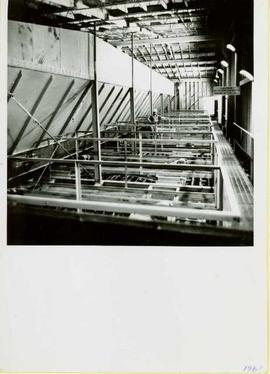
Photograph depicts a man wearing a hard hat standing at what is believed to be the dust collection system in the Cassiar mill. Sign on right reads "CAUTION NO WELDING, BURNING OR SMOKING IN THIS AREA." Handwritten annotation on verso of photograph: "1961".
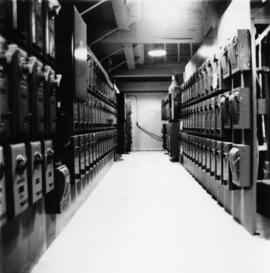
Photograph depicts hallway in power house building. Handwritten annotation on verso of photograph: "1961".
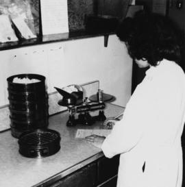
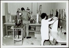
Photograph depicts woman in white lab coat testing quality of asbestos fibre. Special lab instruments sit on counter top. Handwritten annotation on verso of photograph: "1961".
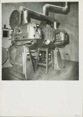
Photograph depicts man seated on stool between two carbon arc Horton movie projectors. These were 16 mm French projectors, and were located at the Cassiar Recreational Center. They were used before the new movie theater was built in the late 1970s. Handwritten annotation on verso of photograph: "1961".
Photograph depicts Ross Duddy with back to photographer, working at table in lab. Unidentified woman stands in right foreground operating unidentified machinery. Miscellaneous equipment and supplies throughout. Handwritten annotation on recto of photograph: "ROSS DUDDY / LAB SUPER".
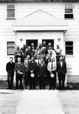
Photograph depicts group of twenty-four men standing on front steps of main office building. Handwritten annotations on recto of similar photograph: "OFFICE STEPS APPROX 1965 / TOP L-R / JULIEN ST. GEORGES / GEORGE TROWSDALE / HANS VELTMEYER / BOB LOVETT / KARL SHULTZ / LOTHAR TISCHLER / - "; "2ND / FRANK CLEMENTS [i.e Kliment?] / BILL PLUMB / HEWETT / - "; "3RD - / - / RENE PASIAUD / DICK [Stevens]"; "4TH / DOC NAVIN / VIC SARAKOSKI / - "; "5TH / CHARLIE GANDER / GORDON EDWARDS / AL FLANIGAN [i.e. Flanagan?] / ANDRE BEGUIN / CHARLIE BRONSON / JACK THORNICROFT". Information in above annotation supplemented with insight from individuals who contributed to Northern BC Archives Facebook Photo ID Project, contact archivist for more information in research file pertaining to item 2000.1.1.3.19.75.

Photograph depicts large square model of the new mill building that was built at the Cassiar plant site in 1970. Model is displayed on green material laid on floor against wall in unidentified room. Machinery modeled inside the structure is colour-coded.
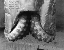
File contains photographs depicting close view of drill bits used in the Cassiar mine. The photos were taken for documentary purposes during an evaluation procedure in which the bits were tested and compared. 32 of the photos are adhered to three reports containing detailed analysis of the condition and function of the drill bits used. Reports were addressed to "E. Komperdo / Assist. Mine Superintendent, Production," and were sent by "Bob Clark / Industrial Engineer" and "E. Isaaks / Engineer Trainee." All of the photos are heavily annotated on verso and recto, often documenting the date, bit number, drilling depth, and notes on general condition.
File contains 6 slide presentations depicting training material for the operation of a P&H excavator published by the Harnischfeger Institute. The presentations depict an introduction to excavator controls and techniques for proper hoist motion, proper swing motion, concerning haulage units, proper propel motion, and proper crowd motion.
Two large black and white prints of infrared dryers annotated on recto "Thompson Pipe and Steel Company Bulk Material Dryers Van Dorn Iron Works Company" and bearing on verso the ink stamp of a photographer from Cleveland, Ohio.
Photographic negatives depict men on tour in unknown locations in Russia. Images depict urban areas, mining areas, construction of buildings, railway, mineral samples, and equipment including dump truck and electric shovel. Also includes images of area speculated to be a mine pit. Men on tour are dressed in formal attire.
Handwritten annotation in pencil on envelope containing negatives: "Russian 'Asbest' Mine Slides" "7 copies of each - 23 negatives - 161 prints".
File contains photographs featuring the tramline at Cassiar which ran from the crushing plant at the mountain mine to the plantsite in the valley (a drop of 427 meters). The first ore was originally transported by truck to the plant until the gravity chute was built in 1953. This chute was replaced with the first aerial tramline model in 1956, which was succeeded by the second model in 1975. This file also includes one photo of the original gravity chute, and one photo depicting a tramline worker.
Additionally there is a collection of eighteen photographs of tramline cars that were being surveyed for damage and condition, and another collection of six photographs of tramline study. The results of this study determined that there was variances in load sizes of the buckets caused by extra material falling off the panfeeder.

Photograph depicts tramline in a strip cleared of trees on McDame Mountain, bucket in foreground. Handwritten annotation on recto of photograph: "#2 SECTION LOOKING NORTH". Photograph was glued to cardboard backing with the annotation: "1962".
This file contains operations at the plantsite:
Below is synopsis of the item level descriptions (see each item for further description)
- locations depicted at Plantsite: mill building, dry rock storage building, tailings pile, gravel pit, power house, and office.
- delivery and installation of a Caterpillar engine, welding repairs underway on a Rustin Diesel Engine in the power house, staff portrait taken by the main office building, and fibre testing
Not done to item level but integrated into subseries file: - Photographic negatives included depict milling and packaging machinery in the mill building.
- 93 slides depicting various activities and equipment at the plantsite including: dry rock storage, screens, collectors, loading trucks, bagging, pallets, tailing pile, lab work by engineers, lab equipment, fibre testing, and fibre samples.
- photographs of conveyor foundations, tailings equipment, Grizzly truck, containers from site mechanical inspection, and portable crushing plant in June 1991.
- photos of fibre samples from lab - on display
- collection of photos of 1970 Mill modification Program of April 1978
- collection of photos from 1961 and 1962 of plantsite lab and asbestos samples. file labeled "Suter - Webb VU Graph Analysis" and "Suter - Webb and Turner Comb Analysis"
- Pressure Packer modification photos done by Chapman Industries in 1986
- Powerhouse equipment from 1979
- additional 43 slides of inside the mill in June 1978. Slides were used at a board meeting.
- negatives of inside of mill
- A photo album of 162 photographs depicting various operations at the plantsite including: drill dust collector, outdoor surroundings, conveyors, and the mine site. (album was originally labelled "Cassiar Plantsite).
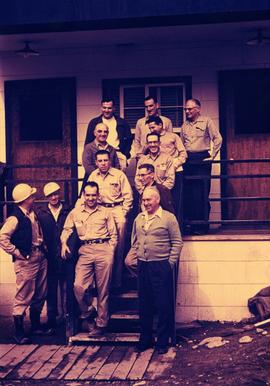
Photograph depicts group of 12 men standing on steps at back of main office. Front row: Jack Berry, Mickey Dopson, Andre Beguin, Fred Murray. 2nd row: Dick Stevens, Rene Pasiaud. Third row: Craigie Hood, Alex Powell. Back row: Dr. Charles Cobb MD, Peter Davies, Chuck Caron (holding paper), Bill Johnston. Berry and Dopson are wearing hard hats. Windows and doors of office building in background. Stamped annotation on recto of photograph: "Munshaw Colour Service Ltd. OCT 24 1958".
Photograph depicts unidentified man in dress shirt and tie standing next to large Caterpillar engine on flatbed. Road in foreground, unidentified building in background. Accompanying note reads: "MTCE 4-01 (b) Cat 3612 Engine".
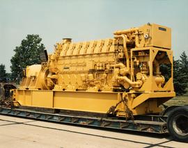
Photograph depicts large Caterpillar engine on flatbed. Road in foreground, trees in background. Accompanying note reads: "MTCE 4-01 (b) Cat 3612 Engine".
Item consists of an exhibit for the British Columbia Utilities Commission's hearings on the Kemano Completion Project entitled "Notes from the Department of Fisheries and Oceans Documents, pages 005359 to 005364, dated May 22, 1987".
Item consists of an exhibit for the British Columbia Utilities Commission's hearings on the Kemano Completion Project entitled "Submission by M.G. Fowle, dated November 9, 1993".
Item consists of an exhibit for the British Columbia Utilities Commission's hearings on the Kemano Completion Project entitled "Submission by A. Belsham the Fort Fraser Women's Institute, dated November 18, 1993".
Item consists of an exhibit for the British Columbia Utilities Commission's hearings on the Kemano Completion Project entitled "Submission by G. Kopy of the East Francois Lake Community Association, dated November 18, 1993".
Item consists of an exhibit for the British Columbia Utilities Commission's hearings on the Kemano Completion Project entitled "Submission by D. Raymond of the Becker Road District Rural Development Society (November 18, 1993)".
Item consists of an exhibit for the British Columbia Utilities Commission's hearings on the Kemano Completion Project entitled "Submission by Gwen Yeulet of the Fort Fraser Chamber of Commerce, dated November 18, 1993".
Item consists of an exhibit for the British Columbia Utilities Commission's hearings on the Kemano Completion Project entitled "Song entitled "A River Forever" by D. Gow and J. Neilson".
Item consists of an exhibit for the British Columbia Utilities Commission's hearings on the Kemano Completion Project entitled "Submission by K.R. Ponsford, dated November 18, 1993".
Item consists of an exhibit for the British Columbia Utilities Commission's hearings on the Kemano Completion Project entitled "Submission by C. McNolty, dated November 15, 1993".
Item consists of an exhibit for the British Columbia Utilities Commission's hearings on the Kemano Completion Project entitled "Submission by Jenny Mickelow (November 19, 1993)".
Item consists of an exhibit for the British Columbia Utilities Commission's hearings on the Kemano Completion Project entitled "Submission by Henry Van Andel (November 19, 1993)".
Item consists of an exhibit for the British Columbia Utilities Commission's hearings on the Kemano Completion Project entitled "Submission by June Wood (November 19, 1993)".
Item consists of an exhibit for the British Columbia Utilities Commission's hearings on the Kemano Completion Project entitled "Submission by Doug Goodwin on behalf of the New Caledonia Canoe Club (November 19, 1993)".
Item consists of an exhibit for the British Columbia Utilities Commission's hearings on the Kemano Completion Project entitled "Submission by Monte Olson (November 19, 1993)".
Item consists of an exhibit for the British Columbia Utilities Commission's hearings on the Kemano Completion Project entitled "Document entitled "Alcan's Kemano Completion Project and its Impact on Float Plane Activities on the Nechako River" by McNeal and Associates for the Vanderhoof Flying Club dated November 5, 1993.".
Item consists of an exhibit for the British Columbia Utilities Commission's hearings on the Kemano Completion Project entitled "Document by Alcan Smelters and Chemicals Ltd. entitled "Kemano: Energy for the Future"".
Item consists of an exhibit for the British Columbia Utilities Commission's hearings on the Kemano Completion Project entitled "Article from Canadian Dimension magazine entitled ''Foiled Again: Alcan Smelters and Chemical Ltd. and Manitoba"".
Item consists of an exhibit for the British Columbia Utilities Commission's hearings on the Kemano Completion Project entitled "Play presented by the Nechako Environmental Youth Alliance entitled "Crossroads"".
Item consists of an exhibit for the British Columbia Utilities Commission's hearings on the Kemano Completion Project entitled "Submission by E. Cresswell, Councillor of Vanderhoof, dated November 23, 1993".
Item consists of an exhibit for the British Columbia Utilities Commission's hearings on the Kemano Completion Project entitled "Submission by G.A. LaBrash, dated November 24, 1993".
Item consists of an exhibit for the British Columbia Utilities Commission's hearings on the Kemano Completion Project entitled ""Economic Impact Study of Proposed BCTMP Mill in Vanderhoof, B.C."".
Item consists of an exhibit for the British Columbia Utilities Commission's hearings on the Kemano Completion Project entitled "Submission by M. Sullivan (November 24, 1993)".
Item consists of an exhibit for the British Columbia Utilities Commission's hearings on the Kemano Completion Project entitled "Submission by P. Sholty (November 24, 1993)".
Item consists of an exhibit for the British Columbia Utilities Commission's hearings on the Kemano Completion Project entitled "Submission by D. Fawcett, dated November 24, 1993".
Item consists of an exhibit for the British Columbia Utilities Commission's hearings on the Kemano Completion Project entitled "Submission by C. Serhan, dated November 24, 1993".
Item consists of an exhibit for the British Columbia Utilities Commission's hearings on the Kemano Completion Project entitled "Submission by C. Ford of the Environment Conservation Organization, dated November 25, 1993".
Item consists of an exhibit for the British Columbia Utilities Commission's hearings on the Kemano Completion Project entitled "Submission by B.B. Meisner (November 25, 1993)".
Item consists of an exhibit for the British Columbia Utilities Commission's hearings on the Kemano Completion Project entitled "Submission by L. Poile, dated November 24, 1993".
Item consists of an exhibit for the British Columbia Utilities Commission's hearings on the Kemano Completion Project entitled "Submission of Mennonite Central Committee, B.C., dated November 26, 1993".
Item consists of an exhibit for the British Columbia Utilities Commission's hearings on the Kemano Completion Project entitled "Submission by B. Gardiner, M.P. for Prince George- Bulkley Valley, dated December 1993".
Item consists of an exhibit for the British Columbia Utilities Commission's hearings on the Kemano Completion Project entitled "Submission by L. Broddy, Dated November 25, 1993".
Item consists of an exhibit for the British Columbia Utilities Commission's hearings on the Kemano Completion Project entitled "Submission by P.T. Sanborn (December 6, 1993)".