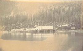
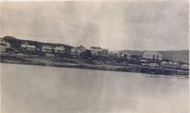
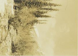
Photograph depicts the Cassiar townsite behind shadow in foreground. Plantsite can be seen including the mill, dry rock storage building, tailings pile, and many other buildings. Mountains in background. Handwritten annotation on recto: "<- 13 1/2" ->". (This photograph was made into a promotional poster.)
Photograph depicts the North peak of McDame mountain after extensive strip mining, South peak unmined in background. Old mine garage visible on right of West peak in foreground. Crusher plant partially visible on far right. Photograph believed to have been taken just prior to the development of the pit mine between the North and West peak.
Photograph depicts a portion of the pit in foreground at the Cassiar mine. Crushing plant visible in centre below base of West peak. Footwall road in midground, mine valley in background. Building near trucks at top of pit was called the "shifter shack," where crews were relieved or dropped off for work.
Photograph depicts a portion of the Cassiar pit in right foreground. Crushing plant visible to left of pit, West peak visible in right background. Mountain range can be seen in distance.
Photograph depicts exposed asbestos fibre in talus.
Image of man seated with shovel in mountainous area, loose asbestos fibre in background. This photograph is believed to be either a double exposure of two images, or a print made from two negatives at once. Photo depicts an unidentified man sitting on the south ridge of the Cassiar ore body, where the crusher and rock reject plant would eventually sit. Valley in background appears to depict the "Footwall Road," which was cut into the mountain from the pit to the crusher plant and became the mine's main haul road.
Photograph depicts buildings near West Peak of Cassiar mine. Haul trucks parked near old mine garage in background, new mine garage and unknown buildings in foreground. Mine valley crosses midground, expansive western mountain range in background.
Photograph depicts chute from distance. Annotation on verso of photograph: "CASSIAR ASBESTOS CORP. LTD. MINE AND ORE CHUTE ON McDAMES MOUNTAIN".
Photograph depicts large dry rock storage building on left, mill in background, dryer building on far right. Road and power poles cross foreground, mountains stand in background. Photo caption next to printed copy of image in 1953 Annual Report: "Completed dry rock storage and dryer buildings."
Photograph depicts an unidentified man standing to left of large puddle in gravel pit, mountain peaks in background. Photo speculated to have been taken on the plant, or near the Cassiar airstrip, facing south west. Stamped annotation on recto of photograph: "JUN. 1987".
Photograph depicts yellow conveyor belt in foreground over gravel pit, dump truck behind in midground. Mountains visible in background. Photo speculated to have been taken at the plant or near the Cassiar airstrip. Stamped annotation on recto of photograph: "JUN. 1987".
Photograph depicts mine area at Cassiar, crushing plant visible on left. Various mine buildings visible midground. Blasthole drills, shovels, dozers, and dump trucks can be seen on bench in foreground at 6430 elevation. Handwritten annotations on recto of photograph: "6"; "View looking NW from top of S. peak 6790 elev. on 6430 stripping bench on it and 6050 ore bench further down on left."; "July 1961".
Photograph depicts men standing near two Atlas Copco Drillmasters (blasthole drills). These are precision hammer drills which had their own power source. Large bags of ammonium nitrate in foreground, mountainside in background. The men depicted here were likely members of the explosive crew. It is believed that this photo was taken on the North ridge, near the cirque dump. Handwritten annotation on verso of photograph: "1961".
Photograph depicts a man wearing a hard hat preparing long narrow bags of explosive material. Large bags of ammonium nitrate in right foreground, mountains in background. Handwritten annotation on verso of photograph: "1961".
Photograph depicts crawler cable shovel and dump truck in excavation area of mine. Handwritten annotation on verso of photograph: "1961".
Photograph depicts a Chevrolet pickup truck on highway to right of Mud Lake, at Km 632 on the Stewart-Cassiar Highway. Forest on hillside in background.
Photograph depicts palletizer machinery, where bags of asbestos fibre were shrink-wrapped and made ready for shipping pallets. Palletizer was located near shipping (believed to be in mill building). Unidentified man visible in machinery on far left.
Photograph depicts Joseph wearing safety gear while standing at testing equipment on raised sampling station. Sign below Joseph reads "DO NOT DISTURB / SAMPLING IN PROGRESS / PROPERTY OF ENVIRONMENTAL CONTROL DEPT. / CASSIAR ASBESTOS LTD." Helen Joseph took air quality tests in the working areas and town (see item 2000.1.1.3.19.135). Power lines, unidentified building, and mountain base visible in background. Photo was taken during winter.
Photograph depicts three men with fishing gear. Trees and mountains in background. Left to right: Plato Malezemoff (holding fish), Jack Christian, Tam Zimmermann.
Photograph depicts two men at a sawmill. A beehive burner is in the background.
Item is a photograph of a forested area with a partially frozen river, exact location unknown.
Item is a photograph of a small mill operation.
Item is a photograph of piles of bark in a field.
Photograph depicts two men sitting on a staircase of a wooden walkway leading through a forest.
Photograph depicts two unidentified men on a wooden bridge that leads through a heavily wooded area.
Photograph depicts a landscape shot of rushing water with a forested area in the background.
Photograph depicts a landscape shot of a grassy area with fruit-bearing trees in the background.
Photograph depicts a cannery on pilings with a body of water in the foreground with a forested area in the background.
Photograph depicts cannery buildings on wooden pilings with a body of water in the foreground and a forested area in the background.
Photograph depicts wood planks piled on a dock with wood buildings built along the shoreline of the background.
Photograph depicts a man diving off a wooden dock while a man and woman and two young children watch from the dock.
Photograph depicts a cannery on wood pilings with several other buildings along a forested shoreline with a body of water and boat in the foreground.
Photograph depicts a two men standing on piles of whale bones at a whaling station. Annotation on verso of photograph states: "Pile of whale bones, Whaling station, Vancouver Is."
Photograph depicts numerous buildings along a shoreline with water in the foreground.
Photograph depicts a wooden building on a rocky shoreline with a forested area in the background.
Photograph depicts a building on a rocky shore with water in the foreground.
Photograph depicts a snow-covered mountain range with a forested area in the foreground.
Photograph depicts an unidentified man is lying on the ground next to a roaring campfire. Some clothes are visible on the ground next to him while some woolen socks are slung across a branch above him.
Photograph depicts a deer standing amongst the brush within a snow-covered landscape with a forest visible in the background.
Photograph depicts depicts a brush covered valley with tree-covered mountains on either side.
Photograph depicts a mountain pass covered in snow with trees on either side of the pass.
Photograph depicts a small creek running through a wooded landscape with part of the Rocky Mountains visible in the background.
Photograph depicts Roche Myette along Davona Creek near a campsite.
Photograph depicts an unidentified man sitting on a log skinning a goat that is laying on a blanket in front of him.