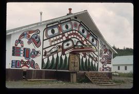
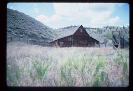
The item is a photograph depicting a front view of an old white barn with a rainbow painted on the front.
The item is a photograph depicting a front and side view of an old white barn with a rainbow painted on the front. The photograph is taken from a field.
The item is a closeup black and white photograph depicting the front of an old white barn with a rainbow painted on the front.
The item is a closeup black and white photograph depicting the front and side of an old white barn.
The item is a black and white photograph depicting a garage and covered storage area on a farm.
The item is a black and white photograph depicting a boarded up workshop on a farm.
The item is a black and white photograph depicting the front of a white house in a rural location.
The item is a black and white photograph depicting the front and side of a white house on a farm.
The item is a photograph negative depicting the front of the Kinney house at 2249 Queensway Street, South Fort George. The negative is from before 1985, as that is the year the house burnt down.
The item is a photograph slide reproduction depicting houses in the flooded Cottonwood area, Prince George in 1972. Annotation on the slide states, "Cottonwood Isl 1972."
The item is a photograph slide reproduction depicting a flooded river and covered area in Fort George Park, currently Lheidli T'enneh Memorial Park.
The item is a photograph slide reproduction depicting the raised floodwaters on the Fraser River and the Cottonwood Trail.
File consists of notes, letters, and reproductions relating to the "Arrival of Steel" CN Railway plaque in Prince George. Includes: "Invitation" from the City of Prince George for the unveiling of the CN plaque (27 Jan. 1989) and correspondence letters between CN and the City of Prince George (1987-1989). Also includes photographs depicting the CN plaque and the unveiling ceremony (Jan. 1989).
The item is a photograph depicting a 1/48 scale model of the Cameron Street bridge. The angle is a side view of the bridge with a blue and a yellow model car on the bridge. Annotation on the reverse side of the photograph states, "Oct. 2008 1/48 scale model of the Cameron St. bridge 1931-2005 by Roy Groeneveld."
Image depicts the house of the owner of Gang Ranch.
Image depicts the Alkali Lake Ranch in Alkali Lake, B.C.
Image depicts a view of the Fraser River in Lillooet, B.C.
Image depicts some farmland in Lillooet, B.C.
Image depicts an old church located somewhere in Lillooet, B.C.
Image depicts a view of Lillooet, B.C.
Image depicts two bridges over the Fraser River, located somewhere in Lillooet, B.C.
Image depicts the start of Joffre Creek Road, most likely somewhere in the Joffre Lakes Provincial Park.
Image depicts the Britannia Mine, which closed in 1974 and is now a museum. "Anaconda" was the last operating owner.
Image depicts numerous power lines and a road somewhere north of Squamish.
Image depicts rail road tracks and several buildings in Pemberton, B.C.
Image depicts some power lines and mountains near Pemberton, B.C.
Image depicts what appears to be an apartment building among several others in an uncertain location.
Image depicts a lake with a "Swim at Own Risk" sign at an uncertain location.
Image depicts a building painted with First Nations art in New Aiyansh.
Image depicts several children and numerous adults inside a church in Deadman Creek, near Kamloops, B.C.
Image depicts the Ranch house on the historic Hat Creek Ranch site north of Ashcroft, B.C.
Image depicts an old barn on the historic Hat Creek Ranch site north of Ashcroft, B.C.
Image depicts the front of the ranch house on the historic Hat Creek Ranch site north of Ashcroft, B.C.
Image depicts the Lajoie Dam on the Bridge River from the upstream side.
Image depicts Bralorne, B.C.
Image depicts what is possibly an old, rundown mill in Bralorne, B.C.
Image depicts several houses in Bralorne, B.C.
Image depicts a few boarded-up buildings in Bralorne, B.C.
Image depicts an area of Barlone, B.C. surrounded by trees.
File contains slides depicting images of areas around Dease Lake, B.C.
Image depicts a number of identical buildings and vehicles at "Driftwood Creek" in the Driftwood Canyon Provincial Park.
Image depicts a cabin on the "west arm" of Takla Lake.
Image depicts a few piles of culverts in Leo Creek, B.C.
Image depicts a building, possibly an office building, next to a set of rail road tracks in Leo Creek, B.C. An unknown individual is present, and a number of barrels and culverts are visible in the foreground.
File contains slides depicting places in and around the Junction Sheep Range Provincial Park south-west of Williams Lake.
Image depicts a sign titled "Chilcotin Wildlife Management Area" somewhere near Riske Creek, B.C. It reads: "This trail has been provided by the Fish and Wildlife Branch in co-operation with Riske Creek Ranching Ltd., as access to the Chilcotin Wildlife Management Area. Please do not leave the the trail as the surrounding land is private property."
Image depicts a ranch house in Meldrum Creek, B.C.
Image depicts two women at a table; the one on the right is possibly Sue Sedgwick. The image may have been taken in Meldrum Creek, B.C.