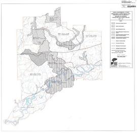
Logging plan of Sinclair Spruce Lumber Company's T.S.X. 73378 at Hubble Creek shows areas to be cut.
Logging plan of Sinclair Spruce Lumber Company's T.S.X. 73378 at Hubble Creek shows areas to be cut. Annotations show areas logged.
Item is a photocopied map of the Aleza Lake area annotated to show transects.
Item is a reproduced map of Aleza Lake annotated to show a 1994 RFP study area.
Item is a photocopied Aleza Lake Forest map with forest cover labels annotated to show 1994 RFP study area.
Item is a photocopied and annotated Aleza Lake Forest map with forest cover labels.
Item is a photocopied Aleza Lake Forest map with forest cover labels, annotated to show 1995 sample transects.
Map reflects reserve boundary, roads, trails, 20 feet contour intervals, air photo centre, declination, swamps, and mile post at the Aleza Lake Forest Reserve.
Map reflects reserve boundary, roads, trails, 20 feet contour intervals, air photo centre, declination, swamps, and mile post at the Aleza Lake Forest Reserve.
Map reflects lot and STL lines, timber sale boundaries, Highway 16, roads, beetle infested areas, and plots X91971 to X91980, and X89946.
Map reflects boundaries for the Aleza Lake Experiment Station, permanent sample plots, timber sales locations, and the Ecological Reserve.
Map reflects soil and landforms of Giscome area.
Map reflects highways, main, branch and property roads, trails, public sustained yield unit boundaries, cutting permit boundary, contours, height of land, edge of lake, merchantable and immature timber, non-commercial cover, and swamps.
Map reflects forest type boundary line, bogs and swampy non-forested areas, creeks, lakes, rivers, tree species labels of spruce, balsam, and birch, stand descriptions, historical timber sale boundaries, stand history symbol, gravelled secondary roads, unimproved old roads, management compartment boundary, research forest boundary, ecological reserve boundary, and old growth emphasis areas.
Map reflects forest type boundary line, bogs and swampy non-forested areas, creeks, lakes, rivers, tree species labels of spruce, balsam, and birch, stand descriptions, historical timber sale boundaries, stand history symbol, gravelled secondary roads, unimproved old roads, management compartment boundary, research forest boundary, ecological reserve boundary, and old growth emphasis areas.
Map reflects forest type boundary line, bogs and swampy non-forested areas, creeks, lakes, rivers, tree species labels of spruce, balsam, and birch, stand descriptions, historical timber sale boundaries, stand history symbol, gravelled secondary roads, unimproved old roads, management compartment boundary, research forest boundary, ecological reserve boundary, and old growth emphasis areas.
Large scale map shows Aleza Lake Research Forest permanent sample plot 103. Includes information about live and dead trees and their species (spruce, balsam, birch, douglas fir). Also includes remeasurement history. Plot 103 was established in 1926 and is an unlogged, old growth, uneven aged, spruce-balsam stand.
Large scale map shows Aleza Lake Research Forest permanent sample plot 112. Includes information about live and dead trees and their species (spruce, balsam, birch, douglas fir). Also includes remeasurement history. Plot 112 was established in 1926 and is an unlogged, old growth, uneven aged, spruce-balsam stand.
Map commissioned from Ministry of Forests Prince George Region from Madrone Consultants shows Aleza Lake Research Forest Management Compartments and Administrative Boundaries. Map is 1 of 6. Map shows the Aleza Lake Ecological Reserve, Natural Forest Reserve, the Special Management Area, and Riparian Management Research Area.
Map commissioned from Ministry of Forests Prince George Region from Madrone Consultants shows Aleza Lake Research Forest Research Trials and Permanent Plots. Map is 2 of 6. Map shows permanent plot locations, historical timber sales areas, demonstration areas, and research plots.
Map commissioned from Ministry of Forests Prince George Region from Madrone Consultants shows Aleza Lake Research Forest Access and Access Management. Map is 3 of 6. Map shows the following road types: all weather 1-lane gravel road, dry weather road, and proposed road access. Also shows areas for parking/turnaround, toilets, and information signs.
Map commissioned from Ministry of Forests Prince George Region from Madrone Consultants shows an Aleza Lake Research Forest TRIM Base Map. Map is 4 of 6. Map shows the following: roads, old roads, buildings, rail line, transmission line, definite streams, intermittent streams, indefinite streams, marshes, swamps, lakes, wooded area boundaries, intermediate contour lines (20m intervals), and index contour lines (100m intervals).
Map commissioned from Ministry of Forests Prince George Region from Madrone Consultants shows Aleza Lake Research Forest ecosystems. Map is 5 of 6. Map shows many sub-types of the following ecosystem types: upland, lowland wet forest, wetlands, and the Bowron floodplain benches. Ecosystem classification and mapping by Oikos Ecological Services Ltd.
Map commissioned from Ministry of Forests Prince George Region from Madrone Consultants shows Aleza Lake Research Forest terrain themes. Map is 6 of 6. Map shows the following types of terrain units: typic, slope, percipitous, gullied, hummocky, rocky, alluvial, and organic. Ecosystem classification and mapping by Oikos Ecological Services Ltd.
Map commissioned from Ministry of Forests Prince George Region from Madrone Consultants shows Aleza Lake Research Forest Terrain Resource Inventory Mapping (TRIM). Depicts roads, area boundaries, swamps, streams, marshes, contour lines and index lines.
Map commissioned from Ministry of Forests Prince George Region from Madrone Consultants shows Aleza Lake Research Forest site series classification. Shows ecosystem types that encompass the SBSwk1 Subzone of the Aleza Lake Research Forest.
Map reflects reserve boundary, roads, trails, 20 feet contour intervals, air photo centre, declination, swamps, and mile post at the Aleza Lake Experiment Forest.
Map reflects reserve boundary, roads, trails, 20 feet contour intervals, air photo centre, declination, swamps, and mile post at the Aleza Lake Experiment Forest.
Map reflects reserve boundary, roads, trails, 20 feet contour intervals, air photo centre, declination, swamps, and mile post at the Aleza Lake Experiment Forest.
Accompanied by a 1942 job estimate cost summary sheet for the "Survey railway location west of Fairbanks" work to be done for the Alaska Western Railway project approved by a Colonel of the U.S. Army Corps of Engineers.
Original linen map depicts mining claims in the Cassiar District of British Columbia that were located in 1900-1901: L. 115 Princess Louise, L. 310 North Star, L. 311 Bonanza, L. 309 Emerald, and L. 312 Emma.
Colour-coded topographic map depicts forest stands of different heights.
Shows routes and ports of call from Smith Sound to Portland Canal including locations of many canneries and mines now no longer extent.
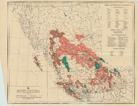
Item consists of a map of British Columbia showing Status of Sustained-Yield Forestry Programme as at December 31, 1969 with colour coded areas indicating Public Sustained Yield Units, Special Scale Areas, Tree Farm Licences, and Major Parks.
Map depicts the City of Prince George in 1976, including the Fraser River, Nechacko River, Cariboo Highway, Carney St., and Patricia Blvd. where the electoral district boundary was proposed along for the two districts of Fort Nelson-Peace River and Prince George-Bulkley Valley.
Map depicts the city of Victoria and the electoral districts of Esquimat-Saanich, Victoria and Cowichan-Malahat-The Islands.
Map depicts the city of Vancouver, including the electoral districts of Comox-Powell River, Capilano, North Vancouver-Burnaby, Mission-Port Moody, Burnaby, Fraser Valley West, New Westminster-Coquitlam, Surrey-White Rock-North Delta, Richmond-South Delta, Vancouver South, Vancouver Kingsway, Vancouver Quadra, Vancouver Centre, and Vancouver East.
Map depicts Bee Peak, Golden Mountain, Mount Fetterly, Mount Brook, Ear Mountain, Sunday Peak, Graham Inlet, and Taku Arm of Tagish Lake.
Map depicts the Gulf of Alaska, Pacific Ocean, Chicagof Island, Baranof Island, Alaskan Boarder, Yukon Territory Boarder, Telegraph Creek, Dease Lake and "Mount Brook" along the Graham Inlet.
Map depicts British Columbia in its entirety as-well as smaller subsequent maps of Vancouver, Victoria and Vicinity, Prince George, Kamloops, Nelson, and Vancouver Island.
Map depicts the whole of Canada and notes: gas pipelines, gas gathering lines, proposed gas pipelines, oil pipelines, oil gathering lines, proposed oil pipelines, gas fields, oil fields, refining centres, extraction plants, and oil sands. There is a smaller subsequent map of Alberta highlighting these features in greater detail.
Map depicts proven on & offshore oil & gas areas, and probable oil & gas areas in less then 1000' water. The map conveys the North Pole in the centre and spans out to include Canada, Europe and the "Union of Soviet Socialist Republics."
Map depicts sea floor of the Beaufort Sea, fault lines, and diapirs.


