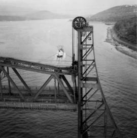
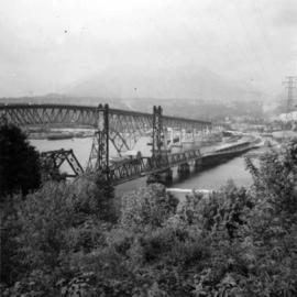
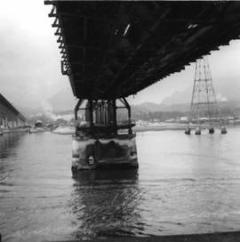
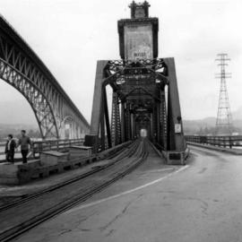
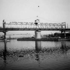
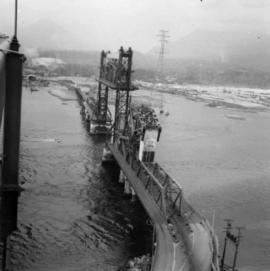
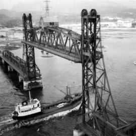
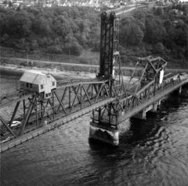
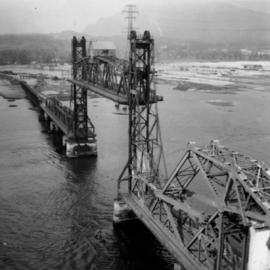
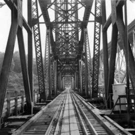
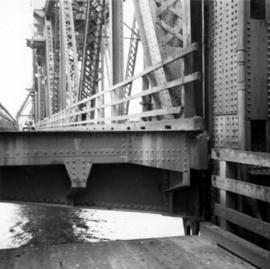
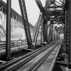
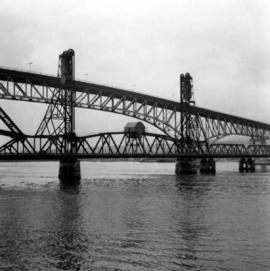
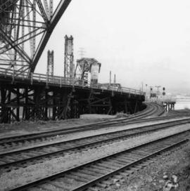
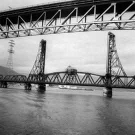
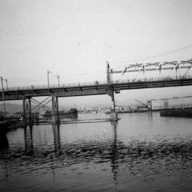
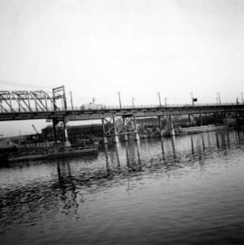
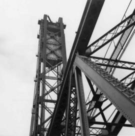
Photograph depicts the north side lifting tower of the Second Narrows railway bridge in Vancouver, BC
Photograph depicts the Second Narrows railway bridge in Vancouver, BCfrom the south end of the road bridge with the lifting span up.
Photograph depicts the Second Narrows Railway Bridge in Vancouver, BC, as a coastal tanker going upstream to a refinery passes beneath it.
Photograph depicts the Second Narrows Railway Bridge in Vancouver, BCas the lifting span is being lowered. The span lifts about every 1 to 2 hours.
Photograph depicts the Second Narrows Railway Bridge in Vancouver, BCwith the lifting span up.
Photograph depicts the Second Narrows Railway Bridge in Vancouver, BC, as the lifting span is starting to drop. The view is looking east towards Capitol Hill and Berry Point.
Photograph depicts the road and rail bridges at Second Narrows, Vancouver B.C. The photograph was taken from Boundary Rd. looking north.
Photograph depicts the underside of the lifting span of the Second Narrows Railway Bridge in Vancouver, BCView is from the south, fixed side.
Photograph depicts the Second Narrows Bridge from the south end, showing the railway in the center and the south and north bound road traffic ways on either side. The latter is disused.
Photograph depicts the Second Narrows Railway Bridge in Vancouver, BC; view from the lifting span looking south.
Photograph depicts the lifting span of the Second Narrows Bridge with a motor car on the west roadway, as the span is about to close to its normal, flush position.
Photograph depicts the Second Narrows Railway Bridge in Vancouver, BC, from a view on the lifting span looking north.
Photograph depicts the Second Narrows Railway Bridge in Vancouver, BCfrom the south east shore.
Photograph depicts the rail approach to the Second Narrows Railway Bridge in Vancouver, BCThe shot taken on CPR trackage and from underneath the road bridge on the south bank.
Photograph depicts the Second Narrows Railway Bridge, looking east.
Photograph depicts a trestle bridge for road traffic leading to the Second Narrows Bridge in Vancouver, BCThe shot is taken from the south bank.
Photograph depicts the Fraser St. road bridge over the north section of the north arm of the Fraser River (ie. between Vancouver and Mitchell Island). Shot is looking northeast.
Photograph depicts the road bridge crossing the south section of the north arm of the Fraser River at Fraser St. The view is from the north bank of Lulu Island.
Photograph depicts the Fraser St. road bridge over the north section of the north arm of the Fraser River, looking north from Mitchell Island to Vancouver, BC
Photograph depicts a wooden arch supporting the sagging Georgia Viaduct in Vancouver, BCThe road in the foreground is Taylor Way.
Photograph depicts the Cambie St. Bridge in Vancouver, BC, looking east and showing the north fixed span of the bridge.
Photograph depicts the Cambie St. Bridge in Vancouver, BC, looking southeast and showing the southern fixed span on the bridge.
Photograph depicts the Cambie St. Bridge in Vancouver, BC, looking east and showing the central swing span.
Photograph depicts the Cambie St. Bridge in Vancouver, BC, showing the west side and view facing south.
Photograph depicts a bandstand at English Bay in Vancouver, B.C.
Photograph depicts what is believed to be the only remaining "summer cottage" on Beach Ave. in English Bay.
Photograph depicts a former Sailor's Home at the southeast corner of the intersection at Alexander St. and Jackson St. in Vancouver, B.C.
Photograph depicts the former "Terminus Hotel" on 32 Water St., 50 yards from the center of old Vancouver.
Photograph depicts an old building at 119 Water St. in Vancouver, B.C.
Photograph depicts the headquarters and general offices of the National Harbours Board in Vancouver, B.C., located at the foot of Dunlery St.
Photograph depicts the building for the Vancouver Supply Company located at 25 Alexander St. in Vancouver, B.C. It is at the center of the old downtown and may have been a former fire hall.
Photograph depicts the Mussenden Building used by the Hudson's Bay Company. It is located on Water St. in Vancouver, B.C. View is from the north side looking east.
Photograph depicts the former C.P.R. route connecting existing False Creek rail yards and the Burrard shoreline main line. The view is looking southwest from the intersection of Powell St. (in foreground) and Columbia St. (not seen) in Vancouver.
Photograph depicts a home located at 1459 Robson St., at the northeastern intersection of Robson and Nicola, in Vancouver B.C.
Photograph depicts an old church or school being demolished at 1701-1721 West 3rd Ave. (and Pine), in Vancouver, B.C.
Photograph depicts a home at 1310 Comox St. in Vancouver, B.C. View is of the east side of the house, facing Jervis St.
Photograph depicts a stone house on 17th St. and Esquimalt St. in West Vancouver, B.C.
Photograph depicts the Buckingham Apartments at 925 Cardero St.and Barclay St. in Vancouver, B.C.
Photograph depicts the Grand Central Hotel at the intersection of Marpole Ave and Hudson St. in south Vancouver. The hotel was built in 1912 by J.J. Graver and run from 1913-1915. It re-opened in 1920 as a home for incurables (veterans). In 1937 it became the provincial infirmary and closed in May 1965.
Photograph depicts the corner building on West Georgia and Chilco St., facing Stanley Park in Vancouver B.C. View looking south across Georgia St.
Photograph depicts a west end fire hall in Vancouver on Nelson and Nicola St.
Photograph depicts a corner building on Chilco and West Georgia St. facing Stanley Park in Vancouver, B.C. The view is looking east across Chilco St.
Photograph depicts a church on a reservation at Mosquito Creek in North Vancouver, B.C.
Photograph depicts the site of a former C.P.R. connection between the mainline into Vancouver and False Creek yards at West Pender St. In Vancouver. The rails are not used but still appear in the street and on the parking lot on the far side. Another parallel set of tracks 30 yards to the east are in daily use.
Photograph depicts Hamilton St. in Vancouver, looking northeast.
Photograph depicts a former C.P.R. connection between the False Creek yards and the south side of Vancouver harbour on West Pender St. in Vancouver, B.C. This spur used daily to get cars into the B.C. Electric Rail yard at the Georgia Viaduct from the C.P.R. False Creek yards.
Photograph depicts Mainland St. in Vancouver, B.C. , looking northeast with Helmken St. intersecting.
Photograph depicts a fire hall for fire float VFD "J.H. Carlisle" at False Creek. It is on the north shore and in line with Willow St., Vancouver.
Photograph depicts East Pender St., looking west towards the Vancouver Sun newspaper office near Abbot St. in Vancouver, B.C.
Photograph depicts the Buckingham Apartments at 925 Cardero St. in Vancouver, B.C. after a snowfall. The view is looking south and depicts Barclay St. crossing in the foreground.